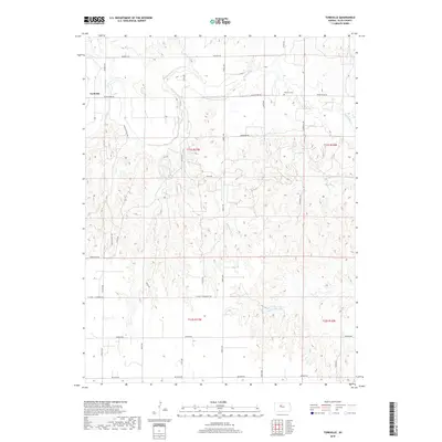
2018 Map of Turkville
USGS Topo · Published 2018About this map
Turkville sits along the winding course of the Saline River in this Ellis County landscape, where the prairie is dissected by narrow drainages like Sweetwater Cr. The settlement pattern is defined by a grid of rural roads, including Hadley Range Ave, Codell Ave, and Toulon Ave, which provide access to the dispersed farmsteads characteristic of the High Plains. Evidence of early settlement is preserved at the Norman Cem near Saline River Rd, reflecting the community's ancestral ties to the land. The topography transitions from the river valley to higher ground marked by routes such as St John - St Andrew Rd and Buckeye Rd. This 2018 survey illustrates the persistent agricultural and ranching layout of the region, where township boundaries like t11s r17w and t11s r16w continue to organize the landscape nearly a century after initial homesteading.
Find a feature on this map
26 named features on this map. Tap any name to fly to it.
Don’t see what you’re looking for? This feature index may not catch every label — zoom into the map to look around manually.
Map Details
Editions of this 2018 Turkville Map
This is the sole edition of this map. No revisions or reprints were ever made.
Other maps of this area

1896 · Hays
USGS Topo · 1:125,000

1896 · Plainville
USGS Topo · 1:125,000

1955 · Great Bend
USGS Topo · 1:250,000

1955 · Beloit
USGS Topo · 1:250,000

1957 · Great Bend
USGS Topo · 1:250,000

1958 · Great Bend
USGS Topo · 1:250,000

1959 · Beloit
USGS Topo · 1:250,000

1961 · Catharine
USGS Topo · 1:24,000
1961 · Hays North
USGS Topo · 1:24,000
1967 · Gorham
USGS Topo · 1:24,000