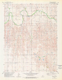
1978 Map of Turkville
USGS Topo · Published 1979About this map
Turkville sits along the winding course of the Saline River in Ellis County, marking a landscape defined by 1970s energy extraction and rural infrastructure. The most prominent industrial feature is the Bemis Shutts Oil Field, which spans a significant portion of the terrain across the Catherine, Herzog, and Buckeye districts. The map provides a detailed view of the extensive network of secondary roads and field lines required to service numerous Oil Wells and Gravel Pits scattered throughout the river valley and upland breaks.
Find a feature on this map
15 named features on this map. Tap any name to fly to it.
Don’t see what you’re looking for? This feature index may not catch every label — zoom into the map to look around manually.
Map Details
Editions of this 1978 Turkville Map
This is the sole edition of this map. No revisions or reprints were ever made.
Other maps of this area

1896 · Hays
USGS Topo · 1:125,000

1896 · Plainville
USGS Topo · 1:125,000

1955 · Great Bend
USGS Topo · 1:250,000

1955 · Beloit
USGS Topo · 1:250,000

1957 · Great Bend
USGS Topo · 1:250,000

1958 · Great Bend
USGS Topo · 1:250,000

1959 · Beloit
USGS Topo · 1:250,000

1961 · Catharine
USGS Topo · 1:24,000
1961 · Hays North
USGS Topo · 1:24,000
1967 · Gorham
USGS Topo · 1:24,000