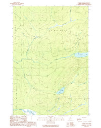
1989 Map of Turner Pond
USGS Topo · Published 1989About this map
St John River and its major tributary, the Baker Branch St John River, define the southern edge of this remote Maine logging landscape. The interior is a dense network of hydrologic features including St Francis Lake and its namesake St Francis Brook, alongside Turner Pond and Turner Brook. In this late-twentieth-century survey, the traditional Maine township and range system is evident, with boundaries for T 8 R 1 6 W E L S and surrounding divisions clearly marked. The lack of public thoroughfares is notable; the few transit routes through the timberlands are exclusively marked as Private roads, illustrating the industrial and restricted nature of the backcountry during this period. The survey captures a moment before modern digital mapping, documenting the intricate flow of the Desolation Brook and Campbell Branch North through the Somerset County woods.
Find a feature on this map
13 named features on this map. Tap any name to fly to it.
Don’t see what you’re looking for? This feature index may not catch every label — zoom into the map to look around manually.
Map Details
Editions of this 1989 Turner Pond Map
This is the sole edition of this map. No revisions or reprints were ever made.
Other maps of this area

1954 · Baker Lake
USGS Topo · 1:62,500

1954 · Caucomgomoc Lake
USGS Topo · 1:62,500

1954 · Allagash Lake
USGS Topo · 1:62,500

1954 · St. John Pond
USGS Topo · 1:62,500

1954 · Presque Isle
USGS Topo · 1:250,000

1958 · Presque Isle
USGS Topo · 1:250,000

1958 · Caucomgomoc Lake
USGS Topo · 1:62,500

1958 · Saint John Pond
USGS Topo · 1:62,500

1960 · Presque Isle
USGS Topo · 1:250,000

1961 · Allagash Lake
USGS Topo · 1:62,500