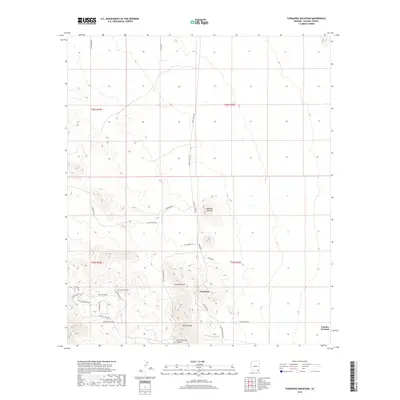
2018 Map of Turquoise Mountain
USGS Topo · Published 2018About this map
Courtland sits at the heart of this landscape, surrounded by high desert peaks and a network of roads that hint at the region's mining heritage. The names themselves tell a story of prospecting and extraction, with W Prospectors Rd, W Copper Belle Rd, and W Copper Bug Rd winding through the foothills of Turquoise Mtn. To the north and south of the settlement, N Ghost Town Trl and S Ghost Town Trl follow the path of earlier eras. The topography is dominated by distinct elevations like Mexican Hat Mtn and Browns Peak, while Dead Mexican Canyon cuts through the southern terrain. Farther east, the landscape transitions toward Grizzles Orchard, illustrating the varied uses of this Cochise County terrain.
Find a feature on this map
32 named features on this map. Tap any name to fly to it.
Don’t see what you’re looking for? This feature index may not catch every label — zoom into the map to look around manually.
Map Details
Editions of this 2018 Turquoise Mountain Map
This is the sole edition of this map. No revisions or reprints were ever made.
Other maps of this area

1916 · Pearce
USGS Topo · 1:125,000

1922 · Swisshelm
USGS Topo · 1:62,500

1925 · Gleeson
USGS Topo · 1:62,500

1926 · Light
USGS Topo · 1:62,500

1926 · Courtland
USGS Topo · 1:62,500

1955 · Douglas
USGS Topo · 1:250,000
1957 · Hay Mountain
USGS Topo · 1:24,000

1958 · Squaretop Hills
USGS Topo · 1:62,500

1958 · Swisshelm Mtn
USGS Topo · 1:62,500

1958 · Pearce
USGS Topo · 1:62,500