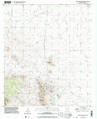
1996 Map of Turquoise Mountain
USGS Topo · Published 2003About this map
Turquoise Mountain rises as the centerpiece of this Arizona landscape, surrounded by an extensive network of mineral extraction sites recorded during the 1970s and 1990s. The terrain is marked by dozens of prospects, mine shafts, and several adits, particularly concentrated around the slopes of Browns Peak and Mexican Hat Mountain. This concentration of labels suggests a history of intensive small-scale prospecting and mining development in the Dragoon Mountains region.
Find a feature on this map
21 named features on this map. Tap any name to fly to it.
Don’t see what you’re looking for? This feature index may not catch every label — zoom into the map to look around manually.
Map Details
Editions of this 1996 Turquoise Mountain Map
This is the sole edition of this map. No revisions or reprints were ever made.
Other maps of this area

1916 · Pearce
USGS Topo · 1:125,000

1922 · Swisshelm
USGS Topo · 1:62,500

1925 · Gleeson
USGS Topo · 1:62,500

1926 · Light
USGS Topo · 1:62,500

1926 · Courtland
USGS Topo · 1:62,500

1955 · Douglas
USGS Topo · 1:250,000
1957 · Hay Mountain
USGS Topo · 1:24,000

1958 · Squaretop Hills
USGS Topo · 1:62,500

1958 · Swisshelm Mtn
USGS Topo · 1:62,500

1958 · Pearce
USGS Topo · 1:62,500