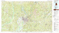
1984 Map of Tuscaloosa
USGS Topo · Published 1988About this map
The Black Warrior River and its series of impoundments, including Holt Lake and Bankhead Lake, anchor this mid-1980s landscape of West Central Alabama. The growing urban centers of Tuscaloosa and Northport serve as the region's core, defined by the sprawling campuses of the University of Alabama and Stillman College. Transportation and industrial patterns are evident through the dense network of the Southern Railway and the presence of numerous Strip Mines scattered through the eastern hills, particularly around Brookwood and Kellerman.
Find a feature on this map
107 named features on this map. Tap any name to fly to it.
Don’t see what you’re looking for? This feature index may not catch every label — zoom into the map to look around manually.
Map Details
Editions of this 1984 Tuscaloosa Map
2 editions found
Other maps of this area

1889 · Birmingham
USGS Topo · 1:125,000

1890 · Bessemer
USGS Topo · 1:125,000

1891 · Clanton
USGS Topo · 1:125,000

1892 · Birmingham
USGS Topo · 1:125,000

1892 · Bessemer
USGS Topo · 1:125,000

1893 · Jasper
USGS Topo · 1:125,000

1895 · Birmingham
USGS Topo · 1:125,000

1899 · Brookwood
USGS Topo · 1:125,000

1904 · Birmingham Coal District
USGS Topo · 1:62,500

1905 · Bessemer Iron District
USGS Topo · 1:62,500