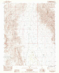
1984 Map of Twelvemile Spring
USGS Topo · Published 1984About this map
Mining operations and remote desert hydrology define this 1984 survey of eastern Inyo County. The landscape is dominated by the massive Resting Spring Range and the Nopah Range, which flank the broad expanse of the Chicago Valley. This area represents a classic Great Basin environment where resource extraction was the primary human imprint, evidenced by the presence of the Baxter Mine in the north and the Red Wing Mine and Gerstley Mine further south. These sites provide a record of the mid-to-late 20th-century mineral exploration in this corner of the Mojave Desert. Critical water sources like Twelvemile Spring stand out as essential landmarks in an otherwise arid terrain, highlighting the points of survival and settlement that guided early prospecting and travel routes between these mountain blocks.
Find a feature on this map
7 named features on this map. Tap any name to fly to it.
Don’t see what you’re looking for? This feature index may not catch every label — zoom into the map to look around manually.
Map Details
Editions of this 1984 Twelvemile Spring Map
This is the sole edition of this map. No revisions or reprints were ever made.
Other maps of this area

1908 · Furnace Creek
USGS Topo · 1:250,000

1910 · Furnace Creek
USGS Topo · 1:250,000

1933 · Avawatz Mountains
USGS Topo · 1:250,000

1940 · Eagle Tank
USGS Topo · 1:62,500

1947 · Trona
USGS Topo · 1:250,000

1948 · Trona
USGS Topo · 1:250,000

1948 · Death Valley
USGS Topo · 1:250,000

1950 · Tecopa
USGS Topo · 1:62,500

1951 · Tecopa
USGS Topo · 1:62,500

1951 · Eagle Mtn
USGS Topo · 1:62,500