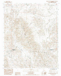
1985 Map of Twentynine Palms Mountain
USGS Topo · Published 1985About this map
The Pinto Mountains dominate this high desert landscape, which in the mid-1980s remained a center for both aviation and mineral extraction. This quadrangle sits at the border of San Bernardino and Riverside Counties, characterized by the prominence of Twentynine Palms Mountain and the expansive Music Valley. The area's mining history is well-documented through a cluster of named sites in the southwest, including the North Star Mine, Goat Basin Mine, Atlanta Mine, and Carlos Jr Mine near the settlement of Gold Park.
Find a feature on this map
14 named features on this map. Tap any name to fly to it.
Don’t see what you’re looking for? This feature index may not catch every label — zoom into the map to look around manually.
Map Details
Editions of this 1985 Twentynine Palms Mountain Map
2 editions found
Other maps of this area

1942 · Amboy
USGS Topo · 1:250,000

1943 · Amboy
USGS Topo · 1:250,000

1943 · Pinkham Well
USGS Topo · 1:62,500

1944 · Pinkham Well
USGS Topo · 1:62,500

1944 · Pinyon Well
USGS Topo · 1:62,500

1947 · Santa Ana
USGS Topo · 1:250,000

1949 · Santa Ana
USGS Topo · 1:250,000

1953 · San Bernardino
USGS Topo · 1:250,000

1954 · Salton Sea
USGS Topo · 1:250,000

1954 · Needles
USGS Topo · 1:250,000