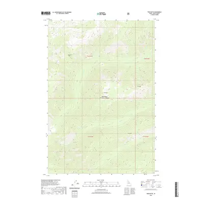
2020 Map of Twin Butte
USGS Topo · Published 2020About this map
Nez Perce National Forest encompasses this entire Idaho County landscape, defined by a series of prominent high-elevation ridges and deep creek drainages. The topography is dominated by the namesake Twin Butte and the long, sloping spines of Pettibone Ridge, Elk Ridge, and Long Ridge. These natural landforms dictate the flow of numerous waterways, including Pettibone Cr, Bear Cr, and Paradise Cr. This map represents the area's modern state under federal management, showing a territory devoid of permanent settlements but rich in named natural landmarks. The land is organized by the Public Land Survey System, with boundaries for several townships including t32n r14e and t31n r14e clearly marked. The drainage network is particularly dense, with Squaw Cr, Santa Cr, and Eben Cr carving through the steep terrain to reach the larger creek basins.
Find a feature on this map
17 named features on this map. Tap any name to fly to it.
Don’t see what you’re looking for? This feature index may not catch every label — zoom into the map to look around manually.
Map Details
Editions of this 2020 Twin Butte Map
This is the sole edition of this map. No revisions or reprints were ever made.
Other maps of this area

1911 · Lolo
USGS Topo · 1:250,000

1913 · Lolo
USGS Topo · 1:250,000

1956 · Elk City
USGS Topo · 1:250,000

1956 · Hamilton
USGS Topo · 1:250,000

1959 · Hamilton
USGS Topo · 1:250,000

1960 · Elk City
USGS Topo · 1:250,000

1960 · Hamilton
USGS Topo · 1:250,000

1964 · Hamilton
USGS Topo · 1:250,000

1966 · Twin Butte
USGS Topo · 1:24,000
1966 · Mount Paloma
USGS Topo · 1:24,000