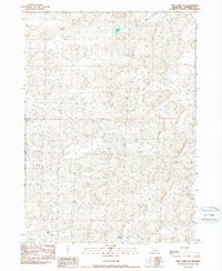
1989 Map of Twin Lakes NE
USGS Topo · Published 1989About this map
Nelson Ranch and Forney Ranch anchor this late-1980s look at Sheridan County, where the Sandhills landscape is defined by its agricultural operations and water resources. The terrain is marked by a network of 4wd trails that navigate the rolling topography between the headwaters of Deer Creek and the marshy edges of Spring Lake. This provisional survey illustrates the isolation and functional layout of high-plains ranching, complete with a remote Landing Strip and localized Well sites. The boundary between T 29 N and T 28 N runs through the center of the sheet, providing a clear reference for land ownership researchers and those tracing the historic property lines of these northern Nebraska cattle operations during the late twentieth century.
Find a feature on this map
8 named features on this map. Tap any name to fly to it.
Don’t see what you’re looking for? This feature index may not catch every label — zoom into the map to look around manually.
Map Details
Editions of this 1989 Twin Lakes NE Map
This is the sole edition of this map. No revisions or reprints were ever made.
Other maps of this area

1948 · Twin Lakes
USGS Topo · 1:62,500

1948 · Spade Ranch
USGS Topo · 1:62,500

1950 · Twin Lakes
USGS Topo · 1:62,500

1950 · Spade Ranch
USGS Topo · 1:62,500

1955 · Alliance
USGS Topo · 1:250,000

1957 · Alliance
USGS Topo · 1:250,000

1958 · Alliance
USGS Topo · 1:250,000

1966 · Rushville SW
USGS Topo · 1:24,000

1969 · Rushville 4 SW
USGS Topo · 1:24,000

1969 · Rushville SE
USGS Topo · 1:24,000