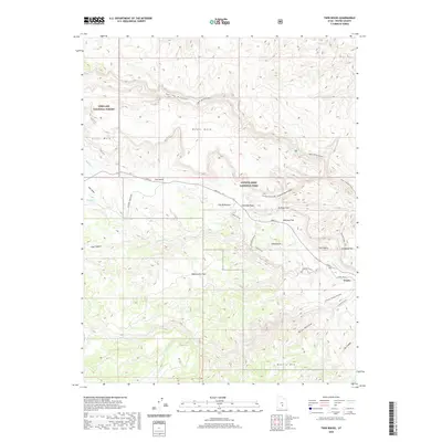
2020 Map of Twin Rocks
USGS Topo · Published 2020About this map
Capitol Reef National Park and the Fishlake National Forest define this high-desert landscape in Wayne County. The map details the transition from the high elevations of Cooks Mesa and Meeks Mesa down into the canyon systems carved by the Fremont River and Sulphur Creek. Historical settlement is represented by Fruita, while the topography includes distinctive geological formations like The Castle and Mummy Cliff. Notable landforms such as Goosenecks and Sunset Point overlook the intricate drainage patterns of Spring Canyon and Wide Hollow. The convergence of Utah 24 and the Scenic Drive facilitates access through this complex terrain, passing landmarks like Chimney Rock and The Motorman. Researchers can trace the varied network of watercourses, including Carcass Cr and Fish Cr, which have shaped the local geography and historical land use patterns on the Beas Lewis Flats.
Find a feature on this map
38 named features on this map. Tap any name to fly to it.
Don’t see what you’re looking for? This feature index may not catch every label — zoom into the map to look around manually.
Map Details
Editions of this 2020 Twin Rocks Map
This is the sole edition of this map. No revisions or reprints were ever made.
Other maps of this area

1885 · Fish Lake
USGS Topo · 1:250,000

1896 · Fish Lake
USGS Topo · 1:250,000

1952 · Notom 2 NW
USGS Topo · 1:24,000

1952 · Notom 3 NW
USGS Topo · 1:24,000

1952 · Notom 2 SE
USGS Topo · 1:24,000

1952 · Notom 2 SW
USGS Topo · 1:24,000

1952 · Notom 4 NW
USGS Topo · 1:24,000

1952 · Notom 2 NE
USGS Topo · 1:24,000

1952 · Notom 3 NE
USGS Topo · 1:24,000

1952 · Notom 1 SW
USGS Topo · 1:24,000