1971 Map of Two Buttes
USGS Topo · Published 1973About this map
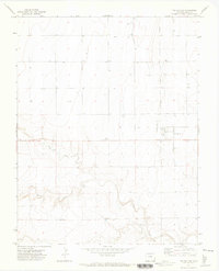
Two Buttes stands as a focal point in this southeastern Colorado landscape, situated at the intersection of a grid of local roads and an unpaved Landing Strip. The topography here is defined by the winding paths of Horse Creek and Sand Creek, which carve distinct drainage patterns through the surrounding high plains. Near the center of the sheet, the Radio Tower Stephen serves as a modern navigational landmark amidst a vast network of survey sections and section lines. Numerous Wells and individual Well markers are scattered throughout the quadrangle, indicating the critical role of groundwater management for the local ranching or agricultural operations in this arid region of Baca County.
Find a feature on this map
8 named features on this map. Tap any name to fly to it.
Don’t see what you’re looking for? This feature index may not catch every label — zoom into the map to look around manually.
Map Details
Editions of this 1971 Two Buttes Map
This is the sole edition of this map. No revisions or reprints were ever made.
Other maps of this area

1891 · Albany
USGS Topo · 1:125,000

1891 · Springfield
USGS Topo · 1:125,000
1892 · Vilas
USGS Topo · 1:125,000

1892 · Two Butte
USGS Topo · 1:125,000

1893 · Two Butte
USGS Topo · 1:125,000

1893 · Springfield
USGS Topo · 1:125,000
1893 · Albany
USGS Topo · 1:125,000

1955 · La Junta
USGS Topo · 1:250,000

1958 · La Junta
USGS Topo · 1:250,000

1968 · La Junta
USGS Topo · 1:250,000