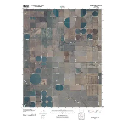
2010 Map of Two Buttes SE
USGS Topo · Published 2010About this map
The high plains of southeast Colorado are defined by a strict geometric grid of section roads and the winding paths of intermittent waterways. Two Buttes Cemetery sits as a primary landmark in this agricultural landscape, located along the western edge of the quadrangle. The terrain is bisected by the meandering course of Little Horse Creek, which flows southeast toward the corner of the map. Further north, the drainage of Buffalo Creek cuts through the surveyed plots, while Horse Creek appears in the far southwest corner. The dominance of the road system, including routes like County Road VV and County Road SS, reflects the enduring legacy of the Public Land Survey System in organizing this rural expanse.
Find a feature on this map
15 named features on this map. Tap any name to fly to it.
Don’t see what you’re looking for? This feature index may not catch every label — zoom into the map to look around manually.
Map Details
Editions of this 2010 Two Buttes SE Map
This is the sole edition of this map. No revisions or reprints were ever made.
Other maps of this area

1891 · Albany
USGS Topo · 1:125,000

1892 · Vilas
USGS Topo · 1:125,000

1893 · Albany
USGS Topo · 1:125,000

1955 · La Junta
USGS Topo · 1:250,000

1958 · La Junta
USGS Topo · 1:250,000

1968 · La Junta
USGS Topo · 1:250,000
1971 · Plains Community
USGS Topo · 1:24,000

1971 · Two Buttes SE
USGS Topo · 1:24,000
1971 · Lycan
USGS Topo · 1:24,000
1971 · Webb
USGS Topo · 1:24,000