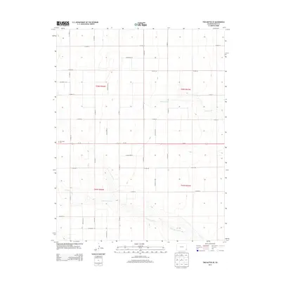
2013 Map of Two Buttes SE
USGS Topo · Published 2013About this map
Little Horse Creek and Buffalo Creek trace a distinct drainage pattern across this high plains landscape of Baca County, where the topography is defined by the sharp incisions of these seasonal waterways. The terrain reveals the organized grid of the Public Land Survey System, with section lines marked by a network of county roads including Co Road 39 and Co Road 42. This rural character is anchored by the Two Buttes Cem in the western portion of the quadrangle, serving as a primary landmark for genealogists and local historians tracing the settlement history of the region. The map shows the transition from flat upland mesas to the breaks and draws created by the watercourses, all bisected by the straight path of Co-116 running east-west across the center of the survey area.
Find a feature on this map
28 named features on this map. Tap any name to fly to it.
Don’t see what you’re looking for? This feature index may not catch every label — zoom into the map to look around manually.
Map Details
Editions of this 2013 Two Buttes SE Map
This is the sole edition of this map. No revisions or reprints were ever made.
Other maps of this area

1891 · Albany
USGS Topo · 1:125,000

1892 · Vilas
USGS Topo · 1:125,000

1893 · Albany
USGS Topo · 1:125,000

1955 · La Junta
USGS Topo · 1:250,000

1958 · La Junta
USGS Topo · 1:250,000

1968 · La Junta
USGS Topo · 1:250,000
1971 · Plains Community
USGS Topo · 1:24,000

1971 · Two Buttes SE
USGS Topo · 1:24,000
1971 · Lycan
USGS Topo · 1:24,000
1971 · Webb
USGS Topo · 1:24,000