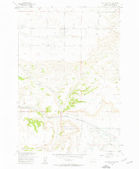
1956 Map of Two Pine School
USGS Topo · Published 1958About this map
Two Pine School stands as a lonely landmark in the high plains of Yellowstone County, anchoring a landscape defined more by its drainage networks than by its settlements. This 1950s survey captures a transition in land use, where traditional ranching elements like a Silo and various wells sit alongside modern infrastructure like a high-pressure Pipeline. The terrain is deeply incised by the North Fork Buffalo Creek and South Fork Buffalo Creek, creating a complex series of canyons that challenge movement across the central portion of the sheet. Most evocative is the curiously named Calamity Jane Horse Cache Creek in the southern half, a label that hints at regional folk history and the era's lingering connection to frontier lore. Researchers will note how the Base Line survey boundary cuts through the heart of these draws, organizing the otherwise irregular topography of Cove Creek and Dry Creek.
Find a feature on this map
13 named features on this map. Tap any name to fly to it.
Don’t see what you’re looking for? This feature index may not catch every label — zoom into the map to look around manually.
Map Details
Editions of this 1956 Two Pine School Map
2 editions found
Other maps of this area

1954 · Billings
USGS Topo · 1:250,000

1956 · Comanche
USGS Topo · 1:24,000

1956 · Acton
USGS Topo · 1:24,000

1956 · Molt
USGS Topo · 1:24,000

1956 · Rock Spring
USGS Topo · 1:24,000

1956 · Rimrock
USGS Topo · 1:24,000

1956 · Two Pine School
USGS Topo · 1:24,000

1956 · Laurel
USGS Topo · 1:24,000

1956 · Park City
USGS Topo · 1:24,000

1956 · Mossmain
USGS Topo · 1:24,000