
1956 Map of Park City
USGS Topo · Published 1958About this map
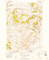
Park City serves as the primary settlement on this mid-century survey, situated along the Northern Pacific railroad corridor. The landscape is defined by the transition from the upland reaches of Coombs Flat to the complex drainage systems of Sawmill Gulch and Cottonwood Creek. An extensive irrigation network, including the Big Ditch, Cove Ditch, and Old Mill Ditch, reveals the intensive water management required for agriculture in this portion of the Missouri River Basin. Genealogists may find interest in the Pioneer Cem located near the town site, while distinctive landforms like Miller Butte and Square Butte provide prominent natural landmarks. The map also records the county boundary between Stillwater and Yellowstone Counties, marking the political geography as it existed during the field checks in 1956.
Find a feature on this map
19 named features on this map. Tap any name to fly to it.
Don’t see what you’re looking for? This feature index may not catch every label — zoom into the map to look around manually.
Map Details
Editions of this 1956 Park City Map
2 editions found
Other maps of this area

1892 · Stillwater
USGS Topo · 1:125,000

1954 · Billings
USGS Topo · 1:250,000

1956 · Hunter Lake
USGS Topo · 1:24,000

1956 · Horse Butte
USGS Topo · 1:24,000

1956 · Molt
USGS Topo · 1:24,000

1956 · Silesia
USGS Topo · 1:24,000

1956 · Rapids
USGS Topo · 1:24,000

1956 · Two Pine School
USGS Topo · 1:24,000

1956 · Laurel
USGS Topo · 1:24,000
1956 · Montaqua
USGS Topo · 1:24,000