
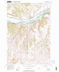
1956 Map of Rapids
USGS Topo · Published 1958About this map
The Yellowstone River cuts a prominent path through this 1950s landscape, serving as a geographic divide and the foundation for regional irrigation. Significant engineering is evident in the Cove Ditch and Big Ditch, which divert water to support agriculture along the river valley. The Northern Pacific railroad follows the northern bank, passing through the small siding at Rapids and near Youngs Point, illustrating the vital connection between rail transport and the rural economy.
Find a feature on this map
23 named features on this map. Tap any name to fly to it.
Don’t see what you’re looking for? This feature index may not catch every label — zoom into the map to look around manually.
Map Details
Editions of this 1956 Rapids Map
2 editions found
Other maps of this area

1892 · Stillwater
USGS Topo · 1:125,000

1932 · Red Lodge No 1
USGS Topo · 1:48,000

1954 · Billings
USGS Topo · 1:250,000

1956 · Shane Ridge
USGS Topo · 1:24,000

1956 · Horse Butte
USGS Topo · 1:24,000

1956 · Columbus East
USGS Topo · 1:24,000

1956 · Fromberg
USGS Topo · 1:24,000
1956 · Boyd
USGS Topo · 1:24,000

1956 · Park City
USGS Topo · 1:24,000
1956 · Cooney Reservoir
USGS Topo · 1:24,000