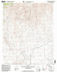
1995 Map of Tylerhorse Canyon
USGS Topo · Published 1999About this map
The high desert landscape where the Tehachapi Mountains meet the Antelope Valley is captured in this survey, updated for the mid-1990s. The northern reaches are defined by steep canyons including Tylerhorse Canyon, Gamble Spring Canyon, and Bean Canyon, while the southern flats reveal the expansion of road networks such as Meers Road and 140th Street West. A critical artery of California's water infrastructure, the Los Angeles Aqueduct, cuts across the lower half of the map, signifying the engineering efforts required to sustain the region.
Find a feature on this map
21 named features on this map. Tap any name to fly to it.
Don’t see what you’re looking for? This feature index may not catch every label — zoom into the map to look around manually.
Map Details
Editions of this 1995 Tylerhorse Canyon Map
2 editions found
Other maps of this area

1903 · Tejon
USGS Topo · 1:125,000

1914 · Caliente
USGS Topo · 1:125,000

1915 · Elizabeth Lake
USGS Topo · 1:125,000

1915 · Mojave
USGS Topo · 1:125,000

1917 · Elizabeth Lake
USGS Topo · 1:125,000

1943 · Tehachapi
USGS Topo · 1:62,500

1943 · Cummings Mountain
USGS Topo · 1:62,500

1943 · Neenach
USGS Topo · 1:62,500

1943 · Willow Springs
USGS Topo · 1:62,500

1948 · Bakersfield
USGS Topo · 1:250,000