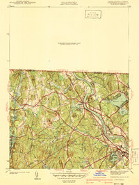
1941 Map of Tyngsboro
USGS Topo · Published 1941About this map
The Merrimack River snakes through this 1939 survey of the Massachusetts-New Hampshire borderlands, a landscape defined by its glacial terrain and industrial granite extraction. Heavy quarrying activity is evident at Flat Rock Quarry and Fletcher Quarry, highlighting the region's contribution to the building trades of the era. Settlement is concentrated in Tyngsboro and North Chelmsford, while rural crossroads like Swan Corner and Flints Corner mark the intersections of a developing road network that includes Middlesex Road and Pawtucket Blvd. The presence of Notre Dame Academy and the Marist Sch alongside numerous burial grounds such as Central Cem and Fairview Cem provides a detailed view of the social fabric and community centers established before mid-century suburbanization. Near Tyngs Island, the Vesper Country Club occupies a bend in the river, showing the early 20th-century expansion of recreational land use.
Find a feature on this map
81 named features on this map. Tap any name to fly to it.
Don’t see what you’re looking for? This feature index may not catch every label — zoom into the map to look around manually.
Map Details
Editions of this 1941 Tyngsboro Map
2 editions found
Other maps of this area

1886 · Lowell
USGS Topo · 1:62,500

1893 · Lowell
USGS Topo · 1:62,500

1893 · Groton
USGS Topo · 1:62,500

1905 · Manchester
USGS Topo · 1:62,500

1906 · Milford
USGS Topo · 1:62,500

1918 · Lowell
USGS Topo · 1:62,500

1921 · Lowell
USGS Topo · 1:62,500

1931 · Lowell
USGS Topo · 1:48,000

1931 · Groton
USGS Topo · 1:48,000

1935 · Ayer
USGS Topo · 1:24,000