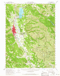
1958 Map of Ukiah
USGS Topo · Published 1966About this map
The Russian River corridor serves as the industrial and agricultural spine of this Mendocino County region in the late 1950s. The city of Ukiah is established as a regional hub, flanked by the Northwestern Pacific railroad and a dense network of local institutions, including the Mendocino State Hospital, the Fairgrounds, and numerous schools like Pomolita Sch and Nokomis School. To the north, the newly formed Mendocino Lake sits behind its intake tower, while the landscape to the east rises into the Mayacmas Mountains, characterized by high peaks like Shell Peak and the remote Eightmile Valley. The map records a complex human geography, showing the Pinoliville Rancheria and Guidiville Rancheria alongside established rural interests such as the Yokayo Ranch and Vichy Springs. In the south, smaller clusters like Talmage, Largo, and the Hopland Field Sta indicate the area's ongoing importance for viticulture and research.
Find a feature on this map
106 named features on this map. Tap any name to fly to it.
Don’t see what you’re looking for? This feature index may not catch every label — zoom into the map to look around manually.
Map Details
Editions of this 1958 Ukiah Map
2 editions found
Other maps of this area

1920 · Ukiah
USGS Topo · 1:62,500

1921 · Kelseyville
USGS Topo · 1:62,500

1922 · Willits
USGS Topo · 1:62,500

1922 · Hullville
USGS Topo · 1:62,500

1938 · Lakeport
USGS Topo · 1:62,500

1938 · Hopland
USGS Topo · 1:62,500

1942 · Willits
USGS Topo · 1:62,500

1943 · Pomo
USGS Topo · 1:62,500

1943 · Boonville
USGS Topo · 1:62,500

1943 · Kelseyville
USGS Topo · 1:62,500