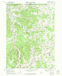
1969 Map of Ulysses
USGS Topo · Published 1972About this map
Genesee and Ulysses anchor this 1969 topographic study of the northern tier, where the West Branch Genesee River and Middle Branch Genesee River flow toward the New York state line. The landscape is defined by its industrial utility, featuring an extensive Underground Gas Storage Field and numerous pipelines cutting across the terrain. Remnants of former transportation networks are evident in the Old RR Gr and Old Railroad Grade that parallel the river valleys and hollows. The rural character of Potter County is preserved through small clusters of development at Hickox, Kibbeville Corners, and North Bingham, which is marked by the North Bingham Cem. Aviation history is noted at Hickox Landing Field along the river, while the Wellsville Addison and Galeton route provides a primary corridor through the hills and hollows.
Find a feature on this map
37 named features on this map. Tap any name to fly to it.
Don’t see what you’re looking for? This feature index may not catch every label — zoom into the map to look around manually.
Map Details
Editions of this 1969 Ulysses Map
2 editions found
Other maps of this area

1899 · Gaines
USGS Topo · 1:62,500

1900 · Gaines
USGS Topo · 1:62,500

1926 · Wellsville
USGS Topo · 1:62,500

1926 · Greenwood
USGS Topo · 1:62,500

1932 · Genesee
USGS Topo · 1:62,500

1937 · Genesee
USGS Topo · 1:62,500

1950 · Elmira
USGS Topo · 1:250,000

1954 · Williamsport
USGS Topo · 1:250,000
1957 · Harrison Valley
USGS Topo · 1:24,000

1958 · Elmira
USGS Topo · 1:250,000