
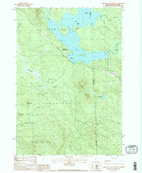
1988 Map of Umbagog Lake South
USGS Topo · Published 1988About this map
Umbagog Lake dominates this New Hampshire and Maine borderland, where the waters of the Dead Cambridge and various brooks converge near the township of Upton. Recorded in the late 1980s, the landscape reflects a balance of recreational and natural resource use, featuring the Umbagog State Park and several islands such as Metallak Island and Bear Island. The terrain is defined by significant elevations like Black Mountain and the Hampshire Hills, with the state boundary cutting through the dense timberland and marshy reaches of Bog Brook and Mollidgewock Pond. Local industry and infrastructure are represented by a Gravel Pit near the lake's edge and a designated Boat Ramp, marking the transition between the settlement at Upton and the surrounding wilderness of the Grafton and Coos and Oxford County lines.
Find a feature on this map
33 named features on this map. Tap any name to fly to it.
Don’t see what you’re looking for? This feature index may not catch every label — zoom into the map to look around manually.
Map Details
Editions of this 1988 Umbagog Lake South Map
2 editions found
Other maps of this area

1930 · Milan
USGS Topo · 1:62,500

1930 · Errol
USGS Topo · 1:62,500

1933 · Milan
USGS Topo · 1:62,500

1934 · Errol
USGS Topo · 1:62,500

1934 · Milan
USGS Topo · 1:62,500

1940 · Oquossoc
USGS Topo · 1:62,500

1942 · Oquossoc
USGS Topo · 1:62,500

1943 · Old Speck Mtn
USGS Topo · 1:62,500

1945 · Old Speck Mtn
USGS Topo · 1:62,500

1950 · Lewiston
USGS Topo · 1:250,000