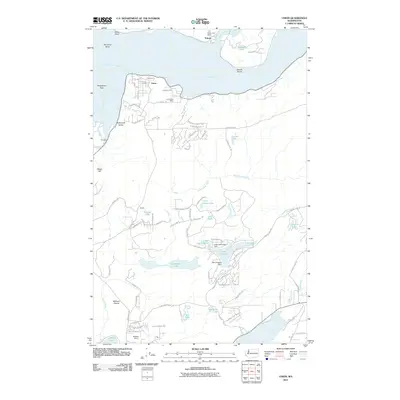
2011 Map of Union
USGS Topo · Published 2011About this map
Hood Canal dominates the northern landscape of this region where the Great Bend shapes the coastline near the Skokomish Flats. The settlement of Union sits prominently along the shore, supported by the Union Post Office, while the northern village of Tahuya serves as a gateway to the Tahuya River and its own Tahuya Post Office. The interior reveals a sophisticated network of artificial water bodies and water management, centered around Lake Limerick and Lake Leprechaun, both controlled by their respective dams. The map illustrates a shift from the low-lying Skokomish Valley and McEwen Prairie to more developed residential corridors like Vuecrest Way. From the high ground at Webb Hill to the opening of Oakland Bay, the landscape is defined by the transition between saltwater inlets and upland lakes such as Carson Lake and Rainbow Lake.
Find a feature on this map
82 named features on this map. Tap any name to fly to it.
Don’t see what you’re looking for? This feature index may not catch every label — zoom into the map to look around manually.
Map Details
Editions of this 2011 Union Map
This is the sole edition of this map. No revisions or reprints were ever made.
Other maps of this area

1937 · Olympia
USGS Topo · 1:62,500

1938 · Allyn
USGS Topo · 1:62,500

1939 · Shelton
USGS Topo · 1:62,500

1943 · Potlatch
USGS Topo · 1:62,500

1949 · Olympia
USGS Topo · 1:62,500

1952 · Potlatch
USGS Topo · 1:62,500

1953 · Lake Wooten
USGS Topo · 1:24,000
1953 · Mason Lake
USGS Topo · 1:24,000

1953 · Shelton
USGS Topo · 1:62,500

1958 · Seattle
USGS Topo · 1:250,000