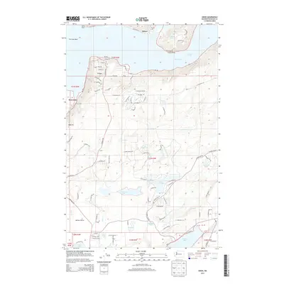
2014 Map of Union
USGS Topo · Published 2014About this map
The Great Bend of the Hood Canal serves as the focal point for this survey of Mason County, where the settlement of Union sits along the southern shore. The map illustrates a landscape transitioning from the coastal waters of The Narrows to the interior highlands around Webb Hill. This region is defined by a dense network of small lakes and residential developments, including Lake Limerick, Lake Leprechaun, and Little Island Lake, showing the modern layout of suburban communities such as Amelia and Fernwood. To the north, across the canal, the community of Tahuya is situated near Ayres Point. The intricate hydrology of the area is well-documented, with Johns Cr and Cranberry Cr draining the glacial topography towards Oakland Bay. The presence of the Skokomish reservation area in the west highlights the varied land use patterns between tribal lands, planned communities, and the coastal waterfront.
Find a feature on this map
90 named features on this map. Tap any name to fly to it.
Don’t see what you’re looking for? This feature index may not catch every label — zoom into the map to look around manually.
Map Details
Editions of this 2014 Union Map
This is the sole edition of this map. No revisions or reprints were ever made.
Other maps of this area

1937 · Olympia
USGS Topo · 1:62,500

1938 · Allyn
USGS Topo · 1:62,500

1939 · Shelton
USGS Topo · 1:62,500

1943 · Potlatch
USGS Topo · 1:62,500

1949 · Olympia
USGS Topo · 1:62,500

1952 · Potlatch
USGS Topo · 1:62,500

1953 · Lake Wooten
USGS Topo · 1:24,000
1953 · Mason Lake
USGS Topo · 1:24,000

1953 · Shelton
USGS Topo · 1:62,500

1958 · Seattle
USGS Topo · 1:250,000