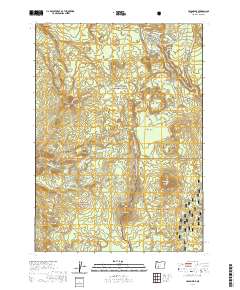
2020 Map of Union Peak
USGS Topo · Published 2020About this map
Crater Lake National Park occupies the northern half of this landscape, where volcanic terrain meets the headwaters of the Rogue Watershed. The jagged heights of Union Peak and the unique formations of Godfrey Glen and Colonnades define the topography near the park's southern boundary. This area serves as a significant crossroads for wilderness travelers, where the Pacific Crest National Scenic Trail winds past Pumice Flat and connects with the Union Peak Trail and Stuart Falls Trail. South of the park line, the terrain transitions into the Rogue River National Forest and Winema National Forest. The map documents a network of remote springs and water features, including Annie Spring and Red Blanket Falls, alongside sites of early forest management and recreation such as Lucky Meadows and the Mckie Camp area near Halifax Cr.
Find a feature on this map
48 named features on this map. Tap any name to fly to it.
Don’t see what you’re looking for? This feature index may not catch every label — zoom into the map to look around manually.
Map Details
Editions of this 2020 Union Peak Map
This is the sole edition of this map. No revisions or reprints were ever made.
Other maps of this area

1891 · Ashland
USGS Topo · 1:250,000

1893 · Ashland
USGS Topo · 1:250,000

1897 · Ashland
USGS Topo · 1:250,000

1955 · Rustler Peak
USGS Topo · 1:62,500

1955 · Pelican Butte
USGS Topo · 1:62,500

1955 · Medford
USGS Topo · 1:250,000

1956 · Prospect
USGS Topo · 1:62,500

1957 · Medford
USGS Topo · 1:250,000

1958 · Medford
USGS Topo · 1:250,000
1975 · Prospect 1 NW
USGS Topo · 1:24,000