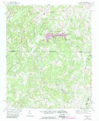
1971 Map of Unity
USGS Topo · Published 1988About this map
The state line between North Carolina and South Carolina bisects this rural landscape, marking the transition between Union Co and Lancaster Co. The 1988 photorevision reveals the expansion of Cane Creek Lake and the establishment of Cane Creek County Park, which significantly altered the local drainage patterns near Simpson Branch. Smaller communities and rural junctions characterize the settlement pattern, including Sapps Crossroads and Lingles Crossroads in the southeast.
Find a feature on this map
40 named features on this map. Tap any name to fly to it.
Don’t see what you’re looking for? This feature index may not catch every label — zoom into the map to look around manually.
Map Details
Editions of this 1971 Unity Map
3 editions found
Other maps of this area

1941 · Spartanburg
USGS Topo · 1:250,000

1953 · Spartanburg
USGS Topo · 1:250,000

1960 · Spartanburg
USGS Topo · 1:250,000

1963 · Spartanburg
USGS Topo · 1:250,000

1964 · Spartanburg
USGS Topo · 1:250,000

1968 · Van Wyck
USGS Topo · 1:24,000
1968 · Catawba NE
USGS Topo · 1:24,000

1969 · Antioch
USGS Topo · 1:24,000
1969 · Lancaster
USGS Topo · 1:24,000
1969 · Taxahaw
USGS Topo · 1:24,000