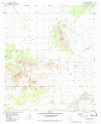
1981 Map of Upham Hills
USGS Topo · Published 1982About this map
Upham Hills and the prominent Point of Rocks define the topography of this high desert region along the boundary of Sierra and Doña Ana counties. Published in 1982, this survey documents a landscape focused on ranching and water management in an arid environment, where scattered catchments like Houge Tank, Turner Tank, and Broke Tank are essential for local operations. The map reflects a period of modern ranching life at the Flat Lake Ranch, situated near the seasonal Flat Lake and the wide Jornada Draw. Multiple drill holes and a network of jeep trails suggest ongoing geological exploration and access throughout the rugged terrain. These features, along with names like Chicken Well and Kacy Tank, provide a detailed record of land use and water rights crucial for genealogists and local historians studying the history of the Jornada del Muerto region.
Find a feature on this map
17 named features on this map. Tap any name to fly to it.
Don’t see what you’re looking for? This feature index may not catch every label — zoom into the map to look around manually.
Map Details
Editions of this 1981 Upham Hills Map
This is the sole edition of this map. No revisions or reprints were ever made.
Other maps of this area

1916 · Tonuco
USGS Topo · 1:125,000

1932 · Tonuco
USGS Topo · 1:125,000

1948 · Chicken Well
USGS Topo · 1:62,500

1948 · San Diego Mountain
USGS Topo · 1:62,500

1955 · Las Cruces
USGS Topo · 1:250,000

1958 · Las Cruces
USGS Topo · 1:250,000

1959 · Rincon
USGS Topo · 1:24,000

1959 · Upham
USGS Topo · 1:62,500

1981 · Gilmore Draw
USGS Topo · 1:24,000
1981 · Prisor Hill
USGS Topo · 1:24,000