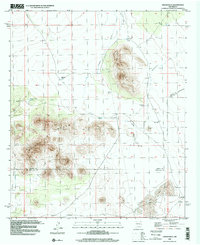
1996 Map of Upham Hills
USGS Topo · Published 2001About this map
Upham Hills and the prominent Point of Rocks define this arid landscape along the border of Sierra and Dona Ana counties. The terrain is shaped by a series of ephemeral water courses and catchment systems essential for ranching, including Jornada Draw, Lyons Draw, and Arroyo Rincon. This late-twentieth-century survey documents the spatial distribution of vital water sources like Chicken Well and numerous stock tanks such as Houge Tank and Pot Hole Tank, which support the livestock operations at Flat Lake Ranch. The presence of the New Mexico Principal Meridian running north-south through the eastern portion of the sheet highlights the systematic land division of the region. A network of 4wd tracks provides the primary means of traversing the basin between the elevated peaks and the low-lying Flat Lake bed.
Find a feature on this map
18 named features on this map. Tap any name to fly to it.
Don’t see what you’re looking for? This feature index may not catch every label — zoom into the map to look around manually.
Map Details
Editions of this 1996 Upham Hills Map
This is the sole edition of this map. No revisions or reprints were ever made.
Other maps of this area

1916 · Tonuco
USGS Topo · 1:125,000

1932 · Tonuco
USGS Topo · 1:125,000

1948 · Chicken Well
USGS Topo · 1:62,500

1948 · San Diego Mountain
USGS Topo · 1:62,500

1955 · Las Cruces
USGS Topo · 1:250,000

1958 · Las Cruces
USGS Topo · 1:250,000

1959 · Rincon
USGS Topo · 1:24,000

1959 · Upham
USGS Topo · 1:62,500

1981 · Gilmore Draw
USGS Topo · 1:24,000
1981 · Prisor Hill
USGS Topo · 1:24,000