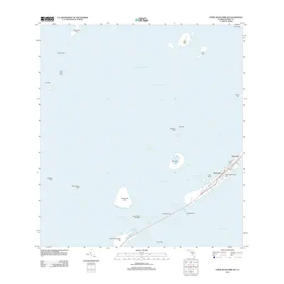
2012 Map of Upper Matecumbe Key
USGS Topo · Published 2012About this map
Upper Matecumbe Key and the village of Islamorada serve as the focal point for this survey of the Florida Keys' transition from the Gulf of Mexico to Florida Bay. The map documents the intricate network of shallow-water channels and basins that define the maritime geography of Monroe County. Key navigation points like Shell Key Channel, Race Channel, and Lignumvitae Channel weave between protected islands including Lignumvitae Key and Teatable Key. The infrastructure of the Overseas Highway is visible as it crosses Indian Key Fill to connect the major keys. Notable landmarks such as The Hok and the residential streets of Madeira Rd and Carroll St illustrate the settled character of the keys in the early 21st century, while surrounding banks like Peterson Key Bank and Twin Key Bank highlight the delicate bathymetry of the region.
Find a feature on this map
41 named features on this map. Tap any name to fly to it.
Don’t see what you’re looking for? This feature index may not catch every label — zoom into the map to look around manually.
Map Details
Editions of this 2012 Upper Matecumbe Key Map
This is the sole edition of this map. No revisions or reprints were ever made.
Other maps of this area

1956 · Miami
USGS Topo · 1:250,000

1958 · Miami
USGS Topo · 1:250,000

1971 · Upper Matecumbe Key
USGS Topo · 1:24,000

1971 · Tavernier
USGS Topo · 1:24,000

1971 · Plantation Key
USGS Topo · 1:24,000

1971 · Long Key
USGS Topo · 1:24,000
1971 · Lower Matecumbe Key
USGS Topo · 1:24,000

1972 · Pelican Keys
USGS Topo · 1:24,000

1972 · Buchanan Keys
USGS Topo · 1:24,000

1972 · Calusa Keys
USGS Topo · 1:24,000