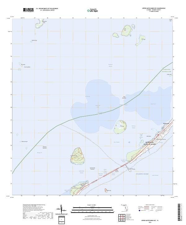
2024 Map of Upper Matecumbe Key
USGS Topo · Published 2024About this map
Islamorada, known as the Village of Islands, anchors this maritime landscape where the waters of Florida Bay meet the Atlantic Ocean. This contemporary survey details the chain of keys and the complex network of channels that define the Florida Straits, including the Intracoastal Waterway and Steamboat Channel. The map highlights protected natural areas such as the Everglades National Park and the expansive Marjory Stoneman Douglas Wilderness, reflecting the region's environmental significance. On the islands, development follows the path of the Florida Keys Overseas Heritage Trl and Old Hwy, while historical sites like Indian Key and Lignumvitae Key remain separated from the main highway corridor. The transition from the developed Upper Matecumbe Key to the smaller, more isolated Peterson Keys and Gopher Keys illustrates the varied nature of the island chain.
Find a feature on this map
51 named features on this map. Tap any name to fly to it.
Don’t see what you’re looking for? This feature index may not catch every label — zoom into the map to look around manually.
Map Details
Editions of this 2024 Upper Matecumbe Key Map
This is the sole edition of this map. No revisions or reprints were ever made.
Other maps of this area

1956 · Miami
USGS Topo · 1:250,000

1958 · Miami
USGS Topo · 1:250,000

1971 · Upper Matecumbe Key
USGS Topo · 1:24,000

1971 · Tavernier
USGS Topo · 1:24,000

1971 · Plantation Key
USGS Topo · 1:24,000

1971 · Long Key
USGS Topo · 1:24,000
1971 · Lower Matecumbe Key
USGS Topo · 1:24,000

1972 · Pelican Keys
USGS Topo · 1:24,000

1972 · Buchanan Keys
USGS Topo · 1:24,000

1972 · Calusa Keys
USGS Topo · 1:24,000