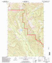
1994 Map of Upper Whitefish Lake
USGS Topo · Published 1997About this map
Upper Whitefish Lake sits at the heart of this mid-1990s survey, marking a significant hydrological point where the West Fork and East Fork converge. The landscape is defined by the high elevations of the Whitefish Range, with prominent peaks like Diamond Pk and Antice Point overlooking the surrounding wilderness. This map illustrates the administrative division between the Flathead National Forest and the Stillwater State Forest, capturing the network of drainage basins including Swift Creek, Antice Creek, and Hay Creek. Human passage through this steep terrain is documented by the Thayer Memorial Trail and the Glacier Tally Lake View Rd, which provides access to the remote Haines Pass. The map serves as a detailed record of the forest management boundaries and natural landmarks like Stryker Ridge and Coal Ridge during this era of conservation.
Find a feature on this map
27 named features on this map. Tap any name to fly to it.
Don’t see what you’re looking for? This feature index may not catch every label — zoom into the map to look around manually.
Map Details
Editions of this 1994 Upper Whitefish Lake Map
This is the sole edition of this map. No revisions or reprints were ever made.
Other maps of this area

1906 · Kintla Lakes
USGS Topo · 1:125,000

1913 · Stryker
USGS Topo · 1:125,000

1916 · Stryker
USGS Topo · 1:125,000

1938 · Kintla Lakes
USGS Topo · 1:125,000

1957 · Kalispell
USGS Topo · 1:250,000

1960 · Kalispell
USGS Topo · 1:250,000

1961 · Kalispell
USGS Topo · 1:250,000
1966 · Radnor
USGS Topo · 1:24,000

1966 · Red Meadow Lake
USGS Topo · 1:24,000
1966 · Bull Lake
USGS Topo · 1:24,000