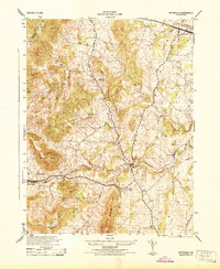
1944 Map of Upperville
USGS Topo · Published 1944About this map
Upperville anchors the northeastern corner of this wartime landscape where the Piedmont meets the rising slopes of the Blue Ridge. The geography is defined by a series of prominent ridges, including Little Cobbler Mtn, Naked Mtn, and Lost Mountain, which channel the local transport and water systems. Along the southern corridor, the Southern railroad connects the mountain gap at Markham to the community of Delaplane, following the path of Goose Creek.
Find a feature on this map
22 named features on this map. Tap any name to fly to it.
Don’t see what you’re looking for? This feature index may not catch every label — zoom into the map to look around manually.
Map Details
Editions of this 1944 Upperville Map
This is the sole edition of this map. No revisions or reprints were ever made.
Other maps of this area

1884 · Harpers Ferry
USGS Topo · 1:125,000

1891 · Harpers Ferry
USGS Topo · 1:125,000

1893 · Luray
USGS Topo · 1:125,000

1893 · Harpers Ferry
USGS Topo · 1:125,000

1894 · Warrenton
USGS Topo · 1:125,000

1894 · Winchester
USGS Topo · 1:125,000

1905 · Luray
USGS Topo · 1:125,000

1916 · Berryville
USGS Topo · 1:62,500

1938 · Winchester
USGS Topo · 1:48,000

1939 · Front Royal
USGS Topo · 1:48,000