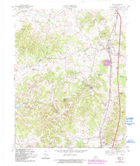
1967 Map of Upton
USGS Topo · Published 1993About this map
Upton serves as a primary hub where the Louisville and Nashville railroad tracks and the Kentucky Turnpike meet, marking a point of transition between the rolling uplands and the deeply dissected karst landscape to the south. The terrain is characterized by a dense network of sinks and springs, such as Roaring Spring, Blue Hole Spring, and Falling Spring, which feed into the rugged drainages of Bacon Creek and Sandy Valley Creek. The rural settlement pattern of the mid-twentieth century is well-preserved here, with small communities like Melrose, Lone Star, and Bonnieville dotting the landscape. Genealogy researchers will find significant value in the documentation of several family-named landmarks and country churches, including Bethel Ch, Zion Ch, and the Brackett Cem. To the southwest, the emergence of Nolin Lake and the site of Riders Mill reflect the area's relationship with its water resources during this era of development.
Find a feature on this map
48 named features on this map. Tap any name to fly to it.
Don’t see what you’re looking for? This feature index may not catch every label — zoom into the map to look around manually.
Map Details
Editions of this 1967 Upton Map
2 editions found
Other maps of this area

1925 · Cub Run
USGS Topo · 1:62,500

1932 · Big Clifty
USGS Topo · 1:62,500

1934 · Munfordville
USGS Topo · 1:48,000

1935 · Elizabethtown
USGS Topo · 1:48,000

1937 · Munfordville
USGS Topo · 1:62,500

1938 · Elizabethtown
USGS Topo · 1:62,500

1949 · Sonora
USGS Topo · 1:24,000

1949 · Tonieville
USGS Topo · 1:24,000

1949 · Summit
USGS Topo · 1:24,000

1949 · Big Clifty
USGS Topo · 1:62,500