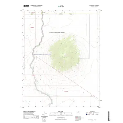
2020 Map of Ute Mountain
USGS Topo · Published 2020About this map
Ute Mtn dominates the high-altitude volcanic landscape of northern Taos County, rising from the plateau within the Río Grande del Norte National Monument. The western boundary of the sheet is defined by the dramatic incision of the Cañon del Rio Grande, where the river is protected as the Rio Grande, New Mexico Wild and Scenic River. This modern survey illustrates the rugged intersection of the New Mexico and Colorado state line, where the high desert terrain is marked by seasonal drainages like Costilla Cr. Human presence in this protected wilderness is traced primarily through the E Rim Trail, which follows the precipice of the gorge, offering a contemporary look at one of the most significant geologic features in the American Southwest.
Find a feature on this map
17 named features on this map. Tap any name to fly to it.
Don’t see what you’re looking for? This feature index may not catch every label — zoom into the map to look around manually.
Map Details
Editions of this 2020 Ute Mountain Map
This is the sole edition of this map. No revisions or reprints were ever made.
Other maps of this area

1954 · Raton
USGS Topo · 1:250,000

1954 · Trinidad
USGS Topo · 1:250,000

1955 · Trinidad
USGS Topo · 1:250,000

1958 · Raton
USGS Topo · 1:250,000

1958 · Trinidad
USGS Topo · 1:250,000

1959 · Trinidad
USGS Topo · 1:250,000

1963 · Costilla
USGS Topo · 1:24,000

1963 · Cerro De La Olla
USGS Topo · 1:24,000

1963 · Cerro
USGS Topo · 1:24,000

1963 · Ute Mountain
USGS Topo · 1:24,000