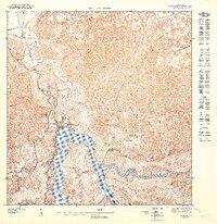
1947 Map of Utuado NE
USGS Topo · Published 1947About this map
The Planta Hidroeléctrica marks a significant industrial presence where the Río Grande De Arecibo meets the northern expanse of Lago Dos Bocas. This 1943 topography, published in 1947, illustrates the intersection of mountainous terrain and strategic water management along the border of Arecibo and Utuado. The landscape is defined by the dense forestation of the Bosque De Guajataca and a network of rural settlements connected by the Insular road system. Local community life is centered around rural educational hubs like Escuela Del Valle and Escuela Jovales. The confluence of the Rio Limon and the main river channel creates a complex shoreline of inlets and ridges, supporting small clusters of habitations such as Dos Bocas and Los Muertos. These features offer a detailed perspective on mid-century infrastructure and social geography in the Puerto Rican interior.
Find a feature on this map
17 named features on this map. Tap any name to fly to it.
Don’t see what you’re looking for? This feature index may not catch every label — zoom into the map to look around manually.
Map Details
Editions of this 1947 Utuado NE Map
This is the sole edition of this map. No revisions or reprints were ever made.
Other maps of this area

1942 · Arecibo
USGS Topo · 1:30,000

1942 · Barceloneta
USGS Topo · 1:30,000

1943 · Utuado NE
USGS Topo · 1:10,000

1946 · Barceloneta
USGS Topo · 1:30,000

1946 · Utuado
USGS Topo · 1:30,000

1946 · Arecibo
USGS Topo · 1:30,000

1946 · Florida
USGS Topo · 1:30,000
1947 · Barceloneta SO
USGS Topo · 1:10,000
1947 · Utuado SE
USGS Topo · 1:10,000
1947 · Florida NO
USGS Topo · 1:10,000