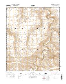
2014 Map of Utukok River C-1 NE
USGS Topo · Published 2014About this map
The Ketik River winds through the northernmost reaches of Alaska in this 2014 survey. Located in the North Slope Borough, the landscape is defined by the rhythmic turns of the river as it moves through the Public Land Survey System divisions of T5N, T4N, and T3N. The map reveals the stark topography of the arctic coastal plain, where the lack of permanent settlements or roads emphasizes the isolation of the Ketik River drainage system. This survey provides a baseline for the region's hydrography and elevation, documenting the subtle shifts in the river's path through the tundra before any significant modern development or alteration.
Find a feature on this map
7 named features on this map. Tap any name to fly to it.
Don’t see what you’re looking for? This feature index may not catch every label — zoom into the map to look around manually.
Map Details
Editions of this 2014 Utukok River C-1 NE Map
This is the sole edition of this map. No revisions or reprints were ever made.
Other maps of this area

1951 · Utukok River
USGS Topo · 1:250,000

1951 · Lookout Ridge
USGS Topo · 1:250,000

1956 · Lookout Ridge
USGS Topo · 1:250,000

1956 · Utukok River
USGS Topo · 1:250,000

1965 · Utukok River
USGS Topo · 1:250,000
1984 · Lookout Ridge D-5
USGS Topo · 1:63,360
1984 · Lookout Ridge C-5
USGS Topo · 1:63,360
1984 · Utukok River D-1
USGS Topo · 1:63,360
1984 · Utukok River C-1
USGS Topo · 1:63,360
2014 · Utukok River C-1 SW
USGS Topo · 1:25,000