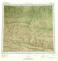
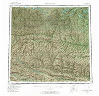
1956 Map of Lookout Ridge
USGS Topo · Published 1959About this map
Naval Petroleum Reserve No 4 dominates the central landscape of this mid-century survey, a vast expanse of the North Slope defined by its complex drainage systems and prominent structural ridges. The topography is anchored by the east-west trending Lookout Ridge and Shaningarok Ridge, which dictate the paths of numerous waterways such as the Awuna River and the Meade River. The presence of several Tractor Trails cutting across the tundra suggests the era's early industrial and scientific exploration for oil resources.
Find a feature on this map
62 named features on this map. Tap any name to fly to it.
Don’t see what you’re looking for? This feature index may not catch every label — zoom into the map to look around manually.
Map Details
Editions of this 1956 Lookout Ridge Map
5 editions found
Historical Maps of North Slope Through Time
2482 maps found

1945 Barrow
North Slope Borough, AK

1949 Barrow
North Slope Borough, AK

1951 Arctic
North Slope Borough, AK

1951 Barter Island
North Slope Borough, AK

1951 Beechey Point
North Slope Borough, AK

1951 De Long Mountains
North Slope Borough, AK

1951 Demarcation Point
North Slope Borough, AK

1951 Harrison Bay
North Slope Borough, AK

1951 Howard Pass
North Slope Borough, AK

1951 Ikpikpuk River
North Slope Borough, AK

1951 Killik River
North Slope Borough, AK

1951 Lookout Ridge
North Slope Borough, AK

1951 Meade River
North Slope Borough, AK

1951 Misheguk Mountain
North Slope Borough, AK

1951 Mt. Michelson
North Slope Borough, AK

1951 Sagavanirktok D-5
North Slope Borough, AK

1951 Teshekpuk
North Slope Borough, AK

1951 Utukok River
North Slope Borough, AK

1952 Point Hope A-2
North Slope Borough, AK

1952 Point Hope B-3
North Slope Borough, AK

1952 Point Hope C-3
North Slope Borough, AK

1952 Point Hope D-1
North Slope Borough, AK

1952 Point Hope D-2
North Slope Borough, AK

1952 Umiat
North Slope Borough, AK

1955 Barrow A-1
North Slope Borough, AK

1955 Barrow A-2
North Slope Borough, AK

1955 Barrow A-3
North Slope Borough, AK

1955 Barrow A-4
North Slope Borough, AK

1955 Barrow A-5
North Slope Borough, AK

1955 Barrow B-3
North Slope Borough, AK

1955 Barrow B-4
North Slope Borough, AK

1955 Barrow
North Slope Borough, AK

1955 Barter Island A-3
North Slope Borough, AK

1955 Barter Island A-4
North Slope Borough, AK

1955 Barter Island A-5
North Slope Borough, AK

1955 Beechey Point A-1
North Slope Borough, AK

1955 Beechey Point A-2
North Slope Borough, AK

1955 Beechey Point A-3
North Slope Borough, AK

1955 Beechey Point A-4
North Slope Borough, AK

1955 Beechey Point A-5
North Slope Borough, AK

1955 Beechey Point B-1
North Slope Borough, AK

1955 Beechey Point B-2
North Slope Borough, AK

1955 Beechey Point B-3
North Slope Borough, AK

1955 Beechey Point B-4
North Slope Borough, AK

1955 Beechey Point C-4
North Slope Borough, AK

1955 Beechey Point C-5
North Slope Borough, AK

1955 Beechey Point
North Slope Borough, AK

1955 De Long Mountains A-5
North Slope Borough, AK

1955 De Long Mountains B-1
North Slope Borough, AK

1955 De Long Mountains B-2
North Slope Borough, AK

1955 De Long Mountains B-3
North Slope Borough, AK

1955 De Long Mountains B-4
North Slope Borough, AK

1955 De Long Mountains B-5
North Slope Borough, AK

1955 De Long Mountains C-1
North Slope Borough, AK

1955 De Long Mountains C-2
North Slope Borough, AK

1955 De Long Mountains C-3
North Slope Borough, AK

1955 De Long Mountains C-4
North Slope Borough, AK

1955 De Long Mountains C-5
North Slope Borough, AK

1955 De Long Mountains D-1
North Slope Borough, AK

1955 De Long Mountains D-2
North Slope Borough, AK

1955 De Long Mountains D-3
North Slope Borough, AK

1955 De Long Mountains D-4
North Slope Borough, AK

1955 De Long Mountains D-5
North Slope Borough, AK

1955 De Long Mountains
North Slope Borough, AK

1955 Demarcation Point C-1
North Slope Borough, AK

1955 Demarcation Point C-2
North Slope Borough, AK

1955 Demarcation Point C-3
North Slope Borough, AK

1955 Demarcation Point C-4
North Slope Borough, AK

1955 Demarcation Point C-5
North Slope Borough, AK

1955 Demarcation Point D-2
North Slope Borough, AK

1955 Demarcation Point D-3
North Slope Borough, AK

1955 Demarcation Point D-4
North Slope Borough, AK

1955 Demarcation Point D-5
North Slope Borough, AK

1955 Demarcation Point
North Slope Borough, AK

1955 Flaxman Island A-1
North Slope Borough, AK

1955 Flaxman Island A-3
North Slope Borough, AK

1955 Flaxman Island A-4
North Slope Borough, AK

1955 Flaxman Island A-5
North Slope Borough, AK

1955 Flaxman Island B-5
North Slope Borough, AK

1955 Flaxman Island
North Slope Borough, AK

1955 Harrison Bay A-1
North Slope Borough, AK

1955 Harrison Bay A-2
North Slope Borough, AK

1955 Harrison Bay A-3
North Slope Borough, AK

1955 Harrison Bay A-4
North Slope Borough, AK

1955 Harrison Bay A-5
North Slope Borough, AK

1955 Harrison Bay B-1
North Slope Borough, AK

1955 Harrison Bay B-2
North Slope Borough, AK

1955 Harrison Bay B-3
North Slope Borough, AK

1955 Harrison Bay B-4
North Slope Borough, AK

1955 Harrison Bay B-5
North Slope Borough, AK

1955 Harrison Bay C-1
North Slope Borough, AK

1955 Harrison Bay C-3
North Slope Borough, AK

1955 Harrison Bay C-4
North Slope Borough, AK

1955 Harrison Bay C-5
North Slope Borough, AK

1955 Harrison Bay D-4
North Slope Borough, AK

1955 Harrison Bay D-5
North Slope Borough, AK

1955 Harrison Bay
North Slope Borough, AK

1955 Meade River A-1
North Slope Borough, AK

1955 Meade River A-2
North Slope Borough, AK

1955 Meade River A-3
North Slope Borough, AK

1955 Meade River A-4
North Slope Borough, AK

1955 Meade River A-5
North Slope Borough, AK

1955 Meade River B-1
North Slope Borough, AK

1955 Meade River B-2
North Slope Borough, AK

1955 Meade River B-3
North Slope Borough, AK

1955 Meade River B-4
North Slope Borough, AK

1955 Meade River B-5
North Slope Borough, AK

1955 Meade River C-1
North Slope Borough, AK

1955 Meade River C-2
North Slope Borough, AK

1955 Meade River C-3
North Slope Borough, AK

1955 Meade River C-4
North Slope Borough, AK

1955 Meade River C-5
North Slope Borough, AK

1955 Meade River D-1
North Slope Borough, AK

1955 Meade River D-2
North Slope Borough, AK

1955 Meade River D-3
North Slope Borough, AK

1955 Meade River D-4
North Slope Borough, AK

1955 Meade River D-5
North Slope Borough, AK

1955 Meade River
North Slope Borough, AK

1955 Mount Michelson B-1
North Slope Borough, AK

1955 Mount Michelson C-2
North Slope Borough, AK

1955 Mount Michelson C-3
North Slope Borough, AK

1955 Mount Michelson C-4
North Slope Borough, AK

1955 Mount Michelson C-5
North Slope Borough, AK

1955 Mount Michelson D-2
North Slope Borough, AK

1955 Mount Michelson D-3
North Slope Borough, AK

1955 Mt. Michelson C-1
North Slope Borough, AK

1955 Mt. Michelson D-1
North Slope Borough, AK

1955 Mt. Michelson D-4
North Slope Borough, AK

1955 Mt. Michelson D-5
North Slope Borough, AK

1955 Point Hope A-1
North Slope Borough, AK

1955 Point Hope B-1
North Slope Borough, AK

1955 Point Hope B-2
North Slope Borough, AK

1955 Point Hope C-1
North Slope Borough, AK

1955 Point Hope C-2
North Slope Borough, AK

1955 Point Lay A-1
North Slope Borough, AK

1955 Point Lay A-2
North Slope Borough, AK

1955 Point Lay A-3 and A-4
North Slope Borough, AK

1955 Point Lay B-1
North Slope Borough, AK

1955 Point Lay B-2 and B-3
North Slope Borough, AK

1955 Point Lay C-1
North Slope Borough, AK

1955 Point Lay C-2
North Slope Borough, AK

1955 Point Lay D-1
North Slope Borough, AK

1955 Point Lay D-2
North Slope Borough, AK

1955 Sagavanirktok C-1
North Slope Borough, AK

1955 Sagavanirktok D-1
North Slope Borough, AK

1955 Sagavanirktok D-2
North Slope Borough, AK

1955 Sagavanirktok D-3
North Slope Borough, AK

1955 Sagavanirktok D-4
North Slope Borough, AK

1955 Sagavanirktok D-5
North Slope Borough, AK

1955 Teshekpuk A-1
North Slope Borough, AK

1955 Teshekpuk A-2
North Slope Borough, AK

1955 Teshekpuk A-3
North Slope Borough, AK

1955 Teshekpuk A-4
North Slope Borough, AK

1955 Teshekpuk A-5
North Slope Borough, AK

1955 Teshekpuk B-1
North Slope Borough, AK

1955 Teshekpuk B-2
North Slope Borough, AK

1955 Teshekpuk B-3
North Slope Borough, AK

1955 Teshekpuk B-4
North Slope Borough, AK

1955 Teshekpuk B-5
North Slope Borough, AK

1955 Teshekpuk C-1
North Slope Borough, AK

1955 Teshekpuk C-2
North Slope Borough, AK

1955 Teshekpuk C-3
North Slope Borough, AK

1955 Teshekpuk C-4
North Slope Borough, AK

1955 Teshekpuk C-5
North Slope Borough, AK

1955 Teshekpuk D-1
North Slope Borough, AK

1955 Teshekpuk D-2
North Slope Borough, AK

1955 Teshekpuk D-3
North Slope Borough, AK

1955 Teshekpuk D-4
North Slope Borough, AK

1955 Teshekpuk D-5
North Slope Borough, AK

1955 Teshekpuk
North Slope Borough, AK

1955 Umiat A-3
North Slope Borough, AK

1955 Umiat A-4
North Slope Borough, AK

1955 Umiat A-5
North Slope Borough, AK

1955 Umiat B-3
North Slope Borough, AK

1955 Umiat B-4
North Slope Borough, AK

1955 Umiat B-5
North Slope Borough, AK

1955 Umiat C-3
North Slope Borough, AK

1955 Umiat C-4
North Slope Borough, AK

1955 Umiat C-5
North Slope Borough, AK

1955 Umiat D-1
North Slope Borough, AK

1955 Umiat D-2
North Slope Borough, AK

1955 Umiat D-3
North Slope Borough, AK

1955 Umiat D-4
North Slope Borough, AK

1955 Umiat D-5
North Slope Borough, AK

1955 Utukok River A-3
North Slope Borough, AK

1955 Utukok River A-4
North Slope Borough, AK

1955 Utukok River A-5
North Slope Borough, AK

1955 Utukok River B-3
North Slope Borough, AK

1955 Utukok River B-4
North Slope Borough, AK

1955 Utukok River B-5
North Slope Borough, AK

1955 Utukok River C-3
North Slope Borough, AK

1955 Utukok River C-4
North Slope Borough, AK

1955 Utukok River C-5
North Slope Borough, AK

1955 Utukok River D-3
North Slope Borough, AK

1955 Utukok River D-4
North Slope Borough, AK

1955 Utukok River D-5
North Slope Borough, AK

1955 Wainwright A-1
North Slope Borough, AK

1955 Wainwright A-2
North Slope Borough, AK

1955 Wainwright A-3
North Slope Borough, AK

1955 Wainwright A-4
North Slope Borough, AK

1955 Wainwright A-5
North Slope Borough, AK

1955 Wainwright A-6 and A-7
North Slope Borough, AK

1955 Wainwright B-1
North Slope Borough, AK

1955 Wainwright B-2
North Slope Borough, AK

1955 Wainwright B-3
North Slope Borough, AK

1955 Wainwright B-4
North Slope Borough, AK

1955 Wainwright B-5 and B-6
North Slope Borough, AK

1955 Wainwright C-1
North Slope Borough, AK

1955 Wainwright C-2
North Slope Borough, AK

1955 Wainwright C-3
North Slope Borough, AK

1955 Wainwright D-1
North Slope Borough, AK

1955 Wainwright D-2
North Slope Borough, AK

1956 Arctic
North Slope Borough, AK

1956 Demarcation Point B-1
North Slope Borough, AK

1956 Demarcation Point B-2
North Slope Borough, AK

1956 Demarcation Point B-3
North Slope Borough, AK

1956 Demarcation Point B-4
North Slope Borough, AK

1956 Demarcation Point B-5
North Slope Borough, AK

1956 Howard Pass
North Slope Borough, AK

1956 Ikpikpuk River
North Slope Borough, AK

1956 Killik River
North Slope Borough, AK

1956 Lookout Ridge
North Slope Borough, AK

1956 Misheguk Mountain
North Slope Borough, AK

1956 Mount Michelson B-2
North Slope Borough, AK

1956 Mount Michelson B-3
North Slope Borough, AK

1956 Mt. Michelson
North Slope Borough, AK

1956 Point Lay A-2
North Slope Borough, AK

1956 Sagavanirktok
North Slope Borough, AK

1956 Umiat
North Slope Borough, AK

1956 Utukok River
North Slope Borough, AK

1958 Sagavanirktok
North Slope Borough, AK

1959 Barter Island
North Slope Borough, AK

1960 Beechey Point
North Slope Borough, AK

1962 Barrow A-1
North Slope Borough, AK

1962 Barrow A-4
North Slope Borough, AK

1962 Barrow B-4
North Slope Borough, AK

1962 Beechey Point A-1
North Slope Borough, AK

1962 Beechey Point A-2
North Slope Borough, AK

1962 Beechey Point B-1
North Slope Borough, AK

1962 Beechey Point B-2
North Slope Borough, AK

1962 Beechey Point B-4
North Slope Borough, AK

1962 Beechey Point C-4
North Slope Borough, AK

1962 Demarcation Point D-3
North Slope Borough, AK

1962 Flaxman Island A-1
North Slope Borough, AK

1962 Flaxman Island A-4
North Slope Borough, AK

1962 Flaxman Island A-5
North Slope Borough, AK

1962 Harrison Bay B-1
North Slope Borough, AK

1962 Harrison Bay B-2
North Slope Borough, AK

1962 Harrison Bay B-3
North Slope Borough, AK

1962 Harrison Bay C-1
North Slope Borough, AK

1962 Harrison Bay C-3
North Slope Borough, AK

1962 Harrison Bay C-5
North Slope Borough, AK

1962 Harrison Bay D-4
North Slope Borough, AK

1962 Harrison Bay D-5
North Slope Borough, AK

1962 Meade River C-4
North Slope Borough, AK

1962 Meade River C-5
North Slope Borough, AK

1962 Meade River D-2
North Slope Borough, AK

1962 Meade River D-3
North Slope Borough, AK

1962 Meade River D-4
North Slope Borough, AK

1962 Meade River D-5
North Slope Borough, AK

1962 Mt. Michelson D-1
North Slope Borough, AK

1962 Teshekpuk C-2
North Slope Borough, AK

1962 Wainwright D-2
North Slope Borough, AK

1964 Barter Island
North Slope Borough, AK

1964 Beechey Point
North Slope Borough, AK

1964 Demarcation Point
North Slope Borough, AK

1964 Sagavanirktok
North Slope Borough, AK

1964 Teshekpuk
North Slope Borough, AK

1964 Umiat
North Slope Borough, AK

1965 De Long Mountains
North Slope Borough, AK

1965 Utukok River
North Slope Borough, AK

1970 Beechey Point A-2 NE
North Slope Borough, AK

1970 Beechey Point A-2 NW
North Slope Borough, AK

1970 Beechey Point A-3 NE
North Slope Borough, AK

1970 Beechey Point A-3 NW
North Slope Borough, AK

1970 Beechey Point A-4 NE
North Slope Borough, AK

1970 Beechey Point B-2 SE
North Slope Borough, AK

1970 Beechey Point B-2 SW
North Slope Borough, AK

1970 Beechey Point B-3 NW
North Slope Borough, AK

1970 Beechey Point B-3 SE
North Slope Borough, AK

1970 Beechey Point B-3 SW
North Slope Borough, AK

1970 Beechey Point B-4 NE
North Slope Borough, AK

1970 Beechey Point B-4 SE
North Slope Borough, AK

1971 Arctic C-5
North Slope Borough, AK

1971 Arctic D-5
North Slope Borough, AK

1971 Chandler Lake A-1
North Slope Borough, AK

1971 Chandler Lake A-2
North Slope Borough, AK

1971 Chandler Lake A-3
North Slope Borough, AK

1971 Chandler Lake B-1
North Slope Borough, AK

1971 Chandler Lake B-2
North Slope Borough, AK

1971 Chandler Lake C-1
North Slope Borough, AK

1971 Chandler Lake C-2
North Slope Borough, AK

1971 Chandler Lake D-1
North Slope Borough, AK

1971 Chandler Lake D-2
North Slope Borough, AK

1971 Mount Michelson A-5
North Slope Borough, AK

1971 Mount Michelson B-5
North Slope Borough, AK

1971 Philip Smith Mountains A-1
North Slope Borough, AK

1971 Philip Smith Mountains A-2
North Slope Borough, AK

1971 Philip Smith Mountains A-3
North Slope Borough, AK

1971 Philip Smith Mountains A-4
North Slope Borough, AK

1971 Philip Smith Mountains A-5
North Slope Borough, AK

1971 Philip Smith Mountains B-1
North Slope Borough, AK

1971 Philip Smith Mountains B-2
North Slope Borough, AK

1971 Philip Smith Mountains B-3
North Slope Borough, AK

1971 Philip Smith Mountains B-4
North Slope Borough, AK

1971 Philip Smith Mountains B-5
North Slope Borough, AK

1971 Philip Smith Mountains C-1
North Slope Borough, AK

1971 Philip Smith Mountains C-2
North Slope Borough, AK

1971 Philip Smith Mountains C-3
North Slope Borough, AK

1971 Philip Smith Mountains C-4
North Slope Borough, AK

1971 Philip Smith Mountains C-5
North Slope Borough, AK

1971 Philip Smith Mountains D-1
North Slope Borough, AK

1971 Philip Smith Mountains D-2
North Slope Borough, AK

1971 Philip Smith Mountains D-3
North Slope Borough, AK

1971 Philip Smith Mountains D-4
North Slope Borough, AK

1971 Philip Smith Mountains D-5
North Slope Borough, AK

1971 Sagavanirktok A-1
North Slope Borough, AK

1971 Sagavanirktok A-2
North Slope Borough, AK

1971 Sagavanirktok A-3
North Slope Borough, AK

1971 Sagavanirktok A-4
North Slope Borough, AK

1971 Sagavanirktok A-5
North Slope Borough, AK

1971 Sagavanirktok B-1
North Slope Borough, AK

1971 Sagavanirktok B-2
North Slope Borough, AK

1971 Sagavanirktok B-3
North Slope Borough, AK

1971 Sagavanirktok B-4
North Slope Borough, AK

1971 Sagavanirktok B-5
North Slope Borough, AK

1971 Sagavanirktok C-2
North Slope Borough, AK

1971 Sagavanirktok C-3
North Slope Borough, AK

1971 Sagavanirktok C-4
North Slope Borough, AK

1971 Sagavanirktok C-5
North Slope Borough, AK

1971 Umiat A-1
North Slope Borough, AK

1971 Umiat A-2
North Slope Borough, AK

1971 Umiat B-1
North Slope Borough, AK

1971 Umiat B-2
North Slope Borough, AK

1971 Umiat C-1
North Slope Borough, AK

1971 Umiat C-2
North Slope Borough, AK

1972 Arctic A-4
North Slope Borough, AK

1972 Arctic A-5
North Slope Borough, AK

1973 Barrow B-4
North Slope Borough, AK

1973 Mount Michelson C-5
North Slope Borough, AK

1975 Mount Michelson C-3
North Slope Borough, AK

1978 Mount Michelson C-4
North Slope Borough, AK

1981 Arctic B-5
North Slope Borough, AK

1982 Teshekpuk B-2
North Slope Borough, AK

1983 Arctic B-4
North Slope Borough, AK

1983 Arctic C-1
North Slope Borough, AK

1983 Arctic C-2
North Slope Borough, AK

1983 Arctic C-3
North Slope Borough, AK

1983 Arctic C-4
North Slope Borough, AK

1983 Arctic D-1
North Slope Borough, AK

1983 Arctic D-2
North Slope Borough, AK

1983 Arctic D-3
North Slope Borough, AK

1983 Arctic D-4
North Slope Borough, AK

1983 Demarcation Point A-1
North Slope Borough, AK

1983 Demarcation Point A-2
North Slope Borough, AK

1983 Demarcation Point A-3
North Slope Borough, AK

1983 Demarcation Point A-4
North Slope Borough, AK

1983 Demarcation Point A-5
North Slope Borough, AK

1983 Mount Michelson A-3
North Slope Borough, AK

1983 Mt. Michelson A-1
North Slope Borough, AK

1983 Mt. Michelson A-2
North Slope Borough, AK

1983 Mt. Michelson A-4
North Slope Borough, AK

1983 Mt. Michelson B-4
North Slope Borough, AK

1983 Table Mountain C-1
North Slope Borough, AK

1983 Table Mountain C-2
North Slope Borough, AK

1983 Table Mountain C-3
North Slope Borough, AK

1983 Table Mountain C-4
North Slope Borough, AK

1983 Table Mountain C-5
North Slope Borough, AK

1983 Table Mountain D-1
North Slope Borough, AK

1983 Table Mountain D-2
North Slope Borough, AK

1983 Table Mountain D-3
North Slope Borough, AK

1983 Table Mountain D-4
North Slope Borough, AK

1983 Table Mountain D-5
North Slope Borough, AK

1984 Howard Pass A-1
North Slope Borough, AK

1984 Howard Pass B-1
North Slope Borough, AK

1984 Howard Pass B-2
North Slope Borough, AK

1984 Howard Pass B-3
North Slope Borough, AK

1984 Howard Pass B-4
North Slope Borough, AK

1984 Howard Pass B-5
North Slope Borough, AK

1984 Howard Pass C-1
North Slope Borough, AK

1984 Howard Pass C-2
North Slope Borough, AK

1984 Howard Pass C-3
North Slope Borough, AK

1984 Howard Pass C-4
North Slope Borough, AK

1984 Howard Pass C-5
North Slope Borough, AK

1984 Howard Pass D-1
North Slope Borough, AK

1984 Howard Pass D-2
North Slope Borough, AK

1984 Howard Pass D-3
North Slope Borough, AK

1984 Howard Pass D-4
North Slope Borough, AK

1984 Howard Pass D-5
North Slope Borough, AK

1984 Ikpikpuk River A-1
North Slope Borough, AK

1984 Ikpikpuk River A-2
North Slope Borough, AK

1984 Ikpikpuk River A-3
North Slope Borough, AK

1984 Ikpikpuk River A-4
North Slope Borough, AK

1984 Ikpikpuk River A-5
North Slope Borough, AK

1984 Ikpikpuk River D-1
North Slope Borough, AK

1984 Ikpikpuk River D-2
North Slope Borough, AK

1984 Ikpikpuk River D-3
North Slope Borough, AK

1984 Ikpikpuk River D-5
North Slope Borough, AK

1984 Killik River A-5
North Slope Borough, AK

1984 Killik River B-5
North Slope Borough, AK

1984 Killik River C-5
North Slope Borough, AK

1984 Killik River D-2
North Slope Borough, AK

1984 Killik River D-5
North Slope Borough, AK

1984 Lookout Ridge A-1
North Slope Borough, AK

1984 Lookout Ridge A-2
North Slope Borough, AK

1984 Lookout Ridge A-3
North Slope Borough, AK

1984 Lookout Ridge A-4
North Slope Borough, AK

1984 Lookout Ridge A-5
North Slope Borough, AK

1984 Lookout Ridge C-4
North Slope Borough, AK

1984 Lookout Ridge C-5
North Slope Borough, AK

1984 Lookout Ridge D-1
North Slope Borough, AK

1984 Lookout Ridge D-2
North Slope Borough, AK

1984 Lookout Ridge D-3
North Slope Borough, AK

1984 Lookout Ridge D-4
North Slope Borough, AK

1984 Lookout Ridge D-5
North Slope Borough, AK

1984 Misheguk Mountain C-1
North Slope Borough, AK

1984 Misheguk Mountain C-2
North Slope Borough, AK

1984 Misheguk Mountain C-3
North Slope Borough, AK

1984 Misheguk Mountain C-4
North Slope Borough, AK

1984 Misheguk Mountain C-5
North Slope Borough, AK

1984 Misheguk Mountain D-1
North Slope Borough, AK

1984 Misheguk Mountain D-2
North Slope Borough, AK

1984 Misheguk Mountain D-3
North Slope Borough, AK

1984 Misheguk Mountain D-4
North Slope Borough, AK

1984 Misheguk Mountain D-5
North Slope Borough, AK

1984 Utukok River A-1
North Slope Borough, AK

1984 Utukok River A-2
North Slope Borough, AK

1984 Utukok River C-1
North Slope Borough, AK

1984 Utukok River C-2
North Slope Borough, AK

1984 Utukok River D-1
North Slope Borough, AK

1984 Utukok River D-2
North Slope Borough, AK

1985 Ikpikpuk River B-1
North Slope Borough, AK

1985 Ikpikpuk River B-2
North Slope Borough, AK

1985 Ikpikpuk River B-3
North Slope Borough, AK

1985 Ikpikpuk River B-4
North Slope Borough, AK

1985 Ikpikpuk River B-5
North Slope Borough, AK

1985 Ikpikpuk River C-1
North Slope Borough, AK

1985 Ikpikpuk River C-2
North Slope Borough, AK

1985 Ikpikpuk River C-3
North Slope Borough, AK

1985 Ikpikpuk River C-4
North Slope Borough, AK

1985 Ikpikpuk River C-5
North Slope Borough, AK

1985 Ikpikpuk River D-4
North Slope Borough, AK

1985 Lookout Ridge B-1
North Slope Borough, AK

1985 Lookout Ridge B-2
North Slope Borough, AK

1985 Lookout Ridge B-3
North Slope Borough, AK

1985 Lookout Ridge B-4
North Slope Borough, AK

1985 Lookout Ridge B-5
North Slope Borough, AK

1985 Lookout Ridge C-1
North Slope Borough, AK

1985 Lookout Ridge C-2
North Slope Borough, AK

1985 Lookout Ridge C-3
North Slope Borough, AK

1985 Utukok River B-1
North Slope Borough, AK

1985 Utukok River B-2
North Slope Borough, AK

1986 Chandler Lake A-4
North Slope Borough, AK

1986 Chandler Lake A-5
North Slope Borough, AK

1986 Killik River A-1
North Slope Borough, AK

1986 Killik River A-2
North Slope Borough, AK

1986 Killik River A-3
North Slope Borough, AK

1986 Killik River A-4
North Slope Borough, AK

1986 Killik River B-1
North Slope Borough, AK

1986 Killik River B-2
North Slope Borough, AK

1986 Killik River B-3
North Slope Borough, AK

1986 Killik River B-4
North Slope Borough, AK

1986 Killik River C-1
North Slope Borough, AK

1986 Killik River C-2
North Slope Borough, AK

1986 Killik River C-3
North Slope Borough, AK

1986 Killik River C-4
North Slope Borough, AK

1986 Killik River D-1
North Slope Borough, AK

1986 Killik River D-3
North Slope Borough, AK

1986 Killik River D-4
North Slope Borough, AK

1987 Chandler Lake B-3
North Slope Borough, AK

1987 Chandler Lake B-4
North Slope Borough, AK

1987 Chandler Lake B-5
North Slope Borough, AK

1987 Chandler Lake C-3
North Slope Borough, AK

1987 Chandler Lake C-4
North Slope Borough, AK

1987 Chandler Lake C-5
North Slope Borough, AK

1987 Chandler Lake D-3
North Slope Borough, AK

1987 Chandler Lake D-4
North Slope Borough, AK

1987 Chandler Lake D-5
North Slope Borough, AK

1990 Misheguk Mountain B-1
North Slope Borough, AK

1990 Misheguk Mountain B-2
North Slope Borough, AK

1990 Misheguk Mountain B-3
North Slope Borough, AK

1990 Misheguk Mountain B-4
North Slope Borough, AK

1990 Misheguk Mountain B-5
North Slope Borough, AK

2013 Harrison Bay A-3 NE
North Slope Borough, AK

2013 Harrison Bay A-3 NW
North Slope Borough, AK

2013 Harrison Bay A-4 NE
North Slope Borough, AK

2013 Harrison Bay A-4 NW
North Slope Borough, AK

2013 Harrison Bay A-4 SE
North Slope Borough, AK

2013 Harrison Bay A-4 SW
North Slope Borough, AK

2013 Harrison Bay A-5 NE
North Slope Borough, AK

2013 Harrison Bay A-5 SE
North Slope Borough, AK

2013 Harrison Bay B-3 SW
North Slope Borough, AK

2013 Harrison Bay B-4 NW
North Slope Borough, AK

2013 Harrison Bay B-4 SE
North Slope Borough, AK

2013 Harrison Bay B-4 SW
North Slope Borough, AK

2013 Harrison Bay B-5 NE
North Slope Borough, AK

2013 Harrison Bay B-5 NW
North Slope Borough, AK

2013 Harrison Bay B-5 SE
North Slope Borough, AK

2013 Harrison Bay B-5 SW
North Slope Borough, AK

2013 Harrison Bay C-5 NW
North Slope Borough, AK

2013 Harrison Bay C-5 SW
North Slope Borough, AK

2013 Ikpikpuk River B-1 NE
North Slope Borough, AK

2013 Ikpikpuk River B-1 SW
North Slope Borough, AK

2013 Ikpikpuk River B-2 SE
North Slope Borough, AK

2013 Ikpikpuk River C-4 NE
North Slope Borough, AK

2013 Ikpikpuk River C-4 NW
North Slope Borough, AK

2013 Ikpikpuk River C-4 SW
North Slope Borough, AK

2013 Lookout Ridge B-3 NE
North Slope Borough, AK

2013 Lookout Ridge D-3 NE
North Slope Borough, AK

2013 Lookout Ridge D-3 NW
North Slope Borough, AK

2013 Lookout Ridge D-3 SE
North Slope Borough, AK

2013 Lookout Ridge D-3 SW
North Slope Borough, AK

2013 Meade River A-1 NW
North Slope Borough, AK

2013 Meade River A-2 NE
North Slope Borough, AK

2013 Meade River A-2 NW
North Slope Borough, AK

2013 Meade River A-3 NE
North Slope Borough, AK

2013 Meade River A-3 NW
North Slope Borough, AK

2013 Meade River A-3 SE
North Slope Borough, AK

2013 Meade River A-3 SW
North Slope Borough, AK

2013 Meade River B-1 SE
North Slope Borough, AK

2013 Meade River B-1 SW
North Slope Borough, AK

2013 Meade River B-2 SE
North Slope Borough, AK

2013 Meade River B-2 SW
North Slope Borough, AK

2013 Meade River B-3 NE
North Slope Borough, AK

2013 Meade River B-3 NW
North Slope Borough, AK

2013 Meade River B-3 SE
North Slope Borough, AK

2013 Meade River B-3 SW
North Slope Borough, AK

2013 Meade River C-3 NE
North Slope Borough, AK

2013 Meade River C-3 NW
North Slope Borough, AK

2013 Meade River C-3 SE
North Slope Borough, AK

2013 Meade River C-3 SW
North Slope Borough, AK

2013 Meade River D-2 NW
North Slope Borough, AK

2013 Meade River D-2 SW
North Slope Borough, AK

2013 Meade River D-3 SE
North Slope Borough, AK

2013 Teshekpuk A-3 NE
North Slope Borough, AK

2013 Teshekpuk A-3 NW
North Slope Borough, AK

2013 Teshekpuk A-3 SE
North Slope Borough, AK

2013 Teshekpuk A-3 SW
North Slope Borough, AK

2013 Teshekpuk B-1 NE
North Slope Borough, AK

2013 Teshekpuk B-1 NW
North Slope Borough, AK

2013 Teshekpuk B-1 SE
North Slope Borough, AK

2013 Teshekpuk B-1 SW
North Slope Borough, AK

2013 Teshekpuk B-2 NE
North Slope Borough, AK

2013 Teshekpuk B-2 NW
North Slope Borough, AK

2013 Teshekpuk B-2 SE
North Slope Borough, AK

2013 Teshekpuk B-2 SW
North Slope Borough, AK

2013 Teshekpuk B-3 NE
North Slope Borough, AK

2013 Teshekpuk B-3 NW
North Slope Borough, AK

2013 Teshekpuk B-3 SE
North Slope Borough, AK

2013 Teshekpuk B-3 SW
North Slope Borough, AK

2013 Teshekpuk B-4 NE
North Slope Borough, AK

2013 Teshekpuk B-4 NW
North Slope Borough, AK

2013 Teshekpuk B-4 SE
North Slope Borough, AK

2013 Teshekpuk B-4 SW
North Slope Borough, AK

2013 Teshekpuk B-5 NE
North Slope Borough, AK

2013 Teshekpuk B-5 NW
North Slope Borough, AK

2013 Teshekpuk B-5 SE
North Slope Borough, AK

2013 Teshekpuk B-5 SW
North Slope Borough, AK

2013 Teshekpuk C-1 NE
North Slope Borough, AK

2013 Teshekpuk C-1 NW
North Slope Borough, AK

2013 Teshekpuk C-1 SE
North Slope Borough, AK

2013 Teshekpuk C-1 SW
North Slope Borough, AK

2013 Teshekpuk C-2 NE
North Slope Borough, AK

2013 Teshekpuk C-2 NW
North Slope Borough, AK

2013 Teshekpuk C-2 SE
North Slope Borough, AK

2013 Teshekpuk C-2 SW
North Slope Borough, AK

2013 Teshekpuk C-3 NE
North Slope Borough, AK

2013 Teshekpuk C-3 NW
North Slope Borough, AK

2013 Teshekpuk C-3 SE
North Slope Borough, AK

2013 Teshekpuk C-3 SW
North Slope Borough, AK

2013 Teshekpuk C-4 NE
North Slope Borough, AK

2013 Teshekpuk C-4 NW
North Slope Borough, AK

2013 Teshekpuk C-4 SE
North Slope Borough, AK

2013 Teshekpuk C-4 SW
North Slope Borough, AK

2013 Teshekpuk C-5 SE
North Slope Borough, AK

2013 Teshekpuk C-5 SW
North Slope Borough, AK

2013 Teshekpuk D-1 SE
North Slope Borough, AK

2013 Teshekpuk D-4 NE
North Slope Borough, AK

2013 Teshekpuk D-4 SE
North Slope Borough, AK

2013 Teshekpuk D-4 SW
North Slope Borough, AK

2013 Umiat B-3 NE
North Slope Borough, AK

2013 Umiat B-3 NW
North Slope Borough, AK

2013 Umiat C-3 NE
North Slope Borough, AK

2013 Umiat C-3 NW
North Slope Borough, AK

2013 Umiat C-3 SE
North Slope Borough, AK

2013 Umiat C-3 SW
North Slope Borough, AK

2013 Umiat C-4 NE
North Slope Borough, AK

2013 Umiat C-4 NW
North Slope Borough, AK

2013 Umiat C-4 SE
North Slope Borough, AK

2013 Umiat C-4 SW
North Slope Borough, AK

2013 Umiat D-2 SW
North Slope Borough, AK

2013 Umiat D-3 NE
North Slope Borough, AK

2013 Umiat D-3 NW
North Slope Borough, AK

2013 Umiat D-3 SE
North Slope Borough, AK

2013 Umiat D-3 SW
North Slope Borough, AK

2013 Umiat D-4 NE
North Slope Borough, AK

2013 Umiat D-4 NW
North Slope Borough, AK

2013 Umiat D-4 SE
North Slope Borough, AK

2013 Umiat D-4 SW
North Slope Borough, AK

2014 De Long Mountains A-5 NE
North Slope Borough, AK

2014 De Long Mountains A-5 NW
North Slope Borough, AK

2014 De Long Mountains A-5 SE
North Slope Borough, AK

2014 De Long Mountains A-5 SW
North Slope Borough, AK

2014 De Long Mountains B-5 NE
North Slope Borough, AK

2014 De Long Mountains B-5 NW
North Slope Borough, AK

2014 De Long Mountains B-5 SE
North Slope Borough, AK

2014 De Long Mountains B-5 SW
North Slope Borough, AK

2014 De Long Mountains C-2 NW
North Slope Borough, AK

2014 De Long Mountains C-2 SW
North Slope Borough, AK

2014 De Long Mountains C-3 NE
North Slope Borough, AK

2014 De Long Mountains C-3 NW
North Slope Borough, AK

2014 De Long Mountains C-3 SE
North Slope Borough, AK

2014 De Long Mountains C-3 SW
North Slope Borough, AK

2014 De Long Mountains C-4 NE
North Slope Borough, AK

2014 De Long Mountains C-4 NW
North Slope Borough, AK

2014 De Long Mountains C-4 SE
North Slope Borough, AK

2014 De Long Mountains C-4 SW
North Slope Borough, AK

2014 De Long Mountains C-5 NE
North Slope Borough, AK

2014 De Long Mountains C-5 NW
North Slope Borough, AK

2014 De Long Mountains C-5 SE
North Slope Borough, AK

2014 De Long Mountains C-5 SW
North Slope Borough, AK

2014 De Long Mountains D-2 NE
North Slope Borough, AK

2014 De Long Mountains D-2 NW
North Slope Borough, AK

2014 De Long Mountains D-2 SW
North Slope Borough, AK

2014 De Long Mountains D-3 NE
North Slope Borough, AK

2014 De Long Mountains D-3 NW
North Slope Borough, AK

2014 De Long Mountains D-3 SE
North Slope Borough, AK

2014 De Long Mountains D-3 SW
North Slope Borough, AK

2014 De Long Mountains D-4 NE
North Slope Borough, AK

2014 De Long Mountains D-4 NW
North Slope Borough, AK

2014 De Long Mountains D-4 SE
North Slope Borough, AK

2014 De Long Mountains D-4 SW
North Slope Borough, AK

2014 De Long Mountains D-5 NE
North Slope Borough, AK

2014 De Long Mountains D-5 NW
North Slope Borough, AK

2014 De Long Mountains D-5 SE
North Slope Borough, AK

2014 De Long Mountains D-5 SW
North Slope Borough, AK

2014 Lookout Ridge B-4 NW
North Slope Borough, AK

2014 Lookout Ridge B-5 NE
North Slope Borough, AK

2014 Lookout Ridge B-5 NW
North Slope Borough, AK

2014 Lookout Ridge C-4 NW
North Slope Borough, AK

2014 Lookout Ridge C-4 SW
North Slope Borough, AK

2014 Lookout Ridge C-5 NE
North Slope Borough, AK

2014 Lookout Ridge C-5 NW
North Slope Borough, AK

2014 Lookout Ridge C-5 SE
North Slope Borough, AK

2014 Lookout Ridge C-5 SW
North Slope Borough, AK

2014 Lookout Ridge D-4 NW
North Slope Borough, AK

2014 Lookout Ridge D-4 SW
North Slope Borough, AK

2014 Lookout Ridge D-5 NE
North Slope Borough, AK

2014 Lookout Ridge D-5 NW
North Slope Borough, AK

2014 Lookout Ridge D-5 SE
North Slope Borough, AK

2014 Lookout Ridge D-5 SW
North Slope Borough, AK

2014 Meade River A-4 NE
North Slope Borough, AK

2014 Meade River A-4 NW
North Slope Borough, AK

2014 Meade River A-4 SE
North Slope Borough, AK

2014 Meade River A-4 SW
North Slope Borough, AK

2014 Meade River A-5 NE
North Slope Borough, AK

2014 Meade River A-5 NW
North Slope Borough, AK

2014 Meade River A-5 SE
North Slope Borough, AK

2014 Meade River A-5 SW
North Slope Borough, AK

2014 Meade River B-4 NE
North Slope Borough, AK

2014 Meade River B-4 NW
North Slope Borough, AK

2014 Meade River B-4 SE
North Slope Borough, AK

2014 Meade River B-4 SW
North Slope Borough, AK

2014 Meade River B-5 NE
North Slope Borough, AK

2014 Meade River B-5 NW
North Slope Borough, AK

2014 Meade River B-5 SE
North Slope Borough, AK

2014 Meade River B-5 SW
North Slope Borough, AK

2014 Meade River C-4 NE
North Slope Borough, AK

2014 Meade River C-4 NW
North Slope Borough, AK

2014 Meade River C-4 SE
North Slope Borough, AK

2014 Meade River C-4 SW
North Slope Borough, AK

2014 Meade River C-5 NE
North Slope Borough, AK

2014 Meade River C-5 NW
North Slope Borough, AK

2014 Meade River C-5 SE
North Slope Borough, AK

2014 Meade River C-5 SW
North Slope Borough, AK

2014 Meade River D-3 NE
North Slope Borough, AK

2014 Meade River D-3 NW
North Slope Borough, AK

2014 Meade River D-3 SW
North Slope Borough, AK

2014 Meade River D-4 SE
North Slope Borough, AK

2014 Meade River D-4 SW
North Slope Borough, AK

2014 Meade River D-5 NE
North Slope Borough, AK

2014 Meade River D-5 NW
North Slope Borough, AK

2014 Meade River D-5 SE
North Slope Borough, AK

2014 Meade River D-5 SW
North Slope Borough, AK

2014 Misheguk Mountain B-5 NE
North Slope Borough, AK

2014 Misheguk Mountain B-5 SE
North Slope Borough, AK

2014 Misheguk Mountain C-5 SE
North Slope Borough, AK

2014 Point Hope A-1 NE
North Slope Borough, AK

2014 Point Hope A-1 NW
North Slope Borough, AK

2014 Point Hope A-1 SE
North Slope Borough, AK

2014 Point Hope A-1 SW
North Slope Borough, AK

2014 Point Hope A-2 NE
North Slope Borough, AK

2014 Point Hope A-2 NW
North Slope Borough, AK

2014 Point Hope A-2 SE
North Slope Borough, AK

2014 Point Hope A-2 SW
North Slope Borough, AK

2014 Point Hope B-1 NE
North Slope Borough, AK

2014 Point Hope B-1 NW
North Slope Borough, AK

2014 Point Hope B-1 SE
North Slope Borough, AK

2014 Point Hope B-1 SW
North Slope Borough, AK

2014 Point Hope B-2 NE
North Slope Borough, AK

2014 Point Hope B-2 NW
North Slope Borough, AK

2014 Point Hope B-2 SE
North Slope Borough, AK

2014 Point Hope B-2 SW
North Slope Borough, AK

2014 Point Hope B-3 NE
North Slope Borough, AK

2014 Point Hope B-3 NW
North Slope Borough, AK

2014 Point Hope B-3 OE W SE
North Slope Borough, AK

2014 Point Hope B-3 SE
North Slope Borough, AK

2014 Point Hope B-3 SW
North Slope Borough, AK

2014 Point Hope C-1 NE
North Slope Borough, AK

2014 Point Hope C-1 NW
North Slope Borough, AK

2014 Point Hope C-1 SE
North Slope Borough, AK

2014 Point Hope C-1 SW
North Slope Borough, AK

2014 Point Hope C-2 NE
North Slope Borough, AK

2014 Point Hope C-2 NW
North Slope Borough, AK

2014 Point Hope C-2 SE
North Slope Borough, AK

2014 Point Hope C-2 SW
North Slope Borough, AK

2014 Point Hope C-3 NE
North Slope Borough, AK

2014 Point Hope C-3 SE
North Slope Borough, AK

2014 Point Hope D-1 NE
North Slope Borough, AK

2014 Point Hope D-1 SE
North Slope Borough, AK

2014 Point Hope D-1 SW
North Slope Borough, AK

2014 Point Hope D-2 NW
North Slope Borough, AK

2014 Point Hope D-2 OE W NE
North Slope Borough, AK

2014 Point Hope D-2 OE W SE
North Slope Borough, AK

2014 Point Hope D-2 SE
North Slope Borough, AK

2014 Point Hope D-2 SW
North Slope Borough, AK

2014 Point Lay A-1 NE
North Slope Borough, AK

2014 Point Lay A-1 NW
North Slope Borough, AK

2014 Point Lay A-2 NE
North Slope Borough, AK

2014 Point Lay A-2 NW
North Slope Borough, AK

2014 Point Lay A-2 SE
North Slope Borough, AK

2014 Point Lay A-2 SW
North Slope Borough, AK

2014 Point Lay A-3 NE
North Slope Borough, AK

2014 Point Lay A-3 NW
North Slope Borough, AK

2014 Point Lay A-3 SE
North Slope Borough, AK

2014 Point Lay A-3 SW
North Slope Borough, AK

2014 Point Lay A-4 SE
North Slope Borough, AK

2014 Point Lay B-1 NE
North Slope Borough, AK

2014 Point Lay B-1 NW
North Slope Borough, AK

2014 Point Lay B-1 SE
North Slope Borough, AK

2014 Point Lay B-1 SW
North Slope Borough, AK

2014 Point Lay B-2 NE
North Slope Borough, AK

2014 Point Lay B-2 NW
North Slope Borough, AK

2014 Point Lay B-2 SE
North Slope Borough, AK

2014 Point Lay B-2 SW
North Slope Borough, AK

2014 Point Lay B-3 SE
North Slope Borough, AK

2014 Point Lay C-1 NE
North Slope Borough, AK

2014 Point Lay C-1 NW
North Slope Borough, AK

2014 Point Lay C-1 SE
North Slope Borough, AK

2014 Point Lay C-1 SW
North Slope Borough, AK

2014 Point Lay C-2 NE
North Slope Borough, AK

2014 Point Lay C-2 NW
North Slope Borough, AK

2014 Point Lay C-2 SE
North Slope Borough, AK

2014 Point Lay C-2 SW
North Slope Borough, AK

2014 Point Lay D-1 NE
North Slope Borough, AK

2014 Point Lay D-1 NW
North Slope Borough, AK

2014 Point Lay D-1 SE
North Slope Borough, AK

2014 Point Lay D-1 SW
North Slope Borough, AK

2014 Point Lay D-2 NE
North Slope Borough, AK

2014 Point Lay D-2 SE
North Slope Borough, AK

2014 Point Lay D-2 SW
North Slope Borough, AK

2014 Utukok River B-1 NE
North Slope Borough, AK

2014 Utukok River B-1 NW
North Slope Borough, AK

2014 Utukok River B-2 NE
North Slope Borough, AK

2014 Utukok River B-2 NW
North Slope Borough, AK

2014 Utukok River B-3 NE
North Slope Borough, AK

2014 Utukok River B-4 NW
North Slope Borough, AK

2014 Utukok River B-5 NE
North Slope Borough, AK

2014 Utukok River B-5 NW
North Slope Borough, AK

2014 Utukok River B-5 SW
North Slope Borough, AK

2014 Utukok River C-1 NE
North Slope Borough, AK

2014 Utukok River C-1 NW
North Slope Borough, AK

2014 Utukok River C-1 SE
North Slope Borough, AK

2014 Utukok River C-1 SW
North Slope Borough, AK

2014 Utukok River C-2 NE
North Slope Borough, AK

2014 Utukok River C-2 NW
North Slope Borough, AK

2014 Utukok River C-2 SE
North Slope Borough, AK

2014 Utukok River C-2 SW
North Slope Borough, AK

2014 Utukok River C-3 NE
North Slope Borough, AK

2014 Utukok River C-3 NW
North Slope Borough, AK

2014 Utukok River C-3 SE
North Slope Borough, AK

2014 Utukok River C-3 SW
North Slope Borough, AK

2014 Utukok River C-4 NE
North Slope Borough, AK

2014 Utukok River C-4 NW
North Slope Borough, AK

2014 Utukok River C-4 SE
North Slope Borough, AK

2014 Utukok River C-4 SW
North Slope Borough, AK

2014 Utukok River C-5 NE
North Slope Borough, AK

2014 Utukok River C-5 NW
North Slope Borough, AK

2014 Utukok River C-5 SE
North Slope Borough, AK

2014 Utukok River C-5 SW
North Slope Borough, AK

2014 Utukok River D-1 NE
North Slope Borough, AK

2014 Utukok River D-1 NW
North Slope Borough, AK

2014 Utukok River D-1 SE
North Slope Borough, AK

2014 Utukok River D-1 SW
North Slope Borough, AK

2014 Utukok River D-2 NE
North Slope Borough, AK

2014 Utukok River D-2 NW
North Slope Borough, AK

2014 Utukok River D-2 SE
North Slope Borough, AK

2014 Utukok River D-2 SW
North Slope Borough, AK

2014 Utukok River D-3 NE
North Slope Borough, AK

2014 Utukok River D-3 NW
North Slope Borough, AK

2014 Utukok River D-3 SE
North Slope Borough, AK

2014 Utukok River D-3 SW
North Slope Borough, AK

2014 Utukok River D-4 NE
North Slope Borough, AK

2014 Utukok River D-4 NW
North Slope Borough, AK

2014 Utukok River D-4 SE
North Slope Borough, AK

2014 Utukok River D-4 SW
North Slope Borough, AK

2014 Utukok River D-5 NE
North Slope Borough, AK

2014 Utukok River D-5 NW
North Slope Borough, AK

2014 Utukok River D-5 SE
North Slope Borough, AK

2014 Utukok River D-5 SW
North Slope Borough, AK

2014 Wainwright A-1 NE
North Slope Borough, AK

2014 Wainwright A-1 NW
North Slope Borough, AK

2014 Wainwright A-1 SE
North Slope Borough, AK

2014 Wainwright A-1 SW
North Slope Borough, AK

2014 Wainwright A-2 NE
North Slope Borough, AK

2014 Wainwright A-2 NW
North Slope Borough, AK

2014 Wainwright A-2 SE
North Slope Borough, AK

2014 Wainwright A-2 SW
North Slope Borough, AK

2014 Wainwright A-3 NE
North Slope Borough, AK

2014 Wainwright A-3 NW
North Slope Borough, AK

2014 Wainwright A-3 SE
North Slope Borough, AK

2014 Wainwright A-3 SW
North Slope Borough, AK

2014 Wainwright A-4 NE
North Slope Borough, AK

2014 Wainwright A-4 NW
North Slope Borough, AK

2014 Wainwright A-4 SE
North Slope Borough, AK

2014 Wainwright A-4 SW
North Slope Borough, AK

2014 Wainwright A-5 NE
North Slope Borough, AK

2014 Wainwright A-5 NW
North Slope Borough, AK

2014 Wainwright A-5 SE
North Slope Borough, AK

2014 Wainwright A-5 SW
North Slope Borough, AK

2014 Wainwright A-6 NE
North Slope Borough, AK

2014 Wainwright A-6 NW
North Slope Borough, AK

2014 Wainwright A-6 SE
North Slope Borough, AK

2014 Wainwright A-6 SW
North Slope Borough, AK

2014 Wainwright A-7 SE
North Slope Borough, AK

2014 Wainwright B-1 NE
North Slope Borough, AK

2014 Wainwright B-1 NW
North Slope Borough, AK

2014 Wainwright B-1 SE
North Slope Borough, AK

2014 Wainwright B-1 SW
North Slope Borough, AK

2014 Wainwright B-2 NE
North Slope Borough, AK

2014 Wainwright B-2 NW
North Slope Borough, AK

2014 Wainwright B-2 SE
North Slope Borough, AK

2014 Wainwright B-2 SW
North Slope Borough, AK

2014 Wainwright B-3 NE
North Slope Borough, AK

2014 Wainwright B-3 NW
North Slope Borough, AK

2014 Wainwright B-3 SE
North Slope Borough, AK

2014 Wainwright B-3 SW
North Slope Borough, AK

2014 Wainwright B-4 NE
North Slope Borough, AK

2014 Wainwright B-4 SE
North Slope Borough, AK

2014 Wainwright B-4 SW
North Slope Borough, AK

2014 Wainwright B-5 SE
North Slope Borough, AK

2014 Wainwright B-5 SW
North Slope Borough, AK

2014 Wainwright B-6 SE
North Slope Borough, AK

2014 Wainwright C-1 NE
North Slope Borough, AK

2014 Wainwright C-1 NW
North Slope Borough, AK

2014 Wainwright C-1 SE
North Slope Borough, AK

2014 Wainwright C-1 SW
North Slope Borough, AK

2014 Wainwright C-2 NE
North Slope Borough, AK

2014 Wainwright C-2 NW
North Slope Borough, AK

2014 Wainwright C-2 SE
North Slope Borough, AK

2014 Wainwright C-2 SW
North Slope Borough, AK

2014 Wainwright C-3 SE
North Slope Borough, AK

2014 Wainwright D-1 NE
North Slope Borough, AK

2014 Wainwright D-1 SE
North Slope Borough, AK

2014 Wainwright D-1 SW
North Slope Borough, AK

2014 Wainwright D-2 SE
North Slope Borough, AK

2015 De Long Mountains B-1 NE
North Slope Borough, AK

2015 De Long Mountains B-1 NW
North Slope Borough, AK

2015 De Long Mountains B-1 SE
North Slope Borough, AK

2015 De Long Mountains B-1 SW
North Slope Borough, AK

2015 De Long Mountains B-2 NE
North Slope Borough, AK

2015 De Long Mountains B-2 NW
North Slope Borough, AK

2015 De Long Mountains B-2 SE
North Slope Borough, AK

2015 De Long Mountains B-2 SW
North Slope Borough, AK

2015 De Long Mountains B-3 NE
North Slope Borough, AK

2015 De Long Mountains B-3 NW
North Slope Borough, AK

2015 De Long Mountains B-3 SE
North Slope Borough, AK

2015 De Long Mountains B-3 SW
North Slope Borough, AK

2015 De Long Mountains B-4 NE
North Slope Borough, AK

2015 De Long Mountains B-4 NW
North Slope Borough, AK

2015 De Long Mountains B-4 SE
North Slope Borough, AK

2015 De Long Mountains B-4 SW
North Slope Borough, AK

2015 De Long Mountains C-1 NE
North Slope Borough, AK

2015 De Long Mountains C-1 NW
North Slope Borough, AK

2015 De Long Mountains C-1 SE
North Slope Borough, AK

2015 De Long Mountains C-1 SW
North Slope Borough, AK

2015 De Long Mountains C-2 NE
North Slope Borough, AK

2015 De Long Mountains C-2 SE
North Slope Borough, AK

2015 De Long Mountains D-1 NE
North Slope Borough, AK

2015 De Long Mountains D-1 NW
North Slope Borough, AK

2015 De Long Mountains D-1 SE
North Slope Borough, AK

2015 De Long Mountains D-1 SW
North Slope Borough, AK

2015 De Long Mountains D-2 SE
North Slope Borough, AK

2015 Harrison Bay A-5 NW
North Slope Borough, AK

2015 Harrison Bay A-5 SW
North Slope Borough, AK

2015 Howard Pass B-4 SW
North Slope Borough, AK

2015 Howard Pass B-5 NE
North Slope Borough, AK

2015 Howard Pass B-5 NW
North Slope Borough, AK

2015 Howard Pass B-5 SE
North Slope Borough, AK

2015 Howard Pass B-5 SW
North Slope Borough, AK

2015 Howard Pass C-5 NW
North Slope Borough, AK

2015 Howard Pass C-5 SE
North Slope Borough, AK

2015 Howard Pass C-5 SW
North Slope Borough, AK

2015 Howard Pass D-4 NW
North Slope Borough, AK

2015 Howard Pass D-5 NE
North Slope Borough, AK

2015 Howard Pass D-5 NW
North Slope Borough, AK

2015 Howard Pass D-5 SW
North Slope Borough, AK

2015 Ikpikpuk River B-1 NW
North Slope Borough, AK

2015 Ikpikpuk River B-2 NE
North Slope Borough, AK

2015 Ikpikpuk River C-1 NE
North Slope Borough, AK

2015 Ikpikpuk River C-1 NW
North Slope Borough, AK

2015 Ikpikpuk River C-1 SE
North Slope Borough, AK

2015 Ikpikpuk River C-1 SW
North Slope Borough, AK

2015 Ikpikpuk River C-2 NE
North Slope Borough, AK

2015 Ikpikpuk River C-2 NW
North Slope Borough, AK

2015 Ikpikpuk River C-2 SE
North Slope Borough, AK

2015 Ikpikpuk River C-2 SW
North Slope Borough, AK

2015 Ikpikpuk River C-3 NE
North Slope Borough, AK

2015 Ikpikpuk River C-3 NW
North Slope Borough, AK

2015 Ikpikpuk River C-3 SE
North Slope Borough, AK

2015 Ikpikpuk River C-3 SW
North Slope Borough, AK

2015 Ikpikpuk River C-4 SE
North Slope Borough, AK

2015 Ikpikpuk River C-5 NE
North Slope Borough, AK

2015 Ikpikpuk River C-5 NW
North Slope Borough, AK

2015 Ikpikpuk River C-5 SE
North Slope Borough, AK

2015 Ikpikpuk River C-5 SW
North Slope Borough, AK

2015 Ikpikpuk River D-1 NE
North Slope Borough, AK

2015 Ikpikpuk River D-1 NW
North Slope Borough, AK

2015 Ikpikpuk River D-1 SE
North Slope Borough, AK

2015 Ikpikpuk River D-1 SW
North Slope Borough, AK

2015 Ikpikpuk River D-2 NE
North Slope Borough, AK

2015 Ikpikpuk River D-2 NW
North Slope Borough, AK

2015 Ikpikpuk River D-2 SE
North Slope Borough, AK

2015 Ikpikpuk River D-2 SW
North Slope Borough, AK

2015 Lookout Ridge A-3 NW
North Slope Borough, AK

2015 Lookout Ridge A-4 NW
North Slope Borough, AK

2015 Lookout Ridge A-4 SW
North Slope Borough, AK

2015 Lookout Ridge A-5 NE
North Slope Borough, AK

2015 Lookout Ridge A-5 NW
North Slope Borough, AK

2015 Lookout Ridge A-5 SE
North Slope Borough, AK

2015 Lookout Ridge A-5 SW
North Slope Borough, AK

2015 Lookout Ridge B-3 NW
North Slope Borough, AK

2015 Lookout Ridge B-3 SE
North Slope Borough, AK

2015 Lookout Ridge B-3 SW
North Slope Borough, AK

2015 Lookout Ridge B-4 SW
North Slope Borough, AK

2015 Lookout Ridge B-5 SE
North Slope Borough, AK

2015 Lookout Ridge B-5 SW
North Slope Borough, AK

2015 Lookout Ridge C-1 NE
North Slope Borough, AK

2015 Lookout Ridge C-1 NW
North Slope Borough, AK

2015 Lookout Ridge C-1 SE
North Slope Borough, AK

2015 Lookout Ridge C-1 SW
North Slope Borough, AK

2015 Lookout Ridge C-2 NE
North Slope Borough, AK

2015 Lookout Ridge C-2 NW
North Slope Borough, AK

2015 Lookout Ridge C-2 SE
North Slope Borough, AK

2015 Lookout Ridge C-2 SW
North Slope Borough, AK

2015 Lookout Ridge C-3 NE
North Slope Borough, AK

2015 Lookout Ridge C-3 NW
North Slope Borough, AK

2015 Lookout Ridge C-3 SE
North Slope Borough, AK

2015 Lookout Ridge C-3 SW
North Slope Borough, AK

2015 Lookout Ridge D-1 NE
North Slope Borough, AK

2015 Lookout Ridge D-1 NW
North Slope Borough, AK

2015 Lookout Ridge D-1 SE
North Slope Borough, AK

2015 Lookout Ridge D-1 SW
North Slope Borough, AK

2015 Lookout Ridge D-2 NE
North Slope Borough, AK

2015 Lookout Ridge D-2 NW
North Slope Borough, AK

2015 Lookout Ridge D-2 SE
North Slope Borough, AK

2015 Lookout Ridge D-2 SW
North Slope Borough, AK

2015 Meade River A-1 NE
North Slope Borough, AK

2015 Meade River A-1 SE
North Slope Borough, AK

2015 Meade River A-1 SW
North Slope Borough, AK

2015 Meade River A-2 SE
North Slope Borough, AK

2015 Meade River A-2 SW
North Slope Borough, AK

2015 Meade River B-1 NE
North Slope Borough, AK

2015 Meade River B-1 NW
North Slope Borough, AK

2015 Meade River B-2 NE
North Slope Borough, AK

2015 Meade River B-2 NW
North Slope Borough, AK

2015 Meade River C-1 NE
North Slope Borough, AK

2015 Meade River C-1 NW
North Slope Borough, AK

2015 Meade River C-1 SE
North Slope Borough, AK

2015 Meade River C-1 SW
North Slope Borough, AK

2015 Meade River C-2 NE
North Slope Borough, AK

2015 Meade River C-2 NW
North Slope Borough, AK

2015 Meade River C-2 SE
North Slope Borough, AK

2015 Meade River C-2 SW
North Slope Borough, AK

2015 Meade River D-1 NW
North Slope Borough, AK

2015 Meade River D-1 SW
North Slope Borough, AK

2015 Meade River D-2 NE
North Slope Borough, AK

2015 Meade River D-2 SE
North Slope Borough, AK

2015 Misheguk Mountain B-1 NE
North Slope Borough, AK

2015 Misheguk Mountain B-1 NW
North Slope Borough, AK

2015 Misheguk Mountain B-1 SE
North Slope Borough, AK

2015 Misheguk Mountain B-1 SW
North Slope Borough, AK

2015 Misheguk Mountain B-2 NE
North Slope Borough, AK

2015 Misheguk Mountain B-2 NW
North Slope Borough, AK

2015 Misheguk Mountain B-2 SE
North Slope Borough, AK

2015 Misheguk Mountain B-2 SW
North Slope Borough, AK

2015 Misheguk Mountain B-3 NE
North Slope Borough, AK

2015 Misheguk Mountain B-3 NW
North Slope Borough, AK

2015 Misheguk Mountain B-3 SE
North Slope Borough, AK

2015 Misheguk Mountain B-3 SW
North Slope Borough, AK

2015 Misheguk Mountain B-4 NE
North Slope Borough, AK

2015 Misheguk Mountain B-4 NW
North Slope Borough, AK

2015 Misheguk Mountain B-4 SE
North Slope Borough, AK

2015 Misheguk Mountain B-4 SW
North Slope Borough, AK

2015 Misheguk Mountain B-5 NW
North Slope Borough, AK

2015 Misheguk Mountain B-5 SW
North Slope Borough, AK

2015 Misheguk Mountain C-1 NE
North Slope Borough, AK

2015 Misheguk Mountain C-1 NW
North Slope Borough, AK

2015 Misheguk Mountain C-1 SE
North Slope Borough, AK

2015 Misheguk Mountain C-1 SW
North Slope Borough, AK

2015 Misheguk Mountain C-4 SW
North Slope Borough, AK

2015 Misheguk Mountain C-5 NE
North Slope Borough, AK

2015 Misheguk Mountain C-5 NW
North Slope Borough, AK

2015 Misheguk Mountain C-5 SW
North Slope Borough, AK

2015 Misheguk Mountain D-1 NE
North Slope Borough, AK

2015 Misheguk Mountain D-1 SE
North Slope Borough, AK

2015 Misheguk Mountain D-1 SW
North Slope Borough, AK

2015 Misheguk Mountain D-5 NW
North Slope Borough, AK

2015 Misheguk Mountain D-5 SE
North Slope Borough, AK

2015 Misheguk Mountain D-5 SW
North Slope Borough, AK

2015 Point Lay A-1 SE
North Slope Borough, AK

2015 Point Lay A-1 SW
North Slope Borough, AK

2015 Teshekpuk A-1 NE
North Slope Borough, AK

2015 Teshekpuk A-1 NW
North Slope Borough, AK

2015 Teshekpuk A-1 SE
North Slope Borough, AK

2015 Teshekpuk A-1 SW
North Slope Borough, AK

2015 Teshekpuk A-2 NE
North Slope Borough, AK

2015 Teshekpuk A-2 NW
North Slope Borough, AK

2015 Teshekpuk A-2 SE
North Slope Borough, AK

2015 Teshekpuk A-2 SW
North Slope Borough, AK

2015 Teshekpuk A-4 NE
North Slope Borough, AK

2015 Teshekpuk A-4 NW
North Slope Borough, AK

2015 Teshekpuk A-4 SE
North Slope Borough, AK

2015 Teshekpuk A-4 SW
North Slope Borough, AK

2015 Teshekpuk A-5 NE
North Slope Borough, AK

2015 Teshekpuk A-5 NW
North Slope Borough, AK

2015 Teshekpuk A-5 SE
North Slope Borough, AK

2015 Teshekpuk A-5 SW
North Slope Borough, AK

2015 Teshekpuk C-5 NE
North Slope Borough, AK

2015 Umiat C-5 NE
North Slope Borough, AK

2015 Umiat C-5 NW
North Slope Borough, AK

2015 Umiat C-5 SE
North Slope Borough, AK

2015 Umiat C-5 SW
North Slope Borough, AK

2015 Umiat D-2 NW
North Slope Borough, AK

2015 Umiat D-5 NE
North Slope Borough, AK

2015 Umiat D-5 NW
North Slope Borough, AK

2015 Umiat D-5 SE
North Slope Borough, AK

2015 Umiat D-5 SW
North Slope Borough, AK

2015 Utukok River A-1 NE
North Slope Borough, AK

2015 Utukok River A-1 SE
North Slope Borough, AK

2015 Utukok River A-5 NW
North Slope Borough, AK

2015 Utukok River A-5 SW
North Slope Borough, AK

2015 Utukok River B-1 SE
North Slope Borough, AK

2016 Barrow A-1 NW
North Slope Borough, AK

2016 Barrow A-1 SE
North Slope Borough, AK

2016 Barrow A-1 SW
North Slope Borough, AK

2016 Barrow A-2 NE
North Slope Borough, AK

2016 Barrow A-2 NW
North Slope Borough, AK

2016 Barrow A-2 SE
North Slope Borough, AK

2016 Barrow A-2 SW
North Slope Borough, AK

2016 Barrow A-3 NE
North Slope Borough, AK

2016 Barrow A-3 NW
North Slope Borough, AK

2016 Barrow A-3 SE
North Slope Borough, AK

2016 Barrow A-3 SW
North Slope Borough, AK

2016 Chandler Lake A-3 NE
North Slope Borough, AK

2016 Chandler Lake A-3 NW
North Slope Borough, AK

2016 Chandler Lake A-3 SE
North Slope Borough, AK

2016 Chandler Lake A-3 SW
North Slope Borough, AK

2016 Chandler Lake A-4 NE
North Slope Borough, AK

2016 Chandler Lake A-4 NW
North Slope Borough, AK

2016 Chandler Lake A-4 SE
North Slope Borough, AK

2016 Chandler Lake A-4 SW
North Slope Borough, AK

2016 Chandler Lake A-5 NE
North Slope Borough, AK

2016 Chandler Lake A-5 NW
North Slope Borough, AK

2016 Chandler Lake A-5 SE
North Slope Borough, AK

2016 Chandler Lake A-5 SW
North Slope Borough, AK

2016 Chandler Lake B-3 NE
North Slope Borough, AK

2016 Chandler Lake B-3 NW
North Slope Borough, AK

2016 Chandler Lake B-3 SE
North Slope Borough, AK

2016 Chandler Lake B-3 SW
North Slope Borough, AK

2016 Chandler Lake B-4 NE
North Slope Borough, AK

2016 Chandler Lake B-4 NW
North Slope Borough, AK

2016 Chandler Lake B-4 SE
North Slope Borough, AK

2016 Chandler Lake B-4 SW
North Slope Borough, AK

2016 Chandler Lake B-5 NE
North Slope Borough, AK

2016 Chandler Lake B-5 NW
North Slope Borough, AK

2016 Chandler Lake B-5 SE
North Slope Borough, AK

2016 Chandler Lake B-5 SW
North Slope Borough, AK

2016 Chandler Lake C-3 NE
North Slope Borough, AK

2016 Chandler Lake C-3 NW
North Slope Borough, AK

2016 Chandler Lake C-3 SE
North Slope Borough, AK

2016 Chandler Lake C-3 SW
North Slope Borough, AK

2016 Chandler Lake C-4 NE
North Slope Borough, AK

2016 Chandler Lake C-4 NW
North Slope Borough, AK

2016 Chandler Lake C-4 SE
North Slope Borough, AK

2016 Chandler Lake C-4 SW
North Slope Borough, AK

2016 Chandler Lake C-5 NE
North Slope Borough, AK

2016 Chandler Lake C-5 NW
North Slope Borough, AK

2016 Chandler Lake C-5 SE
North Slope Borough, AK

2016 Chandler Lake C-5 SW
North Slope Borough, AK

2016 Chandler Lake D-3 NE
North Slope Borough, AK

2016 Chandler Lake D-3 NW
North Slope Borough, AK

2016 Chandler Lake D-3 SE
North Slope Borough, AK

2016 Chandler Lake D-3 SW
North Slope Borough, AK

2016 Chandler Lake D-4 NE
North Slope Borough, AK

2016 Chandler Lake D-4 NW
North Slope Borough, AK

2016 Chandler Lake D-4 SE
North Slope Borough, AK

2016 Chandler Lake D-4 SW
North Slope Borough, AK

2016 Chandler Lake D-5 NE
North Slope Borough, AK

2016 Chandler Lake D-5 NW
North Slope Borough, AK

2016 Chandler Lake D-5 SE
North Slope Borough, AK

2016 Chandler Lake D-5 SW
North Slope Borough, AK

2016 Harrison Bay A-2 NW
North Slope Borough, AK

2016 Harrison Bay A-2 SW
North Slope Borough, AK

2016 Harrison Bay A-3 SE
North Slope Borough, AK

2016 Harrison Bay A-3 SW
North Slope Borough, AK

2016 Harrison Bay B-2 NW
North Slope Borough, AK

2016 Harrison Bay B-2 SW
North Slope Borough, AK

2016 Harrison Bay B-3 NE
North Slope Borough, AK

2016 Harrison Bay B-3 NW
North Slope Borough, AK

2016 Harrison Bay B-3 SE
North Slope Borough, AK

2016 Harrison Bay B-4 NE
North Slope Borough, AK

2016 Harrison Bay C-3 SW
North Slope Borough, AK

2016 Harrison Bay C-4 NW
North Slope Borough, AK

2016 Harrison Bay C-4 SE
North Slope Borough, AK

2016 Harrison Bay C-4 SW
North Slope Borough, AK

2016 Harrison Bay C-5 NE
North Slope Borough, AK

2016 Harrison Bay C-5 SE
North Slope Borough, AK

2016 Harrison Bay D-4 SW
North Slope Borough, AK

2016 Harrison Bay D-5 NE
North Slope Borough, AK

2016 Harrison Bay D-5 NW
North Slope Borough, AK

2016 Harrison Bay D-5 SE
North Slope Borough, AK

2016 Harrison Bay D-5 SW
North Slope Borough, AK

2016 Howard Pass A-1 NE
North Slope Borough, AK

2016 Howard Pass A-1 NW
North Slope Borough, AK

2016 Howard Pass A-1 SE
North Slope Borough, AK

2016 Howard Pass A-2 NE
North Slope Borough, AK

2016 Howard Pass B-1 NE
North Slope Borough, AK

2016 Howard Pass B-1 NW
North Slope Borough, AK

2016 Howard Pass B-1 SE
North Slope Borough, AK

2016 Howard Pass B-1 SW
North Slope Borough, AK

2016 Howard Pass B-2 NE
North Slope Borough, AK

2016 Howard Pass B-2 SE
North Slope Borough, AK

2016 Howard Pass B-4 NW
North Slope Borough, AK

2016 Howard Pass C-1 NE
North Slope Borough, AK

2016 Howard Pass C-1 NW
North Slope Borough, AK

2016 Howard Pass C-1 SE
North Slope Borough, AK

2016 Howard Pass C-1 SW
North Slope Borough, AK

2016 Howard Pass C-2 NE
North Slope Borough, AK

2016 Howard Pass C-2 SE
North Slope Borough, AK

2016 Howard Pass C-4 NW
North Slope Borough, AK

2016 Howard Pass C-4 SW
North Slope Borough, AK

2016 Howard Pass C-5 NE
North Slope Borough, AK

2016 Howard Pass D-1 NE
North Slope Borough, AK

2016 Howard Pass D-1 NW
North Slope Borough, AK

2016 Howard Pass D-1 SE
North Slope Borough, AK

2016 Howard Pass D-1 SW
North Slope Borough, AK

2016 Howard Pass D-2 NE
North Slope Borough, AK

2016 Howard Pass D-2 SE
North Slope Borough, AK

2016 Howard Pass D-4 SW
North Slope Borough, AK

2016 Howard Pass D-5 SE
North Slope Borough, AK

2016 Ikpikpuk River A-1 NE
North Slope Borough, AK

2016 Ikpikpuk River A-1 NW
North Slope Borough, AK

2016 Ikpikpuk River A-1 SE
North Slope Borough, AK

2016 Ikpikpuk River A-1 SW
North Slope Borough, AK

2016 Ikpikpuk River A-2 NE
North Slope Borough, AK

2016 Ikpikpuk River A-2 NW
North Slope Borough, AK

2016 Ikpikpuk River A-2 SE
North Slope Borough, AK

2016 Ikpikpuk River A-2 SW
North Slope Borough, AK

2016 Ikpikpuk River A-3 NE
North Slope Borough, AK

2016 Ikpikpuk River A-3 NW
North Slope Borough, AK

2016 Ikpikpuk River A-3 SE
North Slope Borough, AK

2016 Ikpikpuk River A-3 SW
North Slope Borough, AK

2016 Ikpikpuk River A-4 NE
North Slope Borough, AK

2016 Ikpikpuk River A-4 NW
North Slope Borough, AK

2016 Ikpikpuk River A-4 SE
North Slope Borough, AK

2016 Ikpikpuk River A-4 SW
North Slope Borough, AK

2016 Ikpikpuk River A-5 NE
North Slope Borough, AK

2016 Ikpikpuk River A-5 NW
North Slope Borough, AK

2016 Ikpikpuk River A-5 SE
North Slope Borough, AK

2016 Ikpikpuk River A-5 SW
North Slope Borough, AK

2016 Ikpikpuk River B-1 SE
North Slope Borough, AK

2016 Ikpikpuk River B-2 NW
North Slope Borough, AK

2016 Ikpikpuk River B-2 SW
North Slope Borough, AK

2016 Ikpikpuk River B-3 NE
North Slope Borough, AK

2016 Ikpikpuk River B-3 NW
North Slope Borough, AK

2016 Ikpikpuk River B-3 SE
North Slope Borough, AK

2016 Ikpikpuk River B-3 SW
North Slope Borough, AK

2016 Ikpikpuk River B-4 NE
North Slope Borough, AK

2016 Ikpikpuk River B-4 NW
North Slope Borough, AK

2016 Ikpikpuk River B-4 SE
North Slope Borough, AK

2016 Ikpikpuk River B-4 SW
North Slope Borough, AK

2016 Ikpikpuk River B-5 NE
North Slope Borough, AK

2016 Ikpikpuk River B-5 NW
North Slope Borough, AK

2016 Ikpikpuk River B-5 SE
North Slope Borough, AK

2016 Ikpikpuk River B-5 SW
North Slope Borough, AK

2016 Killik River A-1 NE
North Slope Borough, AK

2016 Killik River A-1 NW
North Slope Borough, AK

2016 Killik River A-1 SE
North Slope Borough, AK

2016 Killik River A-1 SW
North Slope Borough, AK

2016 Killik River A-2 NE
North Slope Borough, AK

2016 Killik River A-2 NW
North Slope Borough, AK

2016 Killik River A-2 SE
North Slope Borough, AK

2016 Killik River A-2 SW
North Slope Borough, AK

2016 Killik River A-3 NE
North Slope Borough, AK

2016 Killik River A-3 NW
North Slope Borough, AK

2016 Killik River A-3 SE
North Slope Borough, AK

2016 Killik River A-3 SW
North Slope Borough, AK

2016 Killik River A-4 NE
North Slope Borough, AK

2016 Killik River A-4 NW
North Slope Borough, AK

2016 Killik River A-4 SE
North Slope Borough, AK

2016 Killik River A-4 SW
North Slope Borough, AK

2016 Killik River A-5 NE
North Slope Borough, AK

2016 Killik River A-5 NW
North Slope Borough, AK

2016 Killik River A-5 SE
North Slope Borough, AK

2016 Killik River A-5 SW
North Slope Borough, AK

2016 Killik River B-1 NE
North Slope Borough, AK

2016 Killik River B-1 NW
North Slope Borough, AK

2016 Killik River B-1 SE
North Slope Borough, AK

2016 Killik River B-1 SW
North Slope Borough, AK

2016 Killik River B-2 NE
North Slope Borough, AK

2016 Killik River B-2 NW
North Slope Borough, AK

2016 Killik River B-2 SE
North Slope Borough, AK

2016 Killik River B-2 SW
North Slope Borough, AK

2016 Killik River B-3 NE
North Slope Borough, AK

2016 Killik River B-3 NW
North Slope Borough, AK

2016 Killik River B-3 SE
North Slope Borough, AK

2016 Killik River B-3 SW
North Slope Borough, AK

2016 Killik River B-4 NE
North Slope Borough, AK

2016 Killik River B-4 NW
North Slope Borough, AK

2016 Killik River B-4 SE
North Slope Borough, AK

2016 Killik River B-4 SW
North Slope Borough, AK

2016 Killik River B-5 NE
North Slope Borough, AK

2016 Killik River B-5 NW
North Slope Borough, AK

2016 Killik River B-5 SE
North Slope Borough, AK

2016 Killik River B-5 SW
North Slope Borough, AK

2016 Killik River C-1 NE
North Slope Borough, AK

2016 Killik River C-1 NW
North Slope Borough, AK

2016 Killik River C-1 SE
North Slope Borough, AK

2016 Killik River C-1 SW
North Slope Borough, AK

2016 Killik River C-2 NE
North Slope Borough, AK

2016 Killik River C-2 NW
North Slope Borough, AK

2016 Killik River C-2 SE
North Slope Borough, AK

2016 Killik River C-2 SW
North Slope Borough, AK

2016 Killik River C-3 NE
North Slope Borough, AK

2016 Killik River C-3 NW
North Slope Borough, AK

2016 Killik River C-3 SE
North Slope Borough, AK

2016 Killik River C-3 SW
North Slope Borough, AK

2016 Killik River C-4 NE
North Slope Borough, AK

2016 Killik River C-4 NW
North Slope Borough, AK

2016 Killik River C-4 SE
North Slope Borough, AK

2016 Killik River C-4 SW
North Slope Borough, AK

2016 Killik River C-5 NE
North Slope Borough, AK

2016 Killik River C-5 NW
North Slope Borough, AK

2016 Killik River C-5 SE
North Slope Borough, AK

2016 Killik River C-5 SW
North Slope Borough, AK

2016 Killik River D-1 NE
North Slope Borough, AK

2016 Killik River D-1 NW
North Slope Borough, AK

2016 Killik River D-1 SE
North Slope Borough, AK

2016 Killik River D-1 SW
North Slope Borough, AK

2016 Killik River D-2 NE
North Slope Borough, AK

2016 Killik River D-2 NW
North Slope Borough, AK

2016 Killik River D-2 SE
North Slope Borough, AK

2016 Killik River D-2 SW
North Slope Borough, AK

2016 Killik River D-3 NE
North Slope Borough, AK

2016 Killik River D-3 NW
North Slope Borough, AK

2016 Killik River D-3 SE
North Slope Borough, AK

2016 Killik River D-3 SW
North Slope Borough, AK

2016 Killik River D-4 NE
North Slope Borough, AK

2016 Killik River D-4 NW
North Slope Borough, AK

2016 Killik River D-4 SE
North Slope Borough, AK

2016 Killik River D-4 SW
North Slope Borough, AK

2016 Killik River D-5 NE
North Slope Borough, AK

2016 Killik River D-5 NW
North Slope Borough, AK

2016 Killik River D-5 SE
North Slope Borough, AK

2016 Killik River D-5 SW
North Slope Borough, AK

2016 Lookout Ridge A-1 NE
North Slope Borough, AK

2016 Lookout Ridge A-1 NW
North Slope Borough, AK

2016 Lookout Ridge A-1 SE
North Slope Borough, AK

2016 Lookout Ridge A-1 SW
North Slope Borough, AK

2016 Lookout Ridge A-2 NE
North Slope Borough, AK

2016 Lookout Ridge A-2 NW
North Slope Borough, AK

2016 Lookout Ridge A-2 SE
North Slope Borough, AK

2016 Lookout Ridge A-2 SW
North Slope Borough, AK

2016 Lookout Ridge A-3 NE
North Slope Borough, AK

2016 Lookout Ridge A-3 SE
North Slope Borough, AK

2016 Lookout Ridge A-3 SW
North Slope Borough, AK

2016 Lookout Ridge B-1 NE
North Slope Borough, AK

2016 Lookout Ridge B-1 NW
North Slope Borough, AK

2016 Lookout Ridge B-1 SE
North Slope Borough, AK

2016 Lookout Ridge B-1 SW
North Slope Borough, AK

2016 Lookout Ridge B-2 NE
North Slope Borough, AK

2016 Lookout Ridge B-2 NW
North Slope Borough, AK

2016 Lookout Ridge B-2 SE
North Slope Borough, AK

2016 Lookout Ridge B-2 SW
North Slope Borough, AK

2016 Meade River D-1 NE
North Slope Borough, AK

2016 Meade River D-1 SE
North Slope Borough, AK

2016 Misheguk Mountain C-2 NE
North Slope Borough, AK

2016 Misheguk Mountain C-2 NW
North Slope Borough, AK

2016 Misheguk Mountain C-2 SE
North Slope Borough, AK

2016 Misheguk Mountain C-2 SW
North Slope Borough, AK

2016 Misheguk Mountain C-3 NE
North Slope Borough, AK

2016 Misheguk Mountain C-3 NW
North Slope Borough, AK

2016 Misheguk Mountain C-3 SE
North Slope Borough, AK

2016 Misheguk Mountain C-3 SW
North Slope Borough, AK

2016 Misheguk Mountain C-4 NE
North Slope Borough, AK

2016 Misheguk Mountain C-4 NW
North Slope Borough, AK

2016 Misheguk Mountain C-4 SE
North Slope Borough, AK

2016 Misheguk Mountain D-1 NW
North Slope Borough, AK

2016 Misheguk Mountain D-2 NE
North Slope Borough, AK

2016 Misheguk Mountain D-2 NW
North Slope Borough, AK

2016 Misheguk Mountain D-2 SE
North Slope Borough, AK

2016 Misheguk Mountain D-2 SW
North Slope Borough, AK

2016 Misheguk Mountain D-3 NE
North Slope Borough, AK

2016 Misheguk Mountain D-3 NW
North Slope Borough, AK

2016 Misheguk Mountain D-3 SE
North Slope Borough, AK

2016 Misheguk Mountain D-3 SW
North Slope Borough, AK

2016 Misheguk Mountain D-4 NE
North Slope Borough, AK

2016 Misheguk Mountain D-4 NW
North Slope Borough, AK

2016 Misheguk Mountain D-4 SE
North Slope Borough, AK

2016 Misheguk Mountain D-4 SW
North Slope Borough, AK

2016 Misheguk Mountain D-5 NE
North Slope Borough, AK

2016 Teshekpuk C-5 NW
North Slope Borough, AK

2016 Teshekpuk D-1 NE
North Slope Borough, AK

2016 Teshekpuk D-1 NW
North Slope Borough, AK

2016 Teshekpuk D-1 SW
North Slope Borough, AK

2016 Teshekpuk D-2 NE
North Slope Borough, AK

2016 Teshekpuk D-2 NW
North Slope Borough, AK

2016 Teshekpuk D-2 SE
North Slope Borough, AK

2016 Teshekpuk D-2 SW
North Slope Borough, AK

2016 Teshekpuk D-3 NW
North Slope Borough, AK

2016 Teshekpuk D-3 SE
North Slope Borough, AK

2016 Teshekpuk D-3 SW
North Slope Borough, AK

2016 Teshekpuk D-4 NW
North Slope Borough, AK

2016 Teshekpuk D-5 NE
North Slope Borough, AK

2016 Teshekpuk D-5 NW
North Slope Borough, AK

2016 Teshekpuk D-5 SE
North Slope Borough, AK

2016 Teshekpuk D-5 SW
North Slope Borough, AK

2016 Umiat A-3 NE
North Slope Borough, AK

2016 Umiat A-3 NW
North Slope Borough, AK

2016 Umiat A-3 SE
North Slope Borough, AK

2016 Umiat A-3 SW
North Slope Borough, AK

2016 Umiat A-4 NE
North Slope Borough, AK

2016 Umiat A-4 NW
North Slope Borough, AK

2016 Umiat A-4 SE
North Slope Borough, AK

2016 Umiat A-4 SW
North Slope Borough, AK

2016 Umiat A-5 NE
North Slope Borough, AK

2016 Umiat A-5 NW
North Slope Borough, AK

2016 Umiat A-5 SE
North Slope Borough, AK

2016 Umiat A-5 SW
North Slope Borough, AK

2016 Umiat B-3 SE
North Slope Borough, AK

2016 Umiat B-3 SW
North Slope Borough, AK

2016 Umiat B-4 NE
North Slope Borough, AK

2016 Umiat B-4 NW
North Slope Borough, AK

2016 Umiat B-4 SE
North Slope Borough, AK

2016 Umiat B-4 SW
North Slope Borough, AK

2016 Umiat B-5 NE
North Slope Borough, AK

2016 Umiat B-5 NW
North Slope Borough, AK

2016 Umiat B-5 SE
North Slope Borough, AK

2016 Umiat B-5 SW
North Slope Borough, AK

2016 Utukok River A-1 NW
North Slope Borough, AK

2016 Utukok River A-1 SW
North Slope Borough, AK

2016 Utukok River A-2 NE
North Slope Borough, AK

2016 Utukok River A-2 NW
North Slope Borough, AK

2016 Utukok River A-2 SE
North Slope Borough, AK

2016 Utukok River A-2 SW
North Slope Borough, AK

2016 Utukok River A-3 NE
North Slope Borough, AK

2016 Utukok River A-3 NW
North Slope Borough, AK

2016 Utukok River A-3 SE
North Slope Borough, AK

2016 Utukok River A-3 SW
North Slope Borough, AK

2016 Utukok River A-4 NE
North Slope Borough, AK

2016 Utukok River A-4 NW
North Slope Borough, AK

2016 Utukok River A-4 SE
North Slope Borough, AK

2016 Utukok River A-4 SW
North Slope Borough, AK

2016 Utukok River A-5 NE
North Slope Borough, AK

2016 Utukok River A-5 SE
North Slope Borough, AK

2016 Utukok River B-1 SW
North Slope Borough, AK

2016 Utukok River B-2 SE
North Slope Borough, AK

2016 Utukok River B-2 SW
North Slope Borough, AK

2016 Utukok River B-3 NW
North Slope Borough, AK

2016 Utukok River B-3 SE
North Slope Borough, AK

2016 Utukok River B-3 SW
North Slope Borough, AK

2016 Utukok River B-4 NE
North Slope Borough, AK

2016 Utukok River B-4 SE
North Slope Borough, AK

2016 Utukok River B-4 SW
North Slope Borough, AK

2016 Utukok River B-5 SE
North Slope Borough, AK

2017 Beechey Point A-1 NE
North Slope Borough, AK

2017 Beechey Point A-1 NW
North Slope Borough, AK

2017 Beechey Point A-1 SE
North Slope Borough, AK

2017 Beechey Point A-1 SW
North Slope Borough, AK

2017 Beechey Point A-2 NE
North Slope Borough, AK

2017 Beechey Point A-2 NW
North Slope Borough, AK

2017 Beechey Point A-2 SE
North Slope Borough, AK

2017 Beechey Point A-2 SW
North Slope Borough, AK

2017 Beechey Point A-3 NE
North Slope Borough, AK

2017 Beechey Point A-3 NW
North Slope Borough, AK

2017 Beechey Point A-3 SE
North Slope Borough, AK

2017 Beechey Point A-3 SW
North Slope Borough, AK

2017 Beechey Point A-4 NE
North Slope Borough, AK

2017 Beechey Point A-4 NW
North Slope Borough, AK

2017 Beechey Point A-4 SE
North Slope Borough, AK

2017 Beechey Point A-4 SW
North Slope Borough, AK

2017 Beechey Point A-5 NE
North Slope Borough, AK

2017 Beechey Point A-5 NW
North Slope Borough, AK

2017 Beechey Point A-5 SE
North Slope Borough, AK

2017 Beechey Point A-5 SW
North Slope Borough, AK

2017 Beechey Point B-1 NW
North Slope Borough, AK

2017 Beechey Point B-1 SE
North Slope Borough, AK

2017 Beechey Point B-1 SW
North Slope Borough, AK

2017 Beechey Point B-2 NW
North Slope Borough, AK

2017 Beechey Point B-2 SE
North Slope Borough, AK

2017 Beechey Point B-2 SW
North Slope Borough, AK

2017 Beechey Point B-3 NE
North Slope Borough, AK

2017 Beechey Point B-3 NW
North Slope Borough, AK

2017 Beechey Point B-3 SE
North Slope Borough, AK

2017 Beechey Point B-3 SW
North Slope Borough, AK

2017 Beechey Point B-4 NE
North Slope Borough, AK

2017 Beechey Point B-4 NW
North Slope Borough, AK

2017 Beechey Point B-4 SE
North Slope Borough, AK

2017 Beechey Point B-4 SW
North Slope Borough, AK

2017 Beechey Point B-5 NE
North Slope Borough, AK

2017 Beechey Point B-5 NW
North Slope Borough, AK

2017 Beechey Point B-5 SE
North Slope Borough, AK

2017 Beechey Point B-5 SW
North Slope Borough, AK

2017 Beechey Point C-4 SE
North Slope Borough, AK

2017 Beechey Point C-4 SW
North Slope Borough, AK

2017 Beechey Point C-5 SE
North Slope Borough, AK

2017 Beechey Point C-5 SW
North Slope Borough, AK

2017 Chandler Lake A-1 NE
North Slope Borough, AK

2017 Chandler Lake A-1 NW
North Slope Borough, AK

2017 Chandler Lake A-1 SE
North Slope Borough, AK

2017 Chandler Lake A-1 SW
North Slope Borough, AK

2017 Chandler Lake A-2 NE
North Slope Borough, AK

2017 Chandler Lake A-2 NW
North Slope Borough, AK

2017 Chandler Lake A-2 SE
North Slope Borough, AK

2017 Chandler Lake A-2 SW
North Slope Borough, AK

2017 Chandler Lake B-1 NE
North Slope Borough, AK

2017 Chandler Lake B-1 NW
North Slope Borough, AK

2017 Chandler Lake B-1 SE
North Slope Borough, AK

2017 Chandler Lake B-1 SW
North Slope Borough, AK

2017 Chandler Lake B-2 NE
North Slope Borough, AK

2017 Chandler Lake B-2 NW
North Slope Borough, AK

2017 Chandler Lake B-2 SE
North Slope Borough, AK

2017 Chandler Lake B-2 SW
North Slope Borough, AK

2017 Chandler Lake C-1 NE
North Slope Borough, AK

2017 Chandler Lake C-1 NW
North Slope Borough, AK

2017 Chandler Lake C-1 SE
North Slope Borough, AK

2017 Chandler Lake C-1 SW
North Slope Borough, AK

2017 Chandler Lake C-2 NE
North Slope Borough, AK

2017 Chandler Lake C-2 NW
North Slope Borough, AK

2017 Chandler Lake C-2 SE
North Slope Borough, AK

2017 Chandler Lake C-2 SW
North Slope Borough, AK

2017 Chandler Lake D-1 NE
North Slope Borough, AK

2017 Chandler Lake D-1 NW
North Slope Borough, AK

2017 Chandler Lake D-1 SE
North Slope Borough, AK

2017 Chandler Lake D-1 SW
North Slope Borough, AK

2017 Chandler Lake D-2 NE
North Slope Borough, AK

2017 Chandler Lake D-2 NW
North Slope Borough, AK

2017 Chandler Lake D-2 SE
North Slope Borough, AK

2017 Chandler Lake D-2 SW
North Slope Borough, AK

2017 Harrison Bay A-1 NE
North Slope Borough, AK

2017 Harrison Bay A-1 NW
North Slope Borough, AK

2017 Harrison Bay A-1 SE
North Slope Borough, AK

2017 Harrison Bay A-1 SW
North Slope Borough, AK

2017 Harrison Bay A-2 NE
North Slope Borough, AK

2017 Harrison Bay A-2 SE
North Slope Borough, AK

2017 Harrison Bay B-1 NE
North Slope Borough, AK

2017 Harrison Bay B-1 NW
North Slope Borough, AK

2017 Harrison Bay B-1 SE
North Slope Borough, AK

2017 Harrison Bay B-1 SW
North Slope Borough, AK

2017 Harrison Bay B-2 NE
North Slope Borough, AK

2017 Harrison Bay B-2 SE
North Slope Borough, AK

2017 Harrison Bay C-1 SE
North Slope Borough, AK

2017 Harrison Bay C-2 SW
North Slope Borough, AK

2017 Howard Pass B-3 NE
North Slope Borough, AK

2017 Howard Pass B-3 NW
North Slope Borough, AK

2017 Howard Pass B-3 SE
North Slope Borough, AK

2017 Howard Pass B-3 SW
North Slope Borough, AK

2017 Howard Pass B-4 NE
North Slope Borough, AK

2017 Howard Pass B-4 SE
North Slope Borough, AK

2017 Howard Pass C-3 NE
North Slope Borough, AK

2017 Howard Pass C-3 NW
North Slope Borough, AK

2017 Howard Pass C-3 SE
North Slope Borough, AK

2017 Howard Pass C-3 SW
North Slope Borough, AK

2017 Howard Pass C-4 NE
North Slope Borough, AK

2017 Howard Pass C-4 SE
North Slope Borough, AK

2017 Howard Pass D-3 NE
North Slope Borough, AK

2017 Howard Pass D-3 NW
North Slope Borough, AK

2017 Howard Pass D-3 SE
North Slope Borough, AK

2017 Howard Pass D-3 SW
North Slope Borough, AK

2017 Howard Pass D-4 NE
North Slope Borough, AK

2017 Howard Pass D-4 SE
North Slope Borough, AK

2017 Ikpikpuk River D-3 NE
North Slope Borough, AK

2017 Ikpikpuk River D-3 NW
North Slope Borough, AK

2017 Ikpikpuk River D-3 SE
North Slope Borough, AK

2017 Ikpikpuk River D-3 SW
North Slope Borough, AK

2017 Ikpikpuk River D-4 NE
North Slope Borough, AK

2017 Ikpikpuk River D-4 NW
North Slope Borough, AK

2017 Ikpikpuk River D-4 SE
North Slope Borough, AK

2017 Ikpikpuk River D-4 SW
North Slope Borough, AK

2017 Ikpikpuk River D-5 NE
North Slope Borough, AK

2017 Ikpikpuk River D-5 NW
North Slope Borough, AK

2017 Ikpikpuk River D-5 SE
North Slope Borough, AK

2017 Ikpikpuk River D-5 SW
North Slope Borough, AK

2017 Lookout Ridge A-4 NE
North Slope Borough, AK

2017 Lookout Ridge B-4 SE
North Slope Borough, AK

2017 Lookout Ridge C-4 NE
North Slope Borough, AK

2017 Lookout Ridge C-4 SE
North Slope Borough, AK

2017 Lookout Ridge D-4 NE
North Slope Borough, AK

2017 Philip Smith Mountains A-1 NE
North Slope Borough, AK

2017 Philip Smith Mountains A-1 NW
North Slope Borough, AK

2017 Philip Smith Mountains A-1 SE
North Slope Borough, AK

2017 Philip Smith Mountains A-1 SW
North Slope Borough, AK

2017 Philip Smith Mountains A-2 NE
North Slope Borough, AK

2017 Philip Smith Mountains A-2 NW
North Slope Borough, AK

2017 Philip Smith Mountains A-2 SE
North Slope Borough, AK

2017 Philip Smith Mountains A-2 SW
North Slope Borough, AK

2017 Philip Smith Mountains A-3 NE
North Slope Borough, AK

2017 Philip Smith Mountains A-3 NW
North Slope Borough, AK

2017 Philip Smith Mountains A-3 SE
North Slope Borough, AK

2017 Philip Smith Mountains A-3 SW
North Slope Borough, AK

2017 Philip Smith Mountains A-4 NE
North Slope Borough, AK

2017 Philip Smith Mountains A-4 NW
North Slope Borough, AK

2017 Philip Smith Mountains A-4 SE
North Slope Borough, AK

2017 Philip Smith Mountains A-4 SW
North Slope Borough, AK

2017 Philip Smith Mountains A-5 NE
North Slope Borough, AK

2017 Philip Smith Mountains A-5 NW
North Slope Borough, AK

2017 Philip Smith Mountains A-5 SE
North Slope Borough, AK

2017 Philip Smith Mountains A-5 SW
North Slope Borough, AK

2017 Philip Smith Mountains B-1 NE
North Slope Borough, AK

2017 Philip Smith Mountains B-1 NW
North Slope Borough, AK

2017 Philip Smith Mountains B-1 SE
North Slope Borough, AK

2017 Philip Smith Mountains B-1 SW
North Slope Borough, AK

2017 Philip Smith Mountains B-2 NE
North Slope Borough, AK

2017 Philip Smith Mountains B-2 NW
North Slope Borough, AK

2017 Philip Smith Mountains B-2 SE
North Slope Borough, AK

2017 Philip Smith Mountains B-2 SW
North Slope Borough, AK

2017 Philip Smith Mountains B-3 NE
North Slope Borough, AK

2017 Philip Smith Mountains B-3 NW
North Slope Borough, AK

2017 Philip Smith Mountains B-3 SE
North Slope Borough, AK

2017 Philip Smith Mountains B-3 SW
North Slope Borough, AK

2017 Philip Smith Mountains B-4 NE
North Slope Borough, AK

2017 Philip Smith Mountains B-4 NW
North Slope Borough, AK

2017 Philip Smith Mountains B-4 SE
North Slope Borough, AK

2017 Philip Smith Mountains B-4 SW
North Slope Borough, AK

2017 Philip Smith Mountains B-5 NE
North Slope Borough, AK

2017 Philip Smith Mountains B-5 NW
North Slope Borough, AK

2017 Philip Smith Mountains B-5 SE
North Slope Borough, AK

2017 Philip Smith Mountains B-5 SW
North Slope Borough, AK

2017 Philip Smith Mountains C-1 NE
North Slope Borough, AK

2017 Philip Smith Mountains C-1 NW
North Slope Borough, AK

2017 Philip Smith Mountains C-1 SE
North Slope Borough, AK

2017 Philip Smith Mountains C-1 SW
North Slope Borough, AK

2017 Philip Smith Mountains C-2 NE
North Slope Borough, AK

2017 Philip Smith Mountains C-2 NW
North Slope Borough, AK

2017 Philip Smith Mountains C-2 SE
North Slope Borough, AK

2017 Philip Smith Mountains C-2 SW
North Slope Borough, AK

2017 Philip Smith Mountains C-3 NE
North Slope Borough, AK

2017 Philip Smith Mountains C-3 NW
North Slope Borough, AK

2017 Philip Smith Mountains C-3 SE
North Slope Borough, AK

2017 Philip Smith Mountains C-3 SW
North Slope Borough, AK

2017 Philip Smith Mountains C-4 NE
North Slope Borough, AK

2017 Philip Smith Mountains C-4 NW
North Slope Borough, AK

2017 Philip Smith Mountains C-4 SE
North Slope Borough, AK

2017 Philip Smith Mountains C-4 SW
North Slope Borough, AK

2017 Philip Smith Mountains C-5 NE
North Slope Borough, AK

2017 Philip Smith Mountains C-5 NW
North Slope Borough, AK

2017 Philip Smith Mountains C-5 SE
North Slope Borough, AK

2017 Philip Smith Mountains C-5 SW
North Slope Borough, AK

2017 Philip Smith Mountains D-1 NE
North Slope Borough, AK

2017 Philip Smith Mountains D-1 NW
North Slope Borough, AK

2017 Philip Smith Mountains D-1 SE
North Slope Borough, AK

2017 Philip Smith Mountains D-1 SW
North Slope Borough, AK

2017 Philip Smith Mountains D-2 NE
North Slope Borough, AK

2017 Philip Smith Mountains D-2 NW
North Slope Borough, AK

2017 Philip Smith Mountains D-2 SE
North Slope Borough, AK

2017 Philip Smith Mountains D-2 SW
North Slope Borough, AK

2017 Philip Smith Mountains D-3 NE
North Slope Borough, AK

2017 Philip Smith Mountains D-3 NW
North Slope Borough, AK

2017 Philip Smith Mountains D-3 SE
North Slope Borough, AK

2017 Philip Smith Mountains D-3 SW
North Slope Borough, AK

2017 Philip Smith Mountains D-4 NE
North Slope Borough, AK

2017 Philip Smith Mountains D-4 NW
North Slope Borough, AK

2017 Philip Smith Mountains D-4 SE
North Slope Borough, AK

2017 Philip Smith Mountains D-4 SW
North Slope Borough, AK

2017 Philip Smith Mountains D-5 NE
North Slope Borough, AK

2017 Philip Smith Mountains D-5 NW
North Slope Borough, AK

2017 Philip Smith Mountains D-5 SE
North Slope Borough, AK

2017 Philip Smith Mountains D-5 SW
North Slope Borough, AK

2017 Sagavanirktok A-1 NE
North Slope Borough, AK

2017 Sagavanirktok A-1 NW
North Slope Borough, AK

2017 Sagavanirktok A-1 SE
North Slope Borough, AK

2017 Sagavanirktok A-1 SW
North Slope Borough, AK

2017 Sagavanirktok A-2 NE
North Slope Borough, AK

2017 Sagavanirktok A-2 NW
North Slope Borough, AK

2017 Sagavanirktok A-2 SE
North Slope Borough, AK

2017 Sagavanirktok A-2 SW
North Slope Borough, AK

2017 Sagavanirktok A-3 NE
North Slope Borough, AK

2017 Sagavanirktok A-3 NW
North Slope Borough, AK

2017 Sagavanirktok A-3 SE
North Slope Borough, AK

2017 Sagavanirktok A-3 SW
North Slope Borough, AK

2017 Sagavanirktok A-4 NE
North Slope Borough, AK

2017 Sagavanirktok A-4 NW
North Slope Borough, AK

2017 Sagavanirktok A-4 SE
North Slope Borough, AK

2017 Sagavanirktok A-4 SW
North Slope Borough, AK

2017 Sagavanirktok A-5 NE
North Slope Borough, AK

2017 Sagavanirktok A-5 NW
North Slope Borough, AK

2017 Sagavanirktok A-5 SE
North Slope Borough, AK

2017 Sagavanirktok A-5 SW
North Slope Borough, AK

2017 Sagavanirktok B-1 NE
North Slope Borough, AK

2017 Sagavanirktok B-1 NW
North Slope Borough, AK

2017 Sagavanirktok B-1 SE
North Slope Borough, AK

2017 Sagavanirktok B-1 SW
North Slope Borough, AK

2017 Sagavanirktok B-2 NE
North Slope Borough, AK

2017 Sagavanirktok B-2 NW
North Slope Borough, AK

2017 Sagavanirktok B-2 SE
North Slope Borough, AK

2017 Sagavanirktok B-2 SW
North Slope Borough, AK

2017 Sagavanirktok B-3 NE
North Slope Borough, AK

2017 Sagavanirktok B-3 NW
North Slope Borough, AK

2017 Sagavanirktok B-3 SE
North Slope Borough, AK

2017 Sagavanirktok B-3 SW
North Slope Borough, AK

2017 Sagavanirktok B-4 NE
North Slope Borough, AK

2017 Sagavanirktok B-4 NW
North Slope Borough, AK

2017 Sagavanirktok B-4 SE
North Slope Borough, AK

2017 Sagavanirktok B-4 SW
North Slope Borough, AK

2017 Sagavanirktok B-5 NE
North Slope Borough, AK

2017 Sagavanirktok B-5 NW
North Slope Borough, AK

2017 Sagavanirktok B-5 SE
North Slope Borough, AK

2017 Sagavanirktok B-5 SW
North Slope Borough, AK

2017 Sagavanirktok C-1 NE
North Slope Borough, AK

2017 Sagavanirktok C-1 NW
North Slope Borough, AK

2017 Sagavanirktok C-1 SE
North Slope Borough, AK

2017 Sagavanirktok C-1 SW
North Slope Borough, AK

2017 Sagavanirktok C-2 NE
North Slope Borough, AK

2017 Sagavanirktok C-2 NW
North Slope Borough, AK

2017 Sagavanirktok C-2 SE
North Slope Borough, AK

2017 Sagavanirktok C-2 SW
North Slope Borough, AK

2017 Sagavanirktok C-3 NE
North Slope Borough, AK

2017 Sagavanirktok C-3 NW
North Slope Borough, AK

2017 Sagavanirktok C-3 SE
North Slope Borough, AK

2017 Sagavanirktok C-3 SW
North Slope Borough, AK

2017 Sagavanirktok C-4 NE
North Slope Borough, AK

2017 Sagavanirktok C-4 NW
North Slope Borough, AK

2017 Sagavanirktok C-4 SE
North Slope Borough, AK

2017 Sagavanirktok C-4 SW
North Slope Borough, AK

2017 Sagavanirktok C-5 NE
North Slope Borough, AK

2017 Sagavanirktok C-5 NW
North Slope Borough, AK

2017 Sagavanirktok C-5 SE
North Slope Borough, AK

2017 Sagavanirktok C-5 SW
North Slope Borough, AK

2017 Sagavanirktok D-1 NE
North Slope Borough, AK

2017 Sagavanirktok D-1 NW
North Slope Borough, AK

2017 Sagavanirktok D-1 SE
North Slope Borough, AK

2017 Sagavanirktok D-1 SW
North Slope Borough, AK

2017 Sagavanirktok D-2 NE
North Slope Borough, AK

2017 Sagavanirktok D-2 NW
North Slope Borough, AK

2017 Sagavanirktok D-2 SE
North Slope Borough, AK

2017 Sagavanirktok D-2 SW
North Slope Borough, AK

2017 Sagavanirktok D-3 NE
North Slope Borough, AK

2017 Sagavanirktok D-3 NW
North Slope Borough, AK

2017 Sagavanirktok D-3 SE
North Slope Borough, AK

2017 Sagavanirktok D-3 SW
North Slope Borough, AK

2017 Sagavanirktok D-4 NE
North Slope Borough, AK

2017 Sagavanirktok D-4 NW
North Slope Borough, AK

2017 Sagavanirktok D-4 SE
North Slope Borough, AK

2017 Sagavanirktok D-4 SW
North Slope Borough, AK

2017 Sagavanirktok D-5 NE
North Slope Borough, AK

2017 Sagavanirktok D-5 NW
North Slope Borough, AK

2017 Sagavanirktok D-5 SE
North Slope Borough, AK

2017 Sagavanirktok D-5 SW
North Slope Borough, AK

2017 Umiat A-1 NE
North Slope Borough, AK

2017 Umiat A-1 NW
North Slope Borough, AK

2017 Umiat A-1 SE
North Slope Borough, AK

2017 Umiat A-1 SW
North Slope Borough, AK

2017 Umiat A-2 NE
North Slope Borough, AK

2017 Umiat A-2 NW
North Slope Borough, AK

2017 Umiat A-2 SE
North Slope Borough, AK

2017 Umiat A-2 SW
North Slope Borough, AK

2017 Umiat B-1 NE
North Slope Borough, AK

2017 Umiat B-1 NW
North Slope Borough, AK

2017 Umiat B-1 SE
North Slope Borough, AK

2017 Umiat B-1 SW
North Slope Borough, AK

2017 Umiat B-2 NE
North Slope Borough, AK

2017 Umiat B-2 NW
North Slope Borough, AK

2017 Umiat B-2 SE
North Slope Borough, AK

2017 Umiat B-2 SW
North Slope Borough, AK

2017 Umiat C-1 NE
North Slope Borough, AK

2017 Umiat C-1 NW
North Slope Borough, AK

2017 Umiat C-1 SE
North Slope Borough, AK

2017 Umiat C-1 SW
North Slope Borough, AK

2017 Umiat C-2 NE
North Slope Borough, AK

2017 Umiat C-2 NW
North Slope Borough, AK

2017 Umiat C-2 SE
North Slope Borough, AK

2017 Umiat C-2 SW
North Slope Borough, AK

2017 Umiat D-1 NE
North Slope Borough, AK

2017 Umiat D-1 NW
North Slope Borough, AK

2017 Umiat D-1 SE
North Slope Borough, AK

2017 Umiat D-1 SW
North Slope Borough, AK

2017 Umiat D-2 NE
North Slope Borough, AK

2017 Umiat D-2 SE
North Slope Borough, AK

2018 Arctic A-4 NW
North Slope Borough, AK

2018 Arctic A-4 SW
North Slope Borough, AK

2018 Arctic A-5 NE
North Slope Borough, AK

2018 Arctic A-5 NW
North Slope Borough, AK

2018 Arctic A-5 SE
North Slope Borough, AK

2018 Arctic A-5 SW
North Slope Borough, AK

2018 Arctic B-4 NW
North Slope Borough, AK

2018 Arctic B-4 SW
North Slope Borough, AK

2018 Arctic B-5 NE
North Slope Borough, AK

2018 Arctic B-5 NW
North Slope Borough, AK

2018 Arctic B-5 SE
North Slope Borough, AK

2018 Arctic B-5 SW
North Slope Borough, AK

2018 Arctic C-1 NE
North Slope Borough, AK

2018 Arctic C-1 NW
North Slope Borough, AK

2018 Arctic C-1 SE
North Slope Borough, AK

2018 Arctic C-1 SW
North Slope Borough, AK

2018 Arctic C-2 NE
North Slope Borough, AK

2018 Arctic C-2 NW
North Slope Borough, AK

2018 Arctic C-2 SE
North Slope Borough, AK

2018 Arctic C-2 SW
North Slope Borough, AK

2018 Arctic C-3 NE
North Slope Borough, AK

2018 Arctic C-3 NW
North Slope Borough, AK

2018 Arctic C-3 SE
North Slope Borough, AK

2018 Arctic C-3 SW
North Slope Borough, AK

2018 Arctic C-4 NE
North Slope Borough, AK

2018 Arctic C-4 NW
North Slope Borough, AK

2018 Arctic C-4 SE
North Slope Borough, AK

2018 Arctic C-4 SW
North Slope Borough, AK

2018 Arctic C-5 NE
North Slope Borough, AK

2018 Arctic C-5 NW
North Slope Borough, AK

2018 Arctic C-5 SE
North Slope Borough, AK

2018 Arctic C-5 SW
North Slope Borough, AK

2018 Arctic D-1 NE
North Slope Borough, AK

2018 Arctic D-1 NW
North Slope Borough, AK

2018 Arctic D-1 SE
North Slope Borough, AK

2018 Arctic D-1 SW
North Slope Borough, AK

2018 Arctic D-2 NE
North Slope Borough, AK

2018 Arctic D-2 NW
North Slope Borough, AK

2018 Arctic D-2 SE
North Slope Borough, AK

2018 Arctic D-2 SW
North Slope Borough, AK

2018 Arctic D-3 NE
North Slope Borough, AK

2018 Arctic D-3 NW
North Slope Borough, AK

2018 Arctic D-3 SE
North Slope Borough, AK

2018 Arctic D-3 SW
North Slope Borough, AK

2018 Arctic D-4 NE
North Slope Borough, AK

2018 Arctic D-4 NW
North Slope Borough, AK

2018 Arctic D-4 SE
North Slope Borough, AK

2018 Arctic D-4 SW
North Slope Borough, AK

2018 Arctic D-5 NE
North Slope Borough, AK

2018 Arctic D-5 NW
North Slope Borough, AK

2018 Arctic D-5 SE
North Slope Borough, AK

2018 Arctic D-5 SW
North Slope Borough, AK

2018 Barter Island A-3 SW
North Slope Borough, AK

2018 Barter Island A-4 NW
North Slope Borough, AK

2018 Barter Island A-4 SE
North Slope Borough, AK

2018 Barter Island A-4 SW
North Slope Borough, AK

2018 Barter Island A-5 NE
North Slope Borough, AK

2018 Barter Island A-5 NW
North Slope Borough, AK

2018 Barter Island A-5 SE
North Slope Borough, AK

2018 Barter Island A-5 SW
North Slope Borough, AK

2018 Beechey Point B-2 NE
North Slope Borough, AK

2018 Beechey Point C-2 SW
North Slope Borough, AK

2018 Beechey Point C-3 SE
North Slope Borough, AK

2018 Demarcation Point A-1 NE
North Slope Borough, AK

2018 Demarcation Point A-1 NW
North Slope Borough, AK

2018 Demarcation Point A-1 SE
North Slope Borough, AK

2018 Demarcation Point A-1 SW
North Slope Borough, AK

2018 Demarcation Point A-2 NE
North Slope Borough, AK

2018 Demarcation Point A-2 NW
North Slope Borough, AK

2018 Demarcation Point A-2 SE
North Slope Borough, AK

2018 Demarcation Point A-2 SW
North Slope Borough, AK

2018 Demarcation Point A-3 NE
North Slope Borough, AK

2018 Demarcation Point A-3 NW
North Slope Borough, AK

2018 Demarcation Point A-3 SE
North Slope Borough, AK

2018 Demarcation Point A-3 SW
North Slope Borough, AK

2018 Demarcation Point A-4 NE
North Slope Borough, AK

2018 Demarcation Point A-4 NW
North Slope Borough, AK

2018 Demarcation Point A-4 SE
North Slope Borough, AK

2018 Demarcation Point A-4 SW
North Slope Borough, AK

2018 Demarcation Point A-5 NE
North Slope Borough, AK

2018 Demarcation Point A-5 NW
North Slope Borough, AK

2018 Demarcation Point A-5 SE
North Slope Borough, AK

2018 Demarcation Point A-5 SW
North Slope Borough, AK

2018 Demarcation Point B-1 NE
North Slope Borough, AK

2018 Demarcation Point B-1 NW
North Slope Borough, AK

2018 Demarcation Point B-1 SE
North Slope Borough, AK

2018 Demarcation Point B-1 SW
North Slope Borough, AK

2018 Demarcation Point B-2 NE
North Slope Borough, AK

2018 Demarcation Point B-2 NW
North Slope Borough, AK

2018 Demarcation Point B-2 SE
North Slope Borough, AK

2018 Demarcation Point B-2 SW
North Slope Borough, AK

2018 Demarcation Point B-3 NE
North Slope Borough, AK

2018 Demarcation Point B-3 NW
North Slope Borough, AK

2018 Demarcation Point B-3 SE
North Slope Borough, AK

2018 Demarcation Point B-3 SW
North Slope Borough, AK

2018 Demarcation Point B-4 NE
North Slope Borough, AK

2018 Demarcation Point B-4 NW
North Slope Borough, AK

2018 Demarcation Point B-4 SE
North Slope Borough, AK

2018 Demarcation Point B-4 SW
North Slope Borough, AK

2018 Demarcation Point B-5 NE
North Slope Borough, AK

2018 Demarcation Point B-5 NW
North Slope Borough, AK

2018 Demarcation Point B-5 SE
North Slope Borough, AK

2018 Demarcation Point B-5 SW
North Slope Borough, AK

2018 Demarcation Point C-1 NE
North Slope Borough, AK

2018 Demarcation Point C-1 NW
North Slope Borough, AK

2018 Demarcation Point C-1 SE
North Slope Borough, AK

2018 Demarcation Point C-1 SW
North Slope Borough, AK

2018 Demarcation Point C-2 NE
North Slope Borough, AK

2018 Demarcation Point C-2 NW
North Slope Borough, AK

2018 Demarcation Point C-2 SE
North Slope Borough, AK

2018 Demarcation Point C-2 SW
North Slope Borough, AK

2018 Demarcation Point C-3 NE
North Slope Borough, AK

2018 Demarcation Point C-3 NW
North Slope Borough, AK

2018 Demarcation Point C-3 SE
North Slope Borough, AK

2018 Demarcation Point C-3 SW
North Slope Borough, AK

2018 Demarcation Point C-4 NE
North Slope Borough, AK

2018 Demarcation Point C-4 NW
North Slope Borough, AK

2018 Demarcation Point C-4 SE
North Slope Borough, AK

2018 Demarcation Point C-4 SW
North Slope Borough, AK

2018 Demarcation Point C-5 NE
North Slope Borough, AK

2018 Demarcation Point C-5 NW
North Slope Borough, AK

2018 Demarcation Point C-5 SE
North Slope Borough, AK

2018 Demarcation Point C-5 SW
North Slope Borough, AK

2018 Demarcation Point D-2 NW
North Slope Borough, AK

2018 Demarcation Point D-2 OE E SW
North Slope Borough, AK

2018 Demarcation Point D-2 SE
North Slope Borough, AK

2018 Demarcation Point D-2 SW
North Slope Borough, AK

2018 Demarcation Point D-3 NE
North Slope Borough, AK

2018 Demarcation Point D-3 NW
North Slope Borough, AK

2018 Demarcation Point D-3 SE
North Slope Borough, AK

2018 Demarcation Point D-3 SW
North Slope Borough, AK

2018 Demarcation Point D-4 NE
North Slope Borough, AK

2018 Demarcation Point D-4 NW
North Slope Borough, AK

2018 Demarcation Point D-4 SE
North Slope Borough, AK

2018 Demarcation Point D-4 SW
North Slope Borough, AK

2018 Demarcation Point D-5 NE
North Slope Borough, AK

2018 Demarcation Point D-5 NW
North Slope Borough, AK

2018 Demarcation Point D-5 SE
North Slope Borough, AK

2018 Demarcation Point D-5 SW
North Slope Borough, AK

2018 Flaxman Island A-1 SE
North Slope Borough, AK

2018 Flaxman Island A-1 SW
North Slope Borough, AK

2018 Flaxman Island A-3 NW
North Slope Borough, AK

2018 Flaxman Island A-3 OE E SW
North Slope Borough, AK

2018 Flaxman Island A-3 SE
North Slope Borough, AK

2018 Flaxman Island A-3 SW
North Slope Borough, AK

2018 Flaxman Island A-4 NE
North Slope Borough, AK

2018 Flaxman Island A-4 NW
North Slope Borough, AK

2018 Flaxman Island A-4 SE
North Slope Borough, AK

2018 Flaxman Island A-4 SW
North Slope Borough, AK

2018 Flaxman Island A-5 NE
North Slope Borough, AK

2018 Flaxman Island A-5 NW
North Slope Borough, AK

2018 Flaxman Island A-5 SE
North Slope Borough, AK

2018 Flaxman Island A-5 SW
North Slope Borough, AK

2018 Flaxman Island B-5 SW
North Slope Borough, AK

2018 Mount Michelson A-1 NE
North Slope Borough, AK

2018 Mount Michelson A-1 NW
North Slope Borough, AK

2018 Mount Michelson A-1 SE
North Slope Borough, AK

2018 Mount Michelson A-1 SW
North Slope Borough, AK

2018 Mount Michelson A-2 NE
North Slope Borough, AK

2018 Mount Michelson A-2 NW
North Slope Borough, AK

2018 Mount Michelson A-2 SE
North Slope Borough, AK

2018 Mount Michelson A-2 SW
North Slope Borough, AK

2018 Mount Michelson A-3 NE
North Slope Borough, AK

2018 Mount Michelson A-3 NW
North Slope Borough, AK

2018 Mount Michelson A-3 SE
North Slope Borough, AK

2018 Mount Michelson A-3 SW
North Slope Borough, AK

2018 Mount Michelson A-4 NE
North Slope Borough, AK

2018 Mount Michelson A-4 NW
North Slope Borough, AK

2018 Mount Michelson A-4 SE
North Slope Borough, AK

2018 Mount Michelson A-4 SW
North Slope Borough, AK

2018 Mount Michelson A-5 NE
North Slope Borough, AK

2018 Mount Michelson A-5 NW
North Slope Borough, AK

2018 Mount Michelson A-5 SE
North Slope Borough, AK

2018 Mount Michelson A-5 SW
North Slope Borough, AK

2018 Mount Michelson B-1 NE
North Slope Borough, AK

2018 Mount Michelson B-1 NW
North Slope Borough, AK

2018 Mount Michelson B-1 SE
North Slope Borough, AK

2018 Mount Michelson B-1 SW
North Slope Borough, AK

2018 Mount Michelson B-2 NE
North Slope Borough, AK

2018 Mount Michelson B-2 NW
North Slope Borough, AK

2018 Mount Michelson B-2 SE
North Slope Borough, AK

2018 Mount Michelson B-2 SW
North Slope Borough, AK

2018 Mount Michelson B-3 NE
North Slope Borough, AK

2018 Mount Michelson B-3 NW
North Slope Borough, AK

2018 Mount Michelson B-3 SE
North Slope Borough, AK

2018 Mount Michelson B-3 SW
North Slope Borough, AK

2018 Mount Michelson B-4 NE
North Slope Borough, AK

2018 Mount Michelson B-4 NW
North Slope Borough, AK

2018 Mount Michelson B-4 SE
North Slope Borough, AK

2018 Mount Michelson B-4 SW
North Slope Borough, AK

2018 Mount Michelson B-5 NE
North Slope Borough, AK

2018 Mount Michelson B-5 NW
North Slope Borough, AK

2018 Mount Michelson B-5 SE
North Slope Borough, AK

2018 Mount Michelson B-5 SW
North Slope Borough, AK

2018 Mount Michelson C-1 NE
North Slope Borough, AK

2018 Mount Michelson C-1 NW
North Slope Borough, AK

2018 Mount Michelson C-1 SE
North Slope Borough, AK

2018 Mount Michelson C-1 SW
North Slope Borough, AK

2018 Mount Michelson C-2 NE
North Slope Borough, AK

2018 Mount Michelson C-2 NW
North Slope Borough, AK

2018 Mount Michelson C-2 SE
North Slope Borough, AK

2018 Mount Michelson C-2 SW
North Slope Borough, AK

2018 Mount Michelson C-3 NE
North Slope Borough, AK

2018 Mount Michelson C-3 NW
North Slope Borough, AK

2018 Mount Michelson C-3 SE
North Slope Borough, AK

2018 Mount Michelson C-3 SW
North Slope Borough, AK

2018 Mount Michelson C-4 NE
North Slope Borough, AK

2018 Mount Michelson C-4 NW
North Slope Borough, AK

2018 Mount Michelson C-4 SE
North Slope Borough, AK

2018 Mount Michelson C-4 SW
North Slope Borough, AK

2018 Mount Michelson C-5 NE
North Slope Borough, AK

2018 Mount Michelson C-5 NW
North Slope Borough, AK

2018 Mount Michelson C-5 SE
North Slope Borough, AK

2018 Mount Michelson C-5 SW
North Slope Borough, AK

2018 Mount Michelson D-1 NE
North Slope Borough, AK

2018 Mount Michelson D-1 NW
North Slope Borough, AK

2018 Mount Michelson D-1 SE
North Slope Borough, AK

2018 Mount Michelson D-1 SW
North Slope Borough, AK

2018 Mount Michelson D-2 NE
North Slope Borough, AK

2018 Mount Michelson D-2 NW
North Slope Borough, AK

2018 Mount Michelson D-2 SE
North Slope Borough, AK

2018 Mount Michelson D-2 SW
North Slope Borough, AK

2018 Mount Michelson D-3 NE
North Slope Borough, AK

2018 Mount Michelson D-3 NW
North Slope Borough, AK

2018 Mount Michelson D-3 SE
North Slope Borough, AK

2018 Mount Michelson D-3 SW
North Slope Borough, AK

2018 Mount Michelson D-4 NE
North Slope Borough, AK

2018 Mount Michelson D-4 NW
North Slope Borough, AK

2018 Mount Michelson D-4 SE
North Slope Borough, AK

2018 Mount Michelson D-4 SW
North Slope Borough, AK

2018 Mount Michelson D-5 NE
North Slope Borough, AK

2018 Mount Michelson D-5 NW
North Slope Borough, AK

2018 Mount Michelson D-5 SE
North Slope Borough, AK

2018 Mount Michelson D-5 SW
North Slope Borough, AK

2018 Table Mountain C-1 NE
North Slope Borough, AK

2018 Table Mountain C-1 NW
North Slope Borough, AK

2018 Table Mountain C-1 SE
North Slope Borough, AK

2018 Table Mountain C-1 SW
North Slope Borough, AK

2018 Table Mountain C-2 NE
North Slope Borough, AK

2018 Table Mountain C-2 NW
North Slope Borough, AK

2018 Table Mountain C-2 SE
North Slope Borough, AK

2018 Table Mountain C-2 SW
North Slope Borough, AK

2018 Table Mountain C-3 NE
North Slope Borough, AK

2018 Table Mountain C-3 NW
North Slope Borough, AK

2018 Table Mountain C-3 SE
North Slope Borough, AK

2018 Table Mountain C-3 SW
North Slope Borough, AK

2018 Table Mountain C-4 NE
North Slope Borough, AK

2018 Table Mountain C-4 NW
North Slope Borough, AK

2018 Table Mountain C-4 SE
North Slope Borough, AK

2018 Table Mountain C-4 SW
North Slope Borough, AK

2018 Table Mountain C-5 NE
North Slope Borough, AK

2018 Table Mountain C-5 NW
North Slope Borough, AK

2018 Table Mountain C-5 SE
North Slope Borough, AK

2018 Table Mountain C-5 SW
North Slope Borough, AK

2018 Table Mountain D-1 NE
North Slope Borough, AK

2018 Table Mountain D-1 NW
North Slope Borough, AK

2018 Table Mountain D-1 SE
North Slope Borough, AK

2018 Table Mountain D-1 SW
North Slope Borough, AK

2018 Table Mountain D-2 NE
North Slope Borough, AK

2018 Table Mountain D-2 NW
North Slope Borough, AK

2018 Table Mountain D-2 SE
North Slope Borough, AK

2018 Table Mountain D-2 SW
North Slope Borough, AK

2018 Table Mountain D-3 NE
North Slope Borough, AK

2018 Table Mountain D-3 NW
North Slope Borough, AK

2018 Table Mountain D-3 SE
North Slope Borough, AK

2018 Table Mountain D-3 SW
North Slope Borough, AK

2018 Table Mountain D-4 NE
North Slope Borough, AK

2018 Table Mountain D-4 NW
North Slope Borough, AK

2018 Table Mountain D-4 SE
North Slope Borough, AK

2018 Table Mountain D-4 SW
North Slope Borough, AK

2018 Table Mountain D-5 NE
North Slope Borough, AK

2018 Table Mountain D-5 NW
North Slope Borough, AK

2018 Table Mountain D-5 SE
North Slope Borough, AK

2018 Table Mountain D-5 SW
North Slope Borough, AK

2018 Wainwright B-4 NW
North Slope Borough, AK

2019 Chandler Lake A-3 NW
North Slope Borough, AK

2020 Barrow A-1 NW
North Slope Borough, AK

2020 Barrow A-1 SE
North Slope Borough, AK

2020 Barrow A-1 SW
North Slope Borough, AK

2020 Barrow A-2 NE
North Slope Borough, AK

2020 Barrow A-2 NW
North Slope Borough, AK

2020 Barrow A-2 SE
North Slope Borough, AK

2020 Barrow A-2 SW
North Slope Borough, AK

2020 Barrow A-3 NE
North Slope Borough, AK

2020 Barrow A-3 NW
North Slope Borough, AK

2020 Barrow A-3 SE
North Slope Borough, AK

2020 Barrow A-3 SW
North Slope Borough, AK

2020 Barrow A-4 NE
North Slope Borough, AK

2020 Barrow A-4 NW
North Slope Borough, AK

2020 Barrow A-4 SE
North Slope Borough, AK

2020 Barrow A-4 SW
North Slope Borough, AK

2020 Barrow A-5 NE
North Slope Borough, AK

2020 Barrow A-5 SE
North Slope Borough, AK

2020 Barrow A-5 SW
North Slope Borough, AK

2020 Barrow B-3 SE
North Slope Borough, AK

2020 Barrow B-3 SW
North Slope Borough, AK

2020 Barrow B-4 NE
North Slope Borough, AK

2020 Barrow B-4 SE
North Slope Borough, AK

2020 Barrow B-4 SW
North Slope Borough, AK

2020 Harrison Bay A-2 NW
North Slope Borough, AK

2020 Harrison Bay A-2 SW
North Slope Borough, AK

2020 Harrison Bay A-3 NE
North Slope Borough, AK

2020 Harrison Bay A-3 NW
North Slope Borough, AK

2020 Harrison Bay A-3 SE
North Slope Borough, AK

2020 Harrison Bay A-3 SW
North Slope Borough, AK

2020 Harrison Bay A-4 NE
North Slope Borough, AK

2020 Harrison Bay A-4 NW
North Slope Borough, AK

2020 Harrison Bay A-4 SE
North Slope Borough, AK

2020 Harrison Bay A-4 SW
North Slope Borough, AK

2020 Harrison Bay A-5 NE
North Slope Borough, AK

2020 Harrison Bay A-5 NW
North Slope Borough, AK

2020 Harrison Bay A-5 SE
North Slope Borough, AK

2020 Harrison Bay A-5 SW
North Slope Borough, AK

2020 Harrison Bay B-2 NW
North Slope Borough, AK

2020 Harrison Bay B-2 SW
North Slope Borough, AK

2020 Harrison Bay B-3 NE
North Slope Borough, AK

2020 Harrison Bay B-3 NW
North Slope Borough, AK

2020 Harrison Bay B-3 SE
North Slope Borough, AK

2020 Harrison Bay B-3 SW
North Slope Borough, AK

2020 Harrison Bay B-4 NE
North Slope Borough, AK

2020 Harrison Bay B-4 NW
North Slope Borough, AK

2020 Harrison Bay B-4 SE
North Slope Borough, AK

2020 Harrison Bay B-4 SW
North Slope Borough, AK

2020 Harrison Bay B-5 NE
North Slope Borough, AK

2020 Harrison Bay B-5 NW
North Slope Borough, AK

2020 Harrison Bay B-5 SE
North Slope Borough, AK

2020 Harrison Bay B-5 SW
North Slope Borough, AK

2020 Harrison Bay C-3 SW
North Slope Borough, AK

2020 Harrison Bay C-4 NW
North Slope Borough, AK

2020 Harrison Bay C-4 SE
North Slope Borough, AK

2020 Harrison Bay C-4 SW
North Slope Borough, AK

2020 Harrison Bay C-5 NE
North Slope Borough, AK

2020 Harrison Bay C-5 NW
North Slope Borough, AK

2020 Harrison Bay C-5 SE
North Slope Borough, AK

2020 Harrison Bay C-5 SW
North Slope Borough, AK

2020 Harrison Bay D-4 SW
North Slope Borough, AK

2020 Harrison Bay D-5 NE
North Slope Borough, AK

2020 Harrison Bay D-5 NW
North Slope Borough, AK

2020 Harrison Bay D-5 SE
North Slope Borough, AK

2020 Harrison Bay D-5 SW
North Slope Borough, AK

2020 Howard Pass A-2 NW
North Slope Borough, AK

2020 Howard Pass B-2 NW
North Slope Borough, AK

2020 Howard Pass B-2 SW
North Slope Borough, AK

2020 Howard Pass B-3 NE
North Slope Borough, AK

2020 Howard Pass B-3 NW
North Slope Borough, AK

2020 Howard Pass B-3 SE
North Slope Borough, AK

2020 Howard Pass B-3 SW
North Slope Borough, AK

2020 Howard Pass B-4 NE
North Slope Borough, AK

2020 Howard Pass B-4 SE
North Slope Borough, AK

2020 Howard Pass C-2 NW
North Slope Borough, AK

2020 Howard Pass C-2 SW
North Slope Borough, AK

2020 Howard Pass C-3 NE
North Slope Borough, AK

2020 Howard Pass C-3 NW
North Slope Borough, AK

2020 Howard Pass C-3 SE
North Slope Borough, AK

2020 Howard Pass C-3 SW
North Slope Borough, AK

2020 Howard Pass C-4 NE
North Slope Borough, AK

2020 Howard Pass C-4 SE
North Slope Borough, AK

2020 Howard Pass D-2 NW
North Slope Borough, AK

2020 Howard Pass D-2 SW
North Slope Borough, AK

2020 Howard Pass D-3 NE
North Slope Borough, AK

2020 Howard Pass D-3 NW
North Slope Borough, AK

2020 Howard Pass D-3 SE
North Slope Borough, AK

2020 Howard Pass D-3 SW
North Slope Borough, AK

2020 Howard Pass D-4 NE
North Slope Borough, AK

2020 Howard Pass D-4 SE
North Slope Borough, AK

2020 Ikpikpuk River A-1 NE
North Slope Borough, AK

2020 Ikpikpuk River A-1 NW
North Slope Borough, AK

2020 Ikpikpuk River A-1 SE
North Slope Borough, AK

2020 Ikpikpuk River A-1 SW
North Slope Borough, AK

2020 Ikpikpuk River A-2 NE
North Slope Borough, AK

2020 Ikpikpuk River A-2 NW
North Slope Borough, AK

2020 Ikpikpuk River A-2 SE
North Slope Borough, AK

2020 Ikpikpuk River A-2 SW
North Slope Borough, AK

2020 Ikpikpuk River A-3 NE
North Slope Borough, AK

2020 Ikpikpuk River A-3 NW
North Slope Borough, AK

2020 Ikpikpuk River A-3 SE
North Slope Borough, AK

2020 Ikpikpuk River A-3 SW
North Slope Borough, AK

2020 Ikpikpuk River A-4 NE
North Slope Borough, AK

2020 Ikpikpuk River A-4 NW
North Slope Borough, AK

2020 Ikpikpuk River A-4 SE
North Slope Borough, AK

2020 Ikpikpuk River A-4 SW
North Slope Borough, AK

2020 Ikpikpuk River A-5 NE
North Slope Borough, AK

2020 Ikpikpuk River A-5 NW
North Slope Borough, AK

2020 Ikpikpuk River A-5 SE
North Slope Borough, AK

2020 Ikpikpuk River A-5 SW
North Slope Borough, AK

2020 Ikpikpuk River B-1 NE
North Slope Borough, AK

2020 Ikpikpuk River B-1 NW
North Slope Borough, AK

2020 Ikpikpuk River B-1 SE
North Slope Borough, AK

2020 Ikpikpuk River B-1 SW
North Slope Borough, AK

2020 Ikpikpuk River B-2 NE
North Slope Borough, AK

2020 Ikpikpuk River B-2 NW
North Slope Borough, AK

2020 Ikpikpuk River B-2 SE
North Slope Borough, AK

2020 Ikpikpuk River B-2 SW
North Slope Borough, AK

2020 Ikpikpuk River B-3 NE
North Slope Borough, AK

2020 Ikpikpuk River B-3 NW
North Slope Borough, AK

2020 Ikpikpuk River B-3 SE
North Slope Borough, AK

2020 Ikpikpuk River B-3 SW
North Slope Borough, AK

2020 Ikpikpuk River B-4 NE
North Slope Borough, AK

2020 Ikpikpuk River B-4 NW
North Slope Borough, AK

2020 Ikpikpuk River B-4 SE
North Slope Borough, AK

2020 Ikpikpuk River B-4 SW
North Slope Borough, AK

2020 Ikpikpuk River B-5 NE
North Slope Borough, AK

2020 Ikpikpuk River B-5 NW
North Slope Borough, AK

2020 Ikpikpuk River B-5 SE
North Slope Borough, AK

2020 Ikpikpuk River B-5 SW
North Slope Borough, AK

2020 Ikpikpuk River C-1 NE
North Slope Borough, AK

2020 Ikpikpuk River C-1 NW
North Slope Borough, AK

2020 Ikpikpuk River C-1 SE
North Slope Borough, AK

2020 Ikpikpuk River C-1 SW
North Slope Borough, AK

2020 Ikpikpuk River C-2 NE
North Slope Borough, AK

2020 Ikpikpuk River C-2 NW
North Slope Borough, AK

2020 Ikpikpuk River C-2 SE
North Slope Borough, AK

2020 Ikpikpuk River C-2 SW
North Slope Borough, AK

2020 Ikpikpuk River C-3 NE
North Slope Borough, AK

2020 Ikpikpuk River C-3 NW
North Slope Borough, AK

2020 Ikpikpuk River C-3 SE
North Slope Borough, AK

2020 Ikpikpuk River C-3 SW
North Slope Borough, AK

2020 Ikpikpuk River C-4 NE
North Slope Borough, AK

2020 Ikpikpuk River C-4 NW
North Slope Borough, AK

2020 Ikpikpuk River C-4 SE
North Slope Borough, AK

2020 Ikpikpuk River C-4 SW
North Slope Borough, AK

2020 Ikpikpuk River C-5 NE
North Slope Borough, AK

2020 Ikpikpuk River C-5 NW
North Slope Borough, AK

2020 Ikpikpuk River C-5 SE
North Slope Borough, AK

2020 Ikpikpuk River C-5 SW
North Slope Borough, AK

2020 Ikpikpuk River D-1 NE
North Slope Borough, AK

2020 Ikpikpuk River D-1 NW
North Slope Borough, AK

2020 Ikpikpuk River D-1 SE
North Slope Borough, AK

2020 Ikpikpuk River D-1 SW
North Slope Borough, AK

2020 Ikpikpuk River D-2 NE
North Slope Borough, AK

2020 Ikpikpuk River D-2 NW
North Slope Borough, AK

2020 Ikpikpuk River D-2 SE
North Slope Borough, AK

2020 Ikpikpuk River D-2 SW
North Slope Borough, AK

2020 Ikpikpuk River D-3 NE
North Slope Borough, AK

2020 Ikpikpuk River D-3 NW
North Slope Borough, AK

2020 Ikpikpuk River D-3 SE
North Slope Borough, AK

2020 Ikpikpuk River D-3 SW
North Slope Borough, AK

2020 Ikpikpuk River D-4 NE
North Slope Borough, AK

2020 Ikpikpuk River D-4 NW
North Slope Borough, AK

2020 Ikpikpuk River D-4 SE
North Slope Borough, AK

2020 Ikpikpuk River D-4 SW
North Slope Borough, AK

2020 Ikpikpuk River D-5 NE
North Slope Borough, AK

2020 Ikpikpuk River D-5 NW
North Slope Borough, AK

2020 Ikpikpuk River D-5 SE
North Slope Borough, AK

2020 Ikpikpuk River D-5 SW
North Slope Borough, AK

2020 Lookout Ridge A-1 NE
North Slope Borough, AK

2020 Lookout Ridge A-1 NW
North Slope Borough, AK

2020 Lookout Ridge A-1 SE
North Slope Borough, AK

2020 Lookout Ridge A-1 SW
North Slope Borough, AK

2020 Lookout Ridge A-2 NE
North Slope Borough, AK

2020 Lookout Ridge A-2 NW
North Slope Borough, AK

2020 Lookout Ridge A-2 SE
North Slope Borough, AK

2020 Lookout Ridge A-2 SW
North Slope Borough, AK

2020 Lookout Ridge A-3 NE
North Slope Borough, AK

2020 Lookout Ridge A-3 NW
North Slope Borough, AK

2020 Lookout Ridge A-3 SE
North Slope Borough, AK

2020 Lookout Ridge A-3 SW
North Slope Borough, AK

2020 Lookout Ridge A-4 NE
North Slope Borough, AK

2020 Lookout Ridge A-4 SE
North Slope Borough, AK

2020 Lookout Ridge B-1 NE
North Slope Borough, AK

2020 Lookout Ridge B-1 NW
North Slope Borough, AK

2020 Lookout Ridge B-1 SE
North Slope Borough, AK

2020 Lookout Ridge B-1 SW
North Slope Borough, AK

2020 Lookout Ridge B-2 NE
North Slope Borough, AK

2020 Lookout Ridge B-2 NW
North Slope Borough, AK

2020 Lookout Ridge B-2 SE
North Slope Borough, AK

2020 Lookout Ridge B-2 SW
North Slope Borough, AK

2020 Lookout Ridge B-3 NE
North Slope Borough, AK

2020 Lookout Ridge B-3 NW
North Slope Borough, AK

2020 Lookout Ridge B-3 SE
North Slope Borough, AK

2020 Lookout Ridge B-3 SW
North Slope Borough, AK

2020 Lookout Ridge B-4 NE
North Slope Borough, AK

2020 Lookout Ridge B-4 SE
North Slope Borough, AK

2020 Lookout Ridge C-1 NE
North Slope Borough, AK

2020 Lookout Ridge C-1 NW
North Slope Borough, AK

2020 Lookout Ridge C-1 SE
North Slope Borough, AK

2020 Lookout Ridge C-1 SW
North Slope Borough, AK

2020 Lookout Ridge C-2 NE
North Slope Borough, AK

2020 Lookout Ridge C-2 NW
North Slope Borough, AK

2020 Lookout Ridge C-2 SE
North Slope Borough, AK

2020 Lookout Ridge C-2 SW
North Slope Borough, AK

2020 Lookout Ridge C-3 NE
North Slope Borough, AK

2020 Lookout Ridge C-3 NW
North Slope Borough, AK

2020 Lookout Ridge C-3 SE
North Slope Borough, AK

2020 Lookout Ridge C-3 SW
North Slope Borough, AK

2020 Lookout Ridge C-4 NE
North Slope Borough, AK

2020 Lookout Ridge C-4 SE
North Slope Borough, AK

2020 Lookout Ridge D-1 NE
North Slope Borough, AK

2020 Lookout Ridge D-1 NW
North Slope Borough, AK

2020 Lookout Ridge D-1 SE
North Slope Borough, AK

2020 Lookout Ridge D-1 SW
North Slope Borough, AK

2020 Lookout Ridge D-2 NE
North Slope Borough, AK

2020 Lookout Ridge D-2 NW
North Slope Borough, AK

2020 Lookout Ridge D-2 SE
North Slope Borough, AK

2020 Lookout Ridge D-2 SW
North Slope Borough, AK

2020 Lookout Ridge D-3 NE
North Slope Borough, AK

2020 Lookout Ridge D-3 NW
North Slope Borough, AK

2020 Lookout Ridge D-3 SE
North Slope Borough, AK

2020 Lookout Ridge D-3 SW
North Slope Borough, AK

2020 Lookout Ridge D-4 NE
North Slope Borough, AK

2020 Lookout Ridge D-4 SE
North Slope Borough, AK

2020 Meade River A-1 NE
North Slope Borough, AK

2020 Meade River A-1 NW
North Slope Borough, AK

2020 Meade River A-1 SE
North Slope Borough, AK

2020 Meade River A-1 SW
North Slope Borough, AK

2020 Meade River A-2 NE
North Slope Borough, AK

2020 Meade River A-2 NW
North Slope Borough, AK

2020 Meade River A-2 SE
North Slope Borough, AK

2020 Meade River A-2 SW
North Slope Borough, AK

2020 Meade River A-3 NE
North Slope Borough, AK

2020 Meade River A-3 NW
North Slope Borough, AK

2020 Meade River A-3 SE
North Slope Borough, AK

2020 Meade River A-3 SW
North Slope Borough, AK

2020 Meade River A-4 NE
North Slope Borough, AK

2020 Meade River A-4 SE
North Slope Borough, AK

2020 Meade River B-1 NE
North Slope Borough, AK

2020 Meade River B-1 NW
North Slope Borough, AK

2020 Meade River B-1 SE
North Slope Borough, AK

2020 Meade River B-1 SW
North Slope Borough, AK

2020 Meade River B-2 NE
North Slope Borough, AK

2020 Meade River B-2 NW
North Slope Borough, AK

2020 Meade River B-2 SE
North Slope Borough, AK

2020 Meade River B-2 SW
North Slope Borough, AK

2020 Meade River B-3 NE
North Slope Borough, AK

2020 Meade River B-3 NW
North Slope Borough, AK

2020 Meade River B-3 SE
North Slope Borough, AK

2020 Meade River B-3 SW
North Slope Borough, AK

2020 Meade River B-4 NE
North Slope Borough, AK

2020 Meade River B-4 SE
North Slope Borough, AK

2020 Meade River C-1 NE
North Slope Borough, AK

2020 Meade River C-1 NW
North Slope Borough, AK

2020 Meade River C-1 SE
North Slope Borough, AK

2020 Meade River C-1 SW
North Slope Borough, AK

2020 Meade River C-2 NE
North Slope Borough, AK

2020 Meade River C-2 NW
North Slope Borough, AK

2020 Meade River C-2 SE
North Slope Borough, AK

2020 Meade River C-2 SW
North Slope Borough, AK

2020 Meade River C-3 NE
North Slope Borough, AK

2020 Meade River C-3 NW
North Slope Borough, AK

2020 Meade River C-3 SE
North Slope Borough, AK

2020 Meade River C-3 SW
North Slope Borough, AK

2020 Meade River C-4 NE
North Slope Borough, AK

2020 Meade River C-4 SE
North Slope Borough, AK

2020 Meade River D-1 NE
North Slope Borough, AK

2020 Meade River D-1 NW
North Slope Borough, AK

2020 Meade River D-1 SE
North Slope Borough, AK

2020 Meade River D-1 SW
North Slope Borough, AK

2020 Meade River D-2 NE
North Slope Borough, AK

2020 Meade River D-2 NW
North Slope Borough, AK

2020 Meade River D-2 SE
North Slope Borough, AK

2020 Meade River D-2 SW
North Slope Borough, AK

2020 Meade River D-3 NE
North Slope Borough, AK

2020 Meade River D-3 NW
North Slope Borough, AK

2020 Meade River D-3 SE
North Slope Borough, AK

2020 Meade River D-3 SW
North Slope Borough, AK

2020 Meade River D-4 SE
North Slope Borough, AK

2020 Point Hope D-1 NW
North Slope Borough, AK

2020 Point Hope D-2 NE
North Slope Borough, AK

2020 Teshekpuk A-1 NE
North Slope Borough, AK

2020 Teshekpuk A-1 NW
North Slope Borough, AK

2020 Teshekpuk A-1 SE
North Slope Borough, AK

2020 Teshekpuk A-1 SW
North Slope Borough, AK

2020 Teshekpuk A-2 NE
North Slope Borough, AK

2020 Teshekpuk A-2 NW
North Slope Borough, AK

2020 Teshekpuk A-2 SE
North Slope Borough, AK

2020 Teshekpuk A-2 SW
North Slope Borough, AK

2020 Teshekpuk A-3 NE
North Slope Borough, AK

2020 Teshekpuk A-3 NW
North Slope Borough, AK

2020 Teshekpuk A-3 SE
North Slope Borough, AK

2020 Teshekpuk A-3 SW
North Slope Borough, AK

2020 Teshekpuk A-4 NE
North Slope Borough, AK

2020 Teshekpuk A-4 NW
North Slope Borough, AK

2020 Teshekpuk A-4 SE
North Slope Borough, AK

2020 Teshekpuk A-4 SW
North Slope Borough, AK

2020 Teshekpuk A-5 NE
North Slope Borough, AK

2020 Teshekpuk A-5 NW
North Slope Borough, AK

2020 Teshekpuk A-5 SE
North Slope Borough, AK

2020 Teshekpuk A-5 SW
North Slope Borough, AK

2020 Teshekpuk B-1 NE
North Slope Borough, AK

2020 Teshekpuk B-1 NW
North Slope Borough, AK

2020 Teshekpuk B-1 SE
North Slope Borough, AK

2020 Teshekpuk B-1 SW
North Slope Borough, AK

2020 Teshekpuk B-2 NE
North Slope Borough, AK

2020 Teshekpuk B-2 NW
North Slope Borough, AK

2020 Teshekpuk B-2 SE
North Slope Borough, AK

2020 Teshekpuk B-2 SW
North Slope Borough, AK

2020 Teshekpuk B-3 NE
North Slope Borough, AK

2020 Teshekpuk B-3 NW
North Slope Borough, AK

2020 Teshekpuk B-3 SE
North Slope Borough, AK

2020 Teshekpuk B-3 SW
North Slope Borough, AK

2020 Teshekpuk B-4 NE
North Slope Borough, AK

2020 Teshekpuk B-4 NW
North Slope Borough, AK

2020 Teshekpuk B-4 SE
North Slope Borough, AK

2020 Teshekpuk B-4 SW
North Slope Borough, AK

2020 Teshekpuk B-5 NE
North Slope Borough, AK

2020 Teshekpuk B-5 NW
North Slope Borough, AK

2020 Teshekpuk B-5 SE
North Slope Borough, AK

2020 Teshekpuk B-5 SW
North Slope Borough, AK

2020 Teshekpuk C-1 NE
North Slope Borough, AK

2020 Teshekpuk C-1 NW
North Slope Borough, AK

2020 Teshekpuk C-1 SE
North Slope Borough, AK

2020 Teshekpuk C-1 SW
North Slope Borough, AK

2020 Teshekpuk C-2 NE
North Slope Borough, AK

2020 Teshekpuk C-2 NW
North Slope Borough, AK

2020 Teshekpuk C-2 SE
North Slope Borough, AK

2020 Teshekpuk C-2 SW
North Slope Borough, AK

2020 Teshekpuk C-3 NE
North Slope Borough, AK

2020 Teshekpuk C-3 NW
North Slope Borough, AK

2020 Teshekpuk C-3 SE
North Slope Borough, AK

2020 Teshekpuk C-3 SW
North Slope Borough, AK

2020 Teshekpuk C-4 NE
North Slope Borough, AK

2020 Teshekpuk C-4 NW
North Slope Borough, AK

2020 Teshekpuk C-4 SE
North Slope Borough, AK

2020 Teshekpuk C-4 SW
North Slope Borough, AK

2020 Teshekpuk C-5 NE
North Slope Borough, AK

2020 Teshekpuk C-5 NW
North Slope Borough, AK

2020 Teshekpuk C-5 SE
North Slope Borough, AK

2020 Teshekpuk C-5 SW
North Slope Borough, AK

2020 Teshekpuk D-1 NE
North Slope Borough, AK

2020 Teshekpuk D-1 NW
North Slope Borough, AK

2020 Teshekpuk D-1 SE
North Slope Borough, AK

2020 Teshekpuk D-1 SW
North Slope Borough, AK

2020 Teshekpuk D-2 NE
North Slope Borough, AK

2020 Teshekpuk D-2 NW
North Slope Borough, AK

2020 Teshekpuk D-2 SE
North Slope Borough, AK

2020 Teshekpuk D-2 SW
North Slope Borough, AK

2020 Teshekpuk D-3 NW
North Slope Borough, AK

2020 Teshekpuk D-3 SE
North Slope Borough, AK

2020 Teshekpuk D-3 SW
North Slope Borough, AK

2020 Teshekpuk D-4 NE
North Slope Borough, AK

2020 Teshekpuk D-4 NW
North Slope Borough, AK

2020 Teshekpuk D-4 SE
North Slope Borough, AK

2020 Teshekpuk D-4 SW
North Slope Borough, AK

2020 Teshekpuk D-5 NE
North Slope Borough, AK

2020 Teshekpuk D-5 NW
North Slope Borough, AK

2020 Teshekpuk D-5 SE
North Slope Borough, AK

2020 Teshekpuk D-5 SW
North Slope Borough, AK

2023 Demarcation Point A-1 NE
North Slope Borough, AK

2023 Demarcation Point A-1 NW
North Slope Borough, AK

2023 Demarcation Point A-1 SE
North Slope Borough, AK

2023 Demarcation Point A-1 SW
North Slope Borough, AK

2023 Demarcation Point A-2 NE
North Slope Borough, AK

2023 Demarcation Point A-2 NW
North Slope Borough, AK

2023 Demarcation Point A-2 SE
North Slope Borough, AK

2023 Demarcation Point A-2 SW
North Slope Borough, AK

2023 Demarcation Point A-3 NE
North Slope Borough, AK

2023 Demarcation Point A-3 NW
North Slope Borough, AK

2023 Demarcation Point A-3 SE
North Slope Borough, AK

2023 Demarcation Point A-3 SW
North Slope Borough, AK

2023 Demarcation Point A-4 NE
North Slope Borough, AK

2023 Demarcation Point A-4 NW
North Slope Borough, AK

2023 Demarcation Point A-4 SE
North Slope Borough, AK

2023 Demarcation Point A-5 NE
North Slope Borough, AK

2023 Demarcation Point A-5 NW
North Slope Borough, AK

2023 Demarcation Point B-1 NE
North Slope Borough, AK

2023 Demarcation Point B-1 NW
North Slope Borough, AK

2023 Demarcation Point B-1 SE
North Slope Borough, AK

2023 Demarcation Point B-1 SW
North Slope Borough, AK

2023 Demarcation Point B-2 NE
North Slope Borough, AK

2023 Demarcation Point B-2 NW
North Slope Borough, AK

2023 Demarcation Point B-2 SE
North Slope Borough, AK

2023 Demarcation Point B-2 SW
North Slope Borough, AK

2023 Demarcation Point B-3 NE
North Slope Borough, AK

2023 Demarcation Point B-3 NW
North Slope Borough, AK

2023 Demarcation Point B-3 SE
North Slope Borough, AK

2023 Demarcation Point B-3 SW
North Slope Borough, AK

2023 Demarcation Point B-4 NE
North Slope Borough, AK

2023 Demarcation Point B-4 NW
North Slope Borough, AK

2023 Demarcation Point B-4 SE
North Slope Borough, AK

2023 Demarcation Point B-4 SW
North Slope Borough, AK

2023 Demarcation Point B-5 NE
North Slope Borough, AK

2023 Demarcation Point B-5 NW
North Slope Borough, AK

2023 Demarcation Point B-5 SE
North Slope Borough, AK

2023 Demarcation Point B-5 SW
North Slope Borough, AK

2023 Demarcation Point C-1 SE
North Slope Borough, AK

2023 Demarcation Point C-1 SW
North Slope Borough, AK

2023 Demarcation Point C-2 NE
North Slope Borough, AK

2023 Demarcation Point C-2 NW
North Slope Borough, AK

2023 Demarcation Point C-2 SE
North Slope Borough, AK

2023 Demarcation Point C-2 SW
North Slope Borough, AK

2023 Demarcation Point C-3 NE
North Slope Borough, AK

2023 Demarcation Point C-3 NW
North Slope Borough, AK

2023 Demarcation Point C-3 SE
North Slope Borough, AK

2023 Demarcation Point C-3 SW
North Slope Borough, AK

2023 Demarcation Point C-4 NE
North Slope Borough, AK

2023 Demarcation Point C-4 NW
North Slope Borough, AK

2023 Demarcation Point C-4 SE
North Slope Borough, AK

2023 Demarcation Point C-4 SW
North Slope Borough, AK

2023 Demarcation Point C-5 NE
North Slope Borough, AK

2023 Demarcation Point C-5 NW
North Slope Borough, AK

2023 Demarcation Point C-5 SE
North Slope Borough, AK

2023 Demarcation Point C-5 SW
North Slope Borough, AK

2023 Demarcation Point D-3 NW
North Slope Borough, AK

2023 Demarcation Point D-3 SE
North Slope Borough, AK

2023 Demarcation Point D-3 SW
North Slope Borough, AK

2023 Demarcation Point D-4 NE
North Slope Borough, AK

2023 Demarcation Point D-4 NW
North Slope Borough, AK

2023 Demarcation Point D-4 SE
North Slope Borough, AK

2023 Demarcation Point D-4 SW
North Slope Borough, AK

2023 Demarcation Point D-5 NE
North Slope Borough, AK

2023 Demarcation Point D-5 NW
North Slope Borough, AK

2023 Demarcation Point D-5 SE
North Slope Borough, AK

2023 Demarcation Point D-5 SW
North Slope Borough, AK

2023 Mount Michelson A-1 NE
North Slope Borough, AK

2023 Mount Michelson A-1 NW
North Slope Borough, AK

2023 Mount Michelson A-2 NE
North Slope Borough, AK

2023 Mount Michelson A-2 NW
North Slope Borough, AK

2023 Mount Michelson A-2 SE
North Slope Borough, AK

2023 Mount Michelson A-2 SW
North Slope Borough, AK

2023 Mount Michelson A-3 NE
North Slope Borough, AK

2023 Mount Michelson A-3 NW
North Slope Borough, AK

2023 Mount Michelson A-3 SE
North Slope Borough, AK

2023 Mount Michelson A-3 SW
North Slope Borough, AK

2023 Mount Michelson B-1 NE
North Slope Borough, AK

2023 Mount Michelson B-1 NW
North Slope Borough, AK

2023 Mount Michelson B-1 SE
North Slope Borough, AK

2023 Mount Michelson B-1 SW
North Slope Borough, AK

2023 Mount Michelson B-2 NE
North Slope Borough, AK

2023 Mount Michelson B-2 NW
North Slope Borough, AK

2023 Mount Michelson B-2 SE
North Slope Borough, AK

2023 Mount Michelson B-2 SW
North Slope Borough, AK

2023 Mount Michelson B-3 NE
North Slope Borough, AK

2023 Mount Michelson B-3 NW
North Slope Borough, AK

2023 Mount Michelson B-3 SE
North Slope Borough, AK

2023 Mount Michelson B-3 SW
North Slope Borough, AK

2023 Mount Michelson C-1 NE
North Slope Borough, AK

2023 Mount Michelson C-1 NW
North Slope Borough, AK

2023 Mount Michelson C-1 SE
North Slope Borough, AK

2023 Mount Michelson C-1 SW
North Slope Borough, AK

2023 Mount Michelson C-2 NE
North Slope Borough, AK

2023 Mount Michelson C-2 NW
North Slope Borough, AK

2023 Mount Michelson C-2 SE
North Slope Borough, AK

2023 Mount Michelson C-2 SW
North Slope Borough, AK

2023 Mount Michelson C-3 NE
North Slope Borough, AK

2023 Mount Michelson C-3 NW
North Slope Borough, AK

2023 Mount Michelson C-3 SE
North Slope Borough, AK

2023 Mount Michelson C-3 SW
North Slope Borough, AK

2023 Mount Michelson D-1 NE
North Slope Borough, AK

2023 Mount Michelson D-1 NW
North Slope Borough, AK

2023 Mount Michelson D-1 SE
North Slope Borough, AK

2023 Mount Michelson D-1 SW
North Slope Borough, AK

2023 Mount Michelson D-2 NE
North Slope Borough, AK

2023 Mount Michelson D-2 NW
North Slope Borough, AK

2023 Mount Michelson D-2 SE
North Slope Borough, AK

2023 Mount Michelson D-2 SW
North Slope Borough, AK

2023 Mount Michelson D-3 NE
North Slope Borough, AK

2023 Mount Michelson D-3 NW
North Slope Borough, AK

2023 Mount Michelson D-3 SE
North Slope Borough, AK

2023 Mount Michelson D-3 SW
North Slope Borough, AK

2023 Table Mountain C-1 NE
North Slope Borough, AK

2023 Table Mountain C-1 NW
North Slope Borough, AK

2023 Table Mountain C-2 NE
North Slope Borough, AK

2023 Table Mountain D-1 NE
North Slope Borough, AK

2023 Table Mountain D-1 NW
North Slope Borough, AK

2023 Table Mountain D-1 SE
North Slope Borough, AK

2023 Table Mountain D-1 SW
North Slope Borough, AK

2023 Table Mountain D-2 NE
North Slope Borough, AK

2023 Table Mountain D-2 SE
North Slope Borough, AK

2024 Barter Island A-4 NW
North Slope Borough, AK

2024 Barter Island A-4 SE
North Slope Borough, AK

2024 Barter Island A-4 SW
North Slope Borough, AK

2024 Barter Island A-5 NE
North Slope Borough, AK

2024 Barter Island A-5 NW
North Slope Borough, AK

2024 Barter Island A-5 SE
North Slope Borough, AK

2024 Barter Island A-5 SW
North Slope Borough, AK

2024 Demarcation Point A-4 SW
North Slope Borough, AK

2024 Demarcation Point C-1 NE
North Slope Borough, AK

2024 Flaxman Island A-1 SE
North Slope Borough, AK

2024 Flaxman Island A-3 NW
North Slope Borough, AK

2024 Flaxman Island A-3 SE
North Slope Borough, AK

2024 Flaxman Island A-3 SW
North Slope Borough, AK

2024 Flaxman Island A-4 NE
North Slope Borough, AK

2024 Flaxman Island A-4 NW
North Slope Borough, AK

2024 Flaxman Island A-4 SE
North Slope Borough, AK

2024 Flaxman Island A-4 SW
North Slope Borough, AK

2024 Mount Michelson A-4 NE
North Slope Borough, AK

2024 Mount Michelson A-4 SE
North Slope Borough, AK

2024 Mount Michelson B-4 NE
North Slope Borough, AK

2024 Mount Michelson B-4 SE
North Slope Borough, AK

2024 Mount Michelson C-4 NE
North Slope Borough, AK

2024 Mount Michelson C-4 SE
North Slope Borough, AK

2024 Mount Michelson D-4 NE
North Slope Borough, AK

2024 Mount Michelson D-4 SE
North Slope Borough, AK