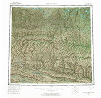
1956 Map of Lookout Ridge
USGS Topo · Published 1968About this map
Naval Petroleum Reserve No 4 dominates the central landscape of this North Slope interior, a region defined by extensive river systems and long, east-west trending ridges. The topography is marked by significant elevations like Shaningarok Ridge and Kulugra Ridge, which separate the north-flowing waters of the Meade River and Usuktuk River from the southern drainages. To the south, Lookout Ridge runs parallel to the Colville River, where tributaries such as Grayling Creek and Carbon Creek carve through the terrain. A solitary Tractor Trail provides a rare inland transport route, crossing Birthday Pass and connecting the Awuna River valley with the Titaluk River to the northeast. This 1956 survey, derived from aerial photography, illustrates the vast, unpopulated character of the Arctic tundra before modern infrastructure, dotted only by vertical angle bench marks like VABM 1360 Birthday and VABM 219 Nuki used for early geodetic mapping.
Find a feature on this map
61 named features on this map. Tap any name to fly to it.
Don’t see what you’re looking for? This feature index may not catch every label — zoom into the map to look around manually.
Map Details
Editions of this 1956 Lookout Ridge Map
5 editions found

Other maps of this area

1951 · Utukok River
USGS Topo · 1:250,000

1951 · Meade River
USGS Topo · 1:250,000

1951 · Wainwright
USGS Topo · 1:250,000

1951 · Lookout Ridge
USGS Topo · 1:250,000

1951 · Teshekpuk
USGS Topo · 1:250,000

1951 · Ikpikpuk River
USGS Topo · 1:250,000

1951 · Howard Pass
USGS Topo · 1:250,000

1951 · Misheguk Mountain
USGS Topo · 1:250,000

1951 · Killik River
USGS Topo · 1:250,000

1955 · Teshekpuk
USGS Topo · 1:250,000