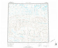
1956 Map of Lookout Ridge
USGS Topo · Published 1984About this map
Naval Petroleum Reserve No 4 dominates the central portion of this North Slope landscape, a region defined by its complex drainage networks and massive east-west ridges. The topography is anchored by the prominent Lookout Ridge and Shaningarok Ridge, which dictate the flow of numerous northern waterways. The Meade River and Awuna River wind through the interior, while the southern edge is marked by the course of the Colville River.
Find a feature on this map
25 named features on this map. Tap any name to fly to it.
Don’t see what you’re looking for? This feature index may not catch every label — zoom into the map to look around manually.
Map Details
Editions of this 1956 Lookout Ridge Map
5 editions found

Other maps of this area

1951 · Utukok River
USGS Topo · 1:250,000

1951 · Meade River
USGS Topo · 1:250,000

1951 · Wainwright
USGS Topo · 1:250,000

1951 · Lookout Ridge
USGS Topo · 1:250,000

1951 · Teshekpuk
USGS Topo · 1:250,000

1951 · Ikpikpuk River
USGS Topo · 1:250,000

1951 · Howard Pass
USGS Topo · 1:250,000

1951 · Misheguk Mountain
USGS Topo · 1:250,000

1951 · Killik River
USGS Topo · 1:250,000

1955 · Teshekpuk
USGS Topo · 1:250,000