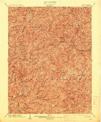
1904 Map of Vadis
USGS Topo · Published 1913About this map
The West Virginia counties of Doddridge and Lewis meet along a ridge-and-hollow landscape defined by its complex drainage network. Surveyed at the dawn of the twentieth century, the region's geography is anchored by rural centers like New Milton, Vadis, and Freemansburg, which served as vital collection points for the surrounding agricultural and logging operations. The intricate topography is carved by numerous waterways, including the winding Meathouse Fork and the Righthand Fork, where small farmsteads and schools typically followed the narrow valley floors. The presence of Sugarloaf provides a distinct landmark amidst the repetitive hills. The boundary line between Doddridge, Harrison, and Lewis counties follows these high ridgelines, illustrating how natural elevation shaped early political and property divisions in this part of the state.
Find a feature on this map
93 named features on this map. Tap any name to fly to it.
Don’t see what you’re looking for? This feature index may not catch every label — zoom into the map to look around manually.
Map Details
Editions of this 1904 Vadis Map
2 editions found
Other maps of this area

1893 · Buckhannon
USGS Topo · 1:125,000

1893 · Sutton
USGS Topo · 1:125,000

1896 · Buckhannon
USGS Topo · 1:125,000

1897 · Buckhannon
USGS Topo · 1:125,000

1902 · Clarksburg
USGS Topo · 1:62,500

1904 · Weston
USGS Topo · 1:62,500

1904 · Vadis
USGS Topo · 1:62,500

1905 · Centerpoint
USGS Topo · 1:62,500

1905 · West Union
USGS Topo · 1:62,500

1906 · Holbrook
USGS Topo · 1:62,500