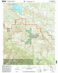
1997 Map of Vail Lake
USGS Topo · Published 2000About this map
The Pauba Grant and the sprawling Agua Tibia Wilderness dominate this corner of Riverside County in the late 1990s. The landscape is defined by the sharp transition from the open waters of Vail Lake and the Aguanga Valley to the steep, wooded reaches of the Cleveland National Forest. Evidence of early twentieth-century occupation and travel remains visible through markers like the Crosley Homestead and the historic alignment of the Butterfield Stage Road winding through Lancaster Valley. In the high country, remote landmarks such as Eagle Crag and Crosley Saddle serve as anchor points for rugged trails like the Palomar Divide Tr and Magee Trail. This revision highlights the area's complex geography, from the Cahuilla Indian Reservation in the south to the small settlement of Radec, providing a detailed look at the rural backcountry before modern expansion.
Find a feature on this map
33 named features on this map. Tap any name to fly to it.
Don’t see what you’re looking for? This feature index may not catch every label — zoom into the map to look around manually.
Map Details
Editions of this 1997 Vail Lake Map
This is the sole edition of this map. No revisions or reprints were ever made.
Other maps of this area

1901 · Southern California Sheet No. 1
USGS Topo · 1:250,000

1901 · San Jacinto
USGS Topo · 1:125,000

1901 · Elsinore
USGS Topo · 1:125,000

1901 · San Luis Rey
USGS Topo · 1:125,000

1903 · Ramona
USGS Topo · 1:125,000

1904 · Southern California Sheet No. 2
USGS Topo · 1:250,000

1904 · Southern California Sheet No. 1
USGS Topo · 1:250,000

1939 · Palomar Mountain
USGS Topo · 1:62,500

1942 · Temecula
USGS Topo · 1:62,500

1942 · Hemet
USGS Topo · 1:62,500