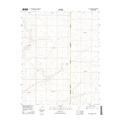
2014 Map of Valle Bonito NE
USGS Topo · Published 2014About this map
Bonito Valle dominates this high-desert landscape along the border of Arizona and New Mexico. This 2014 survey captures a sparsely populated stretch of the Southwest, where the state line also serves as the boundary between Apache County, Arizona and Cibola County, New Mexico. The terrain is defined by natural water sources and drainage patterns, including the notable Pine Springs and the meandering path of Aguaje Draw. Transportation through this arid region relies on a combination of modern county routes like CR-6268 and traditional paths such as the Zuni Trl, which winds across the eastern half of the map. The spatial organization of the land is visible through the section lines of the Public Land Survey System, illustrating how this remote territory is partitioned into various townships and ranges.
Find a feature on this map
7 named features on this map. Tap any name to fly to it.
Don’t see what you’re looking for? This feature index may not catch every label — zoom into the map to look around manually.
Map Details
Editions of this 2014 Valle Bonito NE Map
This is the sole edition of this map. No revisions or reprints were ever made.
Other maps of this area

1886 · St Johns
USGS Topo · 1:250,000

1892 · St Johns
USGS Topo · 1:250,000

1954 · Saint Johns
USGS Topo · 1:250,000

1957 · Saint Johns
USGS Topo · 1:250,000

1958 · Saint Johns
USGS Topo · 1:250,000

1962 · Saint Johns
USGS Topo · 1:250,000

1972 · Twentytwo Spring
USGS Topo · 1:24,000

1972 · Cantaralo Spring
USGS Topo · 1:24,000
1972 · Venadito Camp
USGS Topo · 1:24,000
1977 · Ceadro Spring
USGS Topo · 1:24,000