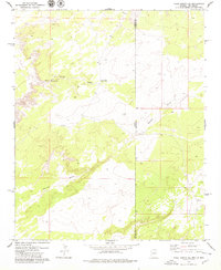
1978 Map of Valle Bonito NE
USGS Topo · Published 1979About this map
Lynch Ranch and the landmark high ground at Hinkson define this high-desert landscape situated directly on the border between Arizona and New Mexico. Surveyed in the late 1970s, the map reveals a rugged terrain dominated by seasonal drainages, most notably Pine Springs Wash and Aguaje Draw. This sparsely settled area, spanning the line between Apache County, Arizona and Valencia County, New Mexico, shows the essential water infrastructure required for ranching in such an environment, including the Pine Springs Well. The map captures a specific moment in the rural West, recording the intersections of state lines and county boundaries against a backdrop of complex natural topography.
Find a feature on this map
7 named features on this map. Tap any name to fly to it.
Don’t see what you’re looking for? This feature index may not catch every label — zoom into the map to look around manually.
Map Details
Editions of this 1978 Valle Bonito NE Map
2 editions found
Other maps of this area

1886 · St Johns
USGS Topo · 1:250,000

1892 · St Johns
USGS Topo · 1:250,000

1954 · Saint Johns
USGS Topo · 1:250,000

1957 · Saint Johns
USGS Topo · 1:250,000

1958 · Saint Johns
USGS Topo · 1:250,000

1962 · Saint Johns
USGS Topo · 1:250,000

1972 · Twentytwo Spring
USGS Topo · 1:24,000

1972 · Cantaralo Spring
USGS Topo · 1:24,000
1972 · Venadito Camp
USGS Topo · 1:24,000
1977 · Ceadro Spring
USGS Topo · 1:24,000