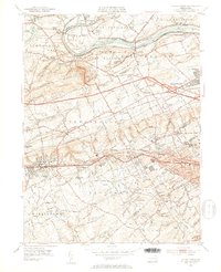
1952 Map of Valley Forge
USGS Topo · Published 1953About this map
Valley Forge State Park and its surrounding townships reflect the suburban transition of Montgomery, Chester, and Delaware Counties in the early 1950s. The site of Washingtons Headquarters and the Memorial Arch are preserved alongside the winding Schuylkill River, which remains a focal point for industry and transit with Reading Tracks lining its banks. To the south, the Main Line corridor is densely established, showing the growth of Paoli, Wayne, and Berwyn along the Pennsylvania Railroad.
Find a feature on this map
83 named features on this map. Tap any name to fly to it.
Don’t see what you’re looking for? This feature index may not catch every label — zoom into the map to look around manually.
Map Details
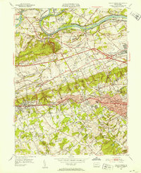
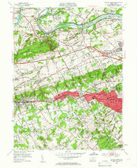
Editions of this 1952 Valley Forge Map
3 editions found
Other maps of this area

1894 · Chester
USGS Topo · 1:62,500

1894 · Norristown
USGS Topo · 1:62,500

1895 · Norristown
USGS Topo · 1:62,500

1896 · Norristown
USGS Topo · 1:62,500

1896 · Chester
USGS Topo · 1:62,500

1898 · Chester
USGS Topo · 1:62,500

1901 · Camden
USGS Topo · 1:125,000

1901 · West Chester
USGS Topo · 1:62,500

1904 · West Chester
USGS Topo · 1:62,500

1906 · Phoenixville
USGS Topo · 1:62,500
Featured Places
- Radnor Township, PA
- King of Prussia, Upper Merion Township
- Willistown Township, PA
- Charlestown Township, PA
- Chesterbrook, Tredyffrin Township