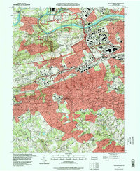
1992 Map of Valley Forge
USGS Topo · Published 1998About this map
Valley Forge National Historical Park anchors this landscape, preserving the hallowed ground where the Continental Army wintered. The map details commemorative landmarks including Washingtons Headquarters, the Washington Memorial, and the Memorial Arch. Beyond the park boundaries, the transition from revolutionary history to suburban expansion is evident in the dense residential networks of King of Prussia and Wayne. The presence of Great Valley Mills and various quarries points to the area's industrial roots, while numerous institutional sites like the Valley Forge Military Academy and Cathcart Home reflect the established social infrastructure of Chester and Montgomery Counties in the late 20th century. Transportation corridors like the Pennsylvania Turnpike and Schuylkill Expressway bisect the terrain, cutting through the older patterns of river-based settlements like Betzwood and Port Kennedy along the Schuylkill River.
Find a feature on this map
107 named features on this map. Tap any name to fly to it.
Don’t see what you’re looking for? This feature index may not catch every label — zoom into the map to look around manually.
Map Details
Editions of this 1992 Valley Forge Map
This is the sole edition of this map. No revisions or reprints were ever made.
Other maps of this area

1894 · Chester
USGS Topo · 1:62,500

1894 · Norristown
USGS Topo · 1:62,500

1895 · Norristown
USGS Topo · 1:62,500

1896 · Norristown
USGS Topo · 1:62,500

1896 · Chester
USGS Topo · 1:62,500

1898 · Chester
USGS Topo · 1:62,500

1901 · Camden
USGS Topo · 1:125,000

1901 · West Chester
USGS Topo · 1:62,500

1904 · West Chester
USGS Topo · 1:62,500

1906 · Phoenixville
USGS Topo · 1:62,500
Featured Places
- Radnor Township, PA
- King of Prussia, Upper Merion Township
- Willistown Township, PA
- Charlestown Township, PA
- Chesterbrook, Tredyffrin Township