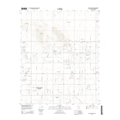
2015 Map of Valley Mountain
USGS Topo · Published 2015About this map
Twentynine Palms and the surrounding Mojave Desert characterize this desert landscape, where the northern residential periphery of the city meets the rising terrain of Valley Mtn. The map highlights a transition from established grid streets to more evocative, localized naming conventions, such as Peter Rabbit Trl and Back of Beyond Rd. Aviation history is well-represented by multiple facilities, including the Twentynine Palms Airport, Crosswinds Airport, and the Dick Dale Skyranch further north. This region's infrastructure is defined by long, straight desert thoroughfares like Amboy Rd and Telephone Rd, which cut through the arid flats to connect remote outposts. The ephemeral nature of water in this environment is noted by the presence of Dog Wash, a natural drainage feature located in the southern portion of the quadrangle.
Find a feature on this map
101 named features on this map. Tap any name to fly to it.
Don’t see what you’re looking for? This feature index may not catch every label — zoom into the map to look around manually.
Map Details
Editions of this 2015 Valley Mountain Map
This is the sole edition of this map. No revisions or reprints were ever made.
Other maps of this area

1942 · Amboy
USGS Topo · 1:250,000

1943 · Amboy
USGS Topo · 1:250,000

1953 · San Bernardino
USGS Topo · 1:250,000

1954 · Needles
USGS Topo · 1:250,000

1954 · Valley Mtn
USGS Topo · 1:24,000

1955 · Deadman Lake SE
USGS Topo · 1:24,000

1955 · Lead Mountain SW
USGS Topo · 1:24,000

1955 · Twentynine Palms
USGS Topo · 1:24,000
1955 · Cleghorn Lakes
USGS Topo · 1:24,000

1955 · Twentynine Palms
USGS Topo · 1:62,500