
1955 Map of Twentynine Palms
USGS Topo · Published 1956About this map
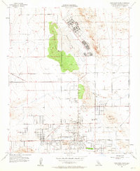
Twentynine Palms is captured during a period of significant desert mid-century development, framed by the expansive Marine Corps Training Center to the north and the northern edge of Joshua Tree National Monument to the south. The settlement pattern shows a formalizing grid of streets such as Larrea Ave and Sullivan Road, centering on landmarks like The Plaza and the Nat Monument Admin Building. The landscape is a study in desert hydrology and land use, featuring the Oasis of Mara, the ephemeral Mesquite Lake, and several small water sources like Mesquite Spring and Shortz Lake. Local history is preserved in the location of the Cemetery, the High School, and the Chemehuevi Indian Res, while the presence of the Naval Reservation and military training grounds indicates the growing federal footprint in the High Desert during the mid-1950s.
Find a feature on this map
34 named features on this map. Tap any name to fly to it.
Don’t see what you’re looking for? This feature index may not catch every label — zoom into the map to look around manually.
Map Details
Editions of this 1955 Twentynine Palms Map
2 editions found
Other maps of this area

1942 · Amboy
USGS Topo · 1:250,000

1943 · Amboy
USGS Topo · 1:250,000

1953 · San Bernardino
USGS Topo · 1:250,000

1954 · Needles
USGS Topo · 1:250,000

1954 · Valley Mtn
USGS Topo · 1:24,000

1955 · Deadman Lake SE
USGS Topo · 1:24,000

1955 · Deadman Lake SW
USGS Topo · 1:24,000

1955 · Lead Mountain SW
USGS Topo · 1:24,000

1955 · Twentynine Palms
USGS Topo · 1:62,500
1955 · Deadman Lake
USGS Topo · 1:62,500
Featured Places
- Twentynine Palms, CA
- Smoke Tree, Twentynine Palms
- Harmony Acres, Twentynine Palms
- San Bernardino County, CA
- United States