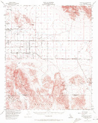
1956 Map of Valley Mountain
USGS Topo · Published 1972About this map
Mining operations and aviation facilities define this mid-century desert landscape along the border of San Bernardino and Riverside counties. The region is a dense network of extraction, featuring established sites like the Copper World Mine, Virginia Dale Mine, and the Imperial Mine in the north. Further south, the Music Mountains and Valley Mountains provide a backdrop for specialized operations including the Marbolite Mine, Goat Basin Mine, and Gold Park.
Find a feature on this map
38 named features on this map. Tap any name to fly to it.
Don’t see what you’re looking for? This feature index may not catch every label — zoom into the map to look around manually.
Map Details
Editions of this 1956 Valley Mountain Map
3 editions found
Other maps of this area

1942 · Amboy
USGS Topo · 1:250,000

1943 · Amboy
USGS Topo · 1:250,000

1943 · Pinkham Well
USGS Topo · 1:62,500

1944 · Pinkham Well
USGS Topo · 1:62,500

1944 · Eagle Tank
USGS Topo · 1:62,500

1944 · Pinyon Well
USGS Topo · 1:62,500

1947 · Santa Ana
USGS Topo · 1:250,000

1949 · Santa Ana
USGS Topo · 1:250,000

1953 · San Bernardino
USGS Topo · 1:250,000

1954 · Salton Sea
USGS Topo · 1:250,000