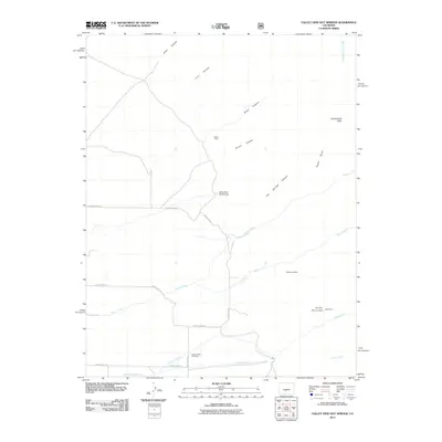
2011 Map of Valley View Hot Springs
USGS Topo · Published 2011About this map
Valley View Hot Springs sits at the base of the Sangre de Cristo foothills, serving as a focal point for this Saguache County landscape. The mapping reveals a history of extraction and water management, notably through clustered mineral interests like the Orient Mine, Old Bennet Mine, and the Millie Luna Mine. These sites are linked by rugged drainages such as Orient Canyon and Hot Springs Canyon, which channel water toward the valley floor. To the south, the agricultural requirements of the region are evident in the engineered paths of the Cotton Creek Ditch and the Hoffman Niedhardt Ditch. Cultural history is anchored at the Cotton Creek Cemetery, situated near the confluence of local mountain streams like Cotton Creek and Major Creek, illustrating the long-standing connection between the area's residents and its vital water sources.
Find a feature on this map
28 named features on this map. Tap any name to fly to it.
Don’t see what you’re looking for? This feature index may not catch every label — zoom into the map to look around manually.
Map Details
Editions of this 2011 Valley View Hot Springs Map
This is the sole edition of this map. No revisions or reprints were ever made.
Other maps of this area

1950 · Valley View Hot Springs
USGS Topo · 1:24,000

1954 · Pueblo
USGS Topo · 1:250,000

1957 · Pueblo
USGS Topo · 1:250,000

1958 · Pueblo
USGS Topo · 1:250,000

1959 · Electric Peak
USGS Topo · 1:62,500

1959 · Howard
USGS Topo · 1:62,500

1959 · Cotopaxi
USGS Topo · 1:62,500

1962 · Pueblo
USGS Topo · 1:250,000

1966 · Pueblo
USGS Topo · 1:250,000
1967 · Valley View Hot Springs
USGS Topo · 1:24,000