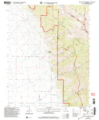
2001 Map of Valley View Hot Springs
USGS Topo · Published 2005About this map
Valley View Hot Springs anchors the western foothills of the Sangre de Cristo Mountains, where the high desert of the San Luis Valley meets the steep rise of the San Isabel National Forest. This landscape is defined by the transition from open drainage basins like Garner Creek and Cotton Creek to the sharp, narrow cuts of Black Canyon and Orient Canyon. The area shows a history of resource extraction, most notably at the Orient Mine and several other unnamed mines and prospects tucked into the mountain slopes.
Find a feature on this map
30 named features on this map. Tap any name to fly to it.
Don’t see what you’re looking for? This feature index may not catch every label — zoom into the map to look around manually.
Map Details
Editions of this 2001 Valley View Hot Springs Map
This is the sole edition of this map. No revisions or reprints were ever made.
Other maps of this area

1950 · Valley View Hot Springs
USGS Topo · 1:24,000

1954 · Pueblo
USGS Topo · 1:250,000

1957 · Pueblo
USGS Topo · 1:250,000

1958 · Pueblo
USGS Topo · 1:250,000

1959 · Electric Peak
USGS Topo · 1:62,500

1959 · Howard
USGS Topo · 1:62,500

1959 · Cotopaxi
USGS Topo · 1:62,500

1962 · Pueblo
USGS Topo · 1:250,000

1966 · Pueblo
USGS Topo · 1:250,000
1967 · Valley View Hot Springs
USGS Topo · 1:24,000